
Saumane (Alpes-de-Haute-Provence)
| Saumane | ||
|---|---|---|

|
|
|
| region | Provence-Alpes-Cote d'Azur | |
| Department | Alpes-de-Haute-Provence | |
| Arrondissement | Forcalquier | |
| Canton | Reillanne | |
| Community association | Haute-Provence Pays de Banon | |
| Coordinates | 44 ° 5 ' N , 5 ° 41' E | |
| height | 746-980 m | |
| surface | 3.21 km 2 | |
| Residents | 118 (January 1, 2017) | |
| Population density | 37 inhabitants / km 2 | |
| Post Code | 04150 | |
| INSEE code | 04201 | |
 Place view |
||

Saumane is a French municipality with 118 inhabitants (at January 1, 2017) in the department of Alpes-de-Haute-Provence in the region Provence-Alpes-Cote d'Azur . It belongs to the canton of Reillanne in the Forcalquier arrondissement . Saumane is bordered by L'Hospitalet and Lardiers to the east, Banon to the south and La Rochegiron to the west .
Population development
| year | 1962 | 1968 | 1975 | 1982 | 1990 | 1999 | 2008 | 2016 |
|---|---|---|---|---|---|---|---|---|
| Residents | 77 | 74 | 63 | 60 | 80 | 83 | 106 | 115 |
Attractions
- Pigeon house built in the 19th century
- Houses from the 18th / 19th century century
- Saint-Pierre-ès-Liens church
- Saint-Michel chapel

Saint-Pierre-ès-Liens church
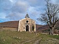
Saint-Michel chapel

Mairie Saumane


Web links
Commons : Saumane - collection of images, videos and audio files