
Schmitzdörfgen
|
Schmitzdörfgen
municipality Ruppichteroth
Coordinates: 50 ° 48 ′ 23 " N , 7 ° 24 ′ 39" E
|
|
|---|---|
| Height : | 230–246 m above sea level NHN |
| Residents : | 36 (March 31, 2016) |
| Postal code : | 53809 |
| Area code : | 02247 |
 Entrance
|
|
Schmitzdörfgen is part of the municipality of Ruppichteroth .
geography
The hamlet is in the Derenbach valley . Neighboring towns are Derenbach in the northeast, Holenfeld in the east, Baumhof in the south and Bechlingen in the northwest.

Wayside cross in Schmitzdörfgen
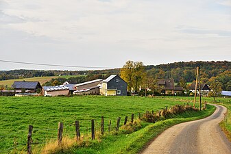
View over Schmitzdörfgen


history
In 1712 11 households with 57 souls lived here : Bertram Krey, Bertram Hatterscheid, Wilhelm Hoscheidts, Garard Schonauer, Johannes Griffroth, Philip Schwarz, widow Derenbachs, widow Peter Derenbachs, Diderich Griffroth and widow Bertram Griffroth.
In 1809 the place had 60 Catholic residents.
In 1910, the households Ackerer Adolf Baum, Ackerin Widow Wimar Baum, Ackerer Anton Fuchs, Ackerer Peter Halber, Ackerer Johann Patt, Bread Merchant Heinrich Josef Peters and the Ackerer Peter and Josef Schmitt were listed for Schmitzdörfgen. The village was therefore entirely agricultural.
In 2012 the population was 33, these were distributed over 12 households.
Individual evidence
- ^ Pension book of the church and pastorate Winterscheid, p. 199 ff
- ^ Karl Schröder : The civil community Ruppichteroth 1808-2006. Ruppichteroth - Schönenberg - Winterscheid. 100 years town hall in Schönenberg . Ed .: Ruppichteroth community. Franz Schmitt, Siegburg 2006, ISBN 3-87710-329-4 , p. 19 .
- ^ Population register Siegkreis 1910

Ahe |
Bacherhof |
Bechlingen |
Beiert |
Mountain |
Bölkum |
Bornscheid |
Bröleck |
Brölerhof |
Broscheid |
Büchel |
Dam |
Derenbach |
Dörgen |
Ennenbach |
Etzenbach |
Fußberg |
Carpus |
Giesselbach |
Hänscheid |
Hambuchen |
Harth |
Hatterscheid |
Herrenbröl |
Herrnstein |
Hodgeroth |
Holenfeld |
Honscheid |
Hove |
Ifang |
Ingersau |
Jünkersfeld |
Junkersaurenbach |
Kämerscheid |
Kammerich |
Kesselscheid |
Köttingen |
Krahwinkel |
Kuchem |
Litterscheid |
Millerscheid |
Mittelaurenbach |
Neuenhof near Ruppichteroth |
Neuenhof near Winterscheid |
Niederlückerath |
Niederpropach |
Niedersaurenbach |
Oberlückerath |
Obersaurenbach |
Oeleroth |
Paulinenthal |
Powder mill |
Reiferscheid |
Retscheroth |
Rose |
Rotscheroth |
Ruppichteroth |
Scheid |
Schmitzdörfgen |
Schmitzhöfgen |
Schneppe |
Schönenberg |
Schreckberg |
Stockum |
Stranzenbach |
Street |
Tanneck |
Thal |
Thilhove |
Velken |
Wingenbach |
Wingenbacherhof |
Winterscheid |
Winterscheiderbröl |
Winterscheider Mühle
former and submerged districts:
Bettringen |
Book |
Durchhausen |
Felderhof |
Felderhofer Bridge |
House Bröleck |
Heather |
Höfferhof |
Huppach |
Lindenhof |
Clamp break |
Sieferhof |
Stone |
Tüschenhohn |
Wilkenrotherhof