
Siebenmühlental (Schönbuch)

The Siebenmühlental , formerly known as Reichenbachtal , is the valley of the Reichenbach between Musberg, a district of Leinfelden-Echterdingen , and the mouth of the stream on the eastern edge of the urban area of Waldenbuch . The valley cut is roughly followed by the border between the Boeblingen district on his right and the Esslingen district on his left.
The current name "Siebenmühlental" refers to the mills mentioned in a document in 1383 as seven mulin in Richenbach , to which more were added later, all of which were driven by Reichenbach. The name was applied during the 1930s in an effort to develop the valley for tourism and to market it. With the exception of the donkey mill , none of the nine grain mills are used anymore. The Lower Kleinmichelesmühle and the Burkhardtsmühle house sawmills and wood stores.
Geographical location
The approximately south-east running valley lies in the subspace Northern Schönbuch the natural environment Schönbuch and Glemswald . It is about ten kilometers long from Musberg. The Schönbuch Nature Park borders on the confluence with the Aich from the south .
Historical sights
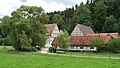
Today the buildings of eleven former grain mills and sawmills are located in Siebenmühlental :
- Upper mill (agriculture)
- Eselsmühle (restaurant, agriculture, grinding operation, bakery)
- Mäulesmühle (theater, restaurant)
- Seebruckenmühle
- Bad mill (agriculture)
- Schlösslesmühle (restaurant, agriculture)
- Roller mill (agriculture)
- Cooking mill (catering, agriculture)
- Upper Kleinmichelsmühle
- Lower Kleinmichelsmühle (sawmill)
- Burkhardtsmühle (restaurant, sawmill)

Cooking grinder
Bad mill

Schlösslesmühle


Federal hiking trail on the former railway line

The Siebenmühlentalbahn was a standard-gauge branch line that ran from Stuttgart-Vaihingen via Leinfelden to Waldenbuch through the Siebenmühlental. It was opened on June 23, 1928 and shut down in 1955/1956. On this former railway line of the Deutsche Reichsbahn runs an asphalted hiking trail that is still owned by the federal government and therefore bears the unusual name "Bundeswanderweg".

Nature reserve
In an ordinance of October 6, 2010, the Stuttgart Regional Council designated the Siebenmühlental as a nature reserve with protected area number 1276. The nature reserve has an area of 98.5 hectares, of which 52.6 hectares are in the Esslingen district and 45.8 hectares in the Böblingen district.
Protection purposes are:
- Protection of the landscape with all its unique surface forms
- Protection of the small-scale mosaic of soil surfaces including the promotion of large-scale grassland areas
- Protection of rivers and streams and other biotopes, precautionary measures for biotope development and species protection measures
- Preservation, promotion, development and restoration of the rich biotope and species potential of wild flora and fauna
- Protection and transmission of the historical cultural landscape
The valley is home to over 200 species of plants, 80 species of birds, 14 species of reptiles and amphibians and over 50 species of day and night moths.
See also
- List of nature reserves in the Esslingen district
- List of nature reserves in the Boeblingen district
Individual evidence
- ^ Landesarchiv Baden-Württemberg: Der Landkreis Esslingen, Volume 1 , Jan Thorbecke Verlag, Ostfildern 2009, p. 532.
- ^ Friedrich Huttenlocher , Hansjörg Dongus : Geographical land survey: The natural spatial units on sheet 170 Stuttgart. Federal Institute for Regional Studies, Bad Godesberg 1949, revised 1967. → Online map (PDF; 4.0 MB)
- ^ Law Gazette for Baden-Württemberg of November 17, 2010, p. 771.
Web links
- Profile of the nature reserve in the LUBW's list of protected areas
- Siebenmühlental
- Siebenmühlental


Feuerbacher Heide-Dickenberg | Gerlinger Heide | Grafenberg | Hacksberg and Steckental | Hartmannsberg | Hinteres Sommerhofental | Kappelwiesen-At the Red Fountain-Salt Meadows | Kasparsbrunnen-Ried-Binn | Krebsbachaue | Längenbühl | Merklinger Ried | Mittelberg | Neuweiler Cattle Pasture | Upper Hölzertal | Schaichtal | Siebenmühlental | Storrenberg | Venusberg-Wolfsäcker-Besental / Halde | Forest meadow in Mahdental | Würmaue on the Heuberg

Old Neckar | Am Rank (Röhmsee) | Denkendorfer Erlachsee | Eichhalde | Erkenbergwasen | Grienwiesen (Schülesee) | Haslachwald | Jusi - On the mountain | Crow's Claw | Kurzer Wasen-Roter Wasen | Limburg | Musberger Eichberg | Nägelestal | Neckarwasen | Neuffen Heath | Neuffener Hörnle-Jusenberg | Upper Lenninger Valley with side valleys | Randecker Maar with Zipfelbach Gorge | Schaichtal | Schönrain | Schopflocher Moor (peat pit) | Siebenmühlental | Stettener Bach | Teck | Tobeltal with Mittagsfels and Wielandstein | Under the fall | Wernauer Baggerseen | Wernau clay pit | Wiestal with Rauber
Coordinates: 48 ° 40 ′ 0 ″ N , 9 ° 9 ′ 0 ″ E