Silnice I / 62
| Silnice I / 62 in the Czech Republic | |

|
|
| map | |
| Basic data | |
| Operator: | Ředitelství silnic a dálnic ČR |
| Start of the street: | Usti nad Labem ( 50 ° 39 ' N , 14 ° 3' O ) |
| End of street: | Hřensko ( 50 ° 53 ′ N , 14 ° 14 ′ E ) |
| Overall length: | 37.379 km |
| of which in operation: | 37.379 km |
|
Kraj ( region ): |
|
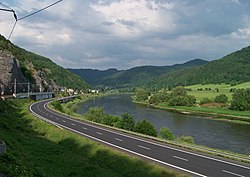
| The road near Roztoky | |
The Silnice I / 62 ( Czech for: "1st class road 62") is a Czech state road (1st class road).
course
The street starts in Ústí nad Labem (Aussig) at Silnice I / 30 . It follows the left bank of the Elbe downstream, meets the district of Podmokly (Bodenbach) the city of Decin (Decin) to the Silnice I / 13 , which also here the European route E442 forms, crossed with this on a bridge, the same follows from this city from the right bank of the Elbe until it reaches the border with the Federal Republic of Germany north of Hřensko (Herrnskretschen) at the lowest point in the Czech Republic and at the border merges into the federal highway 172 , which at Bad Schandau returns to the left bank of the Elbe changes.
The length of the road is around 37 kilometers.
particularities
The transition to Germany can only be made by vehicles with a total weight of up to 3.5 tons.
In its northern section, the road opens up access to the Bohemian Switzerland National Park and the CHKO Labské pískovce protected landscape area to the south .
history
The road was built after the annexation of the Sudetenland by the German Reich in 1938 and put into operation. It was designated as part of Reichsstrasse 172 until 1945
