
Chamarande
| Chamarande | ||
|---|---|---|
.svg)
|
|
|
| region | Île-de-France | |
| Department | Essonne | |
| Arrondissement | Etampes | |
| Canton | Dourdan | |
| Community association | Entre Juine et Renarde | |
| Coordinates | 48 ° 31 ' N , 2 ° 13' E | |
| height | 62–155 m | |
| surface | 5.74 km 2 | |
| Residents | 1,147 (January 1, 2017) | |
| Population density | 200 inhabitants / km 2 | |
| Post Code | 91730 | |
| INSEE code | 91132 | |
| Website | www.chamarande.fr | |

Chamarande is a municipality in the department of Essonne in the region of Ile-de-France in France . It has 1,147 inhabitants (as of January 1, 2017). Chamarande belongs to the Arrondissement of Étampes and the Canton of Dourdan (until 2015: Canton of Étréchy ). The inhabitants are called Chamarandais .
geography
Chamarande is located on the banks of the Juine River about 39 kilometers south of central Paris . The municipality is located in the Gâtinais français Regional Nature Park . Chamarande is surrounded by the neighboring communities Boissy-sous-Saint-Yon in the north, Torfou in the northeast, Lardy in the east, Janville-sur-Juine in the southeast, Auvers-Saint-Georges in the south, Étréchy in the southwest and Mauchamps in the west.
Population development
| year | 1962 | 1968 | 1975 | 1982 | 1990 | 1999 | 2006 | 2013 |
| Residents | 754 | 863 | 668 | 757 | 901 | 1,016 | 1,066 | 1,143 |
| Source: Cassini and INSEE | ||||||||
Attractions
See also: List of Monuments historiques in Chamarande
- Saint-Quentin church from the 12th / 13th centuries century
- 17th century castle
- Wash house
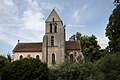
Saint-Quentin Church
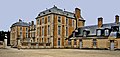
Chamarande Castle


Community partnerships
A partnership has existed with Lentiai , part of the municipality of Borgo Valbelluna in the province of Belluno (Veneto), since 1970.
literature
- Le Patrimoine des Communes de l'Essonne. Flohic Éditions, Paris 2001, Volume 1, ISBN 2-84234-126-0 , pp. 343-347.