
Le Val-Saint-Germain
| Le Val-Saint-Germain | ||
|---|---|---|
|
||
| region | Île-de-France | |
| Department | Essonne | |
| Arrondissement | Etampes | |
| Canton | Dourdan | |
| Community association | Dourdannais en Hurepoix | |
| Coordinates | 48 ° 34 ' N , 2 ° 4' E | |
| height | 62-159 m | |
| surface | 12.57 km 2 | |
| Residents | 1,475 (January 1, 2017) | |
| Population density | 117 inhabitants / km 2 | |
| Post Code | 91530 | |
| INSEE code | 91630 | |
| Website | http://www.le-val-saint-germain.fr/ | |
_mairie_1095.jpg) Town hall (Mairie) of Le Val-Saint-Germain |
||

Le Val-Saint-Germain is a commune with 1,475 inhabitants (as of January 1 2017) in the department of Essonne in the region of Ile-de-France ; it belongs to the arrondissement of Étampes and the canton of Dourdan (until 2015: canton of Saint-Chéron ). The inhabitants are called Val-Saint-Germinois .
geography
Le Val-Saint-Germain is located about 38 kilometers south-southwest of Paris on the Rémarde River . Le Val-Saint-Germain is surrounded by the neighboring municipalities of Angervilliers in the north, Vaugrigneuse in the northeast, Saint-Maurice-Montcouronne in the east, Saint-Chéron in the southeast, Sermaise in the south, Roinville in the southwest and Saint-Cyr-sous-Dourdan in the west .
Population development
| year | 1962 | 1968 | 1975 | 1982 | 1990 | 1999 | 2006 | 2012 |
| Residents | 460 | 409 | 509 | 683 | 1,147 | 1,438 | 1,455 | 1,427 |
| Source: Cassini and INSEE | ||||||||
Attractions
- Church of Saint-Germain from the 11th century, today's building mainly from the 16th century
- Le Marai Castle, built in 1770, has been a monument historique since 1965
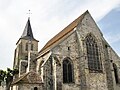
Saint Germain Church

Le Marais Castle


Personalities
- Jean Pons Viennet (1777–1868), politician and writer
- Marcel Fleury (1884–1949), Bishop of Nancy (1934–1949)
- Gaston Palewski (1901–1984), politician and ambassador
literature
- Le Patrimoine des Communes de l'Essonne. Flohic Éditions, Volume 2, Paris 2001, ISBN 2-84234-126-0 , pp. 897-900.
Web links
Commons : Le Val-Saint-Germain - Collection of images, videos and audio files