
Saint-Cyr-sous-Dourdan
| Saint-Cyr-sous-Dourdan | ||
|---|---|---|
|
||
| region | Île-de-France | |
| Department | Essonne | |
| Arrondissement | Etampes | |
| Canton | Dourdan | |
| Community association | Dourdannais en Hurepoix | |
| Coordinates | 48 ° 34 ' N , 2 ° 2' E | |
| height | 72-160 m | |
| surface | 9.89 km 2 | |
| Residents | 978 (January 1, 2017) | |
| Population density | 99 inhabitants / km 2 | |
| Post Code | 91410 | |
| INSEE code | 91546 | |
_mairie_1080a.jpg) Town hall ( Mairie ) of Saint-Cyr-sous-Dourdan |
||

Saint-Cyr-sous-Dourdan is a commune in the department of Essonne in the region of Ile-de-France in France . It has 978 inhabitants (as of January 1, 2017). Saint-Cyr-sous-Dourdan belongs to the Arrondissement of Étampes and the Canton of Dourdan (until 2015: Canton Saint-Chéron ). The inhabitants are called Saint-Cyriens .
geography
Saint-Cyr-sous-Dourdan is about 39 kilometers southwest of central Paris on the Rémarde . Saint-Cyr-sous-Dourdan is surrounded by the neighboring communities of Angervilliers in the north and north-east, Le Val-Saint-Germain in the east, Roinville in the south, Dourdan in the south and south-west and Longvilliers in the west.
Population development
| year | 1962 | 1968 | 1975 | 1982 | 1990 | 1999 | 2006 | 2013 |
| Residents | 453 | 459 | 640 | 774 | 846 | 951 | 992 | 1.006 |
| Source: Cassini and INSEE | ||||||||
Attractions
See also: List of Monuments historiques in Saint-Cyr-sous-Dourdan
- Saint-Cyr-et-Sainte-Julitte church, monument historique since 1966
- Bandeville castle from the 17th century, monument historique since 1974
- 13th century Les Tourelles estate, 16th century renovations

Saint-Cyr-et-Sainte-Julitte church

Bandeville Castle
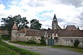
Les Tourelles farm


literature
- Le Patrimoine des Communes de l'Essonne. Flohic Éditions, Volume 2, Paris 2001, ISBN 2-84234-126-0 , pp. 883-884.