
Roinville (Essonne)
| Roinville | ||
|---|---|---|

|
|
|
| region | Île-de-France | |
| Department | Essonne | |
| Arrondissement | Etampes | |
| Canton | Dourdan | |
| Community association | Dourdannais en Hurepoix | |
| Coordinates | 48 ° 32 ' N , 2 ° 3' E | |
| height | 82-163 m | |
| surface | 13.4 km 2 | |
| Residents | 1,393 (January 1, 2017) | |
| Population density | 104 inhabitants / km 2 | |
| Post Code | 91410 | |
| INSEE code | 91525 | |
| Website | http://www.mairie-roinville.fr/ | |
_mairie_1090.jpg) City Hall (Mairie) of Roinville |
||

Roinville (also: Roinville-sous-Dourdan ) is a French municipality with 1,393 inhabitants (as of January 1 2017) in the department of Essonne in the region of Ile-de-France ; it belongs to the arrondissement of Étampes and is part of the canton of Dourdan . The inhabitants are called Roinvillois .
geography
Roinville is located about 42 kilometers south-southwest of Paris on the Orge . Roinville is surrounded by the neighboring municipalities of Saint-Cyr-sous-Dourdan in the north and north-west, Le Val-Saint-Germain in the north-east, Sermaise in the east, Boissy-le-Sec in the south-east, La Forêt-le-Roi in the south, Les Granges -le-Roi in the southwest and Dourdan in the west and northwest.
Population development
| year | 1962 | 1968 | 1975 | 1982 | 1990 | 1999 | 2006 | 2013 |
| Residents | 348 | 416 | 396 | 522 | 695 | 888 | 1,168 | 1,292 |
| Source: Cassini and INSEE | ||||||||
Attractions
See also: List of Monuments historiques in Roinville (Essonne)
- Saint-Denis church from the 11th century, renovations from the 15th century, monument historique since 1984
- Roinville Castle from the 17th century, a historic monument since 1945
- Ferme de Châteaupers from the 14th century, a historic monument since 1977
- Wash house , built in 1880
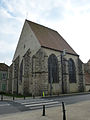
Saint-Denis church

Châteaupers manor


literature
- Le Patrimoine des Communes de l'Essonne. Flohic Éditions, Volume 1, Paris 2001, ISBN 2-84234-126-0 , pp. 237-238.