
Bouville (Essonne)
| Bouville | ||
|---|---|---|
.svg)
|
|
|
| region | Île-de-France | |
| Department | Essonne | |
| Arrondissement | Etampes | |
| Canton | Etampes | |
| Community association | Étampois Sud Essonne | |
| Coordinates | 48 ° 27 ' N , 2 ° 3' E | |
| height | 66–152 m | |
| surface | 20.53 km 2 | |
| Residents | 648 (January 1, 2017) | |
| Population density | 32 inhabitants / km 2 | |
| Post Code | 91150 | |
| INSEE code | 91100 | |
| Website | http://www.bouville-mairie.com/ | |
 Hôtel de Ville / Mairie (Town Hall) of Bouville |
||

Bouville is a French municipality with 648 inhabitants (as of January 1 2017) in the department of Essonne in the region of Ile-de-France ; it belongs to the arrondissement of Étampes and is part of the canton of Étampes . The inhabitants are called bouvillons .
geography
Bouville is located about 37 kilometers south-southwest of Paris . The municipality is located in the Gâtinais français Regional Nature Park . Bouville is surrounded by the neighboring communities of Angervilliers in the north and northwest, Vaugrigneuse in the northeast, Saint-Maurice-Montcouronne in the east and northeast, Saint-Chéron in the southeast, Sermaise in the south, Roinville in the southwest and Saint-Cyr-sous-Dourdan in the west.
Population development
| year | 1962 | 1968 | 1975 | 1982 | 1990 | 1999 | 2006 | 2013 |
| Residents | 286 | 301 | 361 | 492 | 533 | 538 | 664 | 639 |
| Source: Cassini and INSEE | ||||||||
Attractions
See also: List of Monuments historiques in Bouville (Essonne)
- Saint-Martin church from the 12th century, monument historique since 1946
- Farcheville Castle from the 13th century, monument historique since 1946

Saint Martin Church
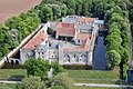
Farcheville Castle


Personalities
- Jean Chalopin (born 1950), director
literature
- Le Patrimoine des Communes de l'Essonne. Flohic Éditions, Paris 2001, Volume 1, ISBN 2-84234-126-0 , pp. 297-299.