Congerville-Thionville
| Congerville-Thionville | ||
|---|---|---|
|
|
||
| region | Île-de-France | |
| Department | Essonne | |
| Arrondissement | Etampes | |
| Canton | Etampes | |
| Community association | Étampois Sud Essonne | |
| Coordinates | 48 ° 23 ′ N , 1 ° 59 ′ E | |
| height | 113-151 m | |
| surface | 8.47 km 2 | |
| Residents | 221 (January 1, 2017) | |
| Population density | 26 inhabitants / km 2 | |
| Post Code | 91740 | |
| INSEE code | 91613 | |
Congerville-Thionville is a French municipality with 221 inhabitants (as of January 1 2017) in the department of Essonne in the region of Ile-de-France ; it belongs to the arrondissement of Étampes and is part of the canton of Étampes (until 2015: canton of Méréville ). The inhabitants are called Congervillois-Thionvillois .
geography
Congerville-Thionville is located about 59 kilometers south-southwest of Paris and about 14 kilometers southwest of Étampes . Congerville-Thionville is surrounded by the neighboring communities of Mérobert in the north, Chalou-Moulineux in the east, Pussay in the south, Gommerville in the southwest and Oysonville in the west.
The former route nationale 838 (today's D838) runs through the municipality .
history
The two districts of Congerville and Thionville were first mentioned in the 12th and 13th centuries. The municipalities were merged in 1973.
Population development
| year | 1962 | 1968 | 1975 | 1982 | 1990 | 1999 | 2006 | 2012 |
| Residents | 194 | 178 | 176 | 159 | 187 | 225 | 221 | 232 |
| Source: Cassini and INSEE | ||||||||
Attractions
- Saint-Gilles Church
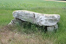
- The Dolmen le Grès de Linas from the Neolithic Age, Monument historique since 1970
literature
- Le Patrimoine des Communes de l'Essonne. Flohic Éditions, Volume 2, Paris 2001, ISBN 2-84234-126-0 , pp. 650–652.

