Silnice I / 60
| Silnice I / 60 in the Czech Republic | |||||||||||||||||||

|
|||||||||||||||||||
| map | |||||||||||||||||||
| Basic data | |||||||||||||||||||
| Operator: | Ředitelství silnic a dálnic ČR | ||||||||||||||||||
| Overall length: | 32.643 km | ||||||||||||||||||
| of which in operation: | 32.643 km | ||||||||||||||||||
|
Kraj ( region ): |
Olomoucký kraj |
||||||||||||||||||
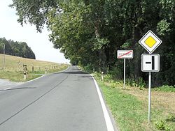
| Exit from the Bergov hamlet towards Javorník | |||||||||||||||||||
|
Course of the road
|
|||||||||||||||||||
The Silnice I / 60 ( Czech for: "1st class street 60") is a Czech state road (1st class street).
course
The road branches off from Silnice I / 44 in the Bukovice (Buchelsdorf) district of Jeseník (Freiwaldau) and runs in a north-westerly direction via Žulová (Friedeberg) to Javorník (Jauernig). From there it leads to the Czech-Polish border at Bílý Potok (Weißbach). In Poland , the Droga wojewódzka 382 is its continuation after Paczków (Patschkau).
The total length of the road is around 33 kilometers.
Individual evidence
- ↑ Freytag & Berndt Autoatlas Česko, 2010 edition, ISBN 978-80-7316-056-2

