Silnice I / 14
| Silnice I / 14 in the Czech Republic | |

|
|
| map | |
| Basic data | |
| Operator: | Ředitelství silnic a dálnic ČR |
| Overall length: | 196 km |
| of which in operation: | 196 km |
|
Kraj ( region ): |
Liberecký kraj |
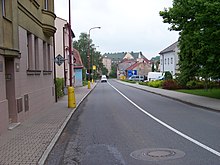
| The street in Trutnov (Trautenau) | |
The Silnice I / 14 ( Czech for: "1st class road 14") is a Czech state road (1st class road).
course
The road branches off from Silnice I / 35 in the south of the city of Liberec (Reichenberg) , leads, initially with four lanes, to Jablonec nad Nisou (Gablonz), takes up Silnice I / 65 there, continues in an easterly direction to Tanvald ( Tannwald), merges with the Silnice I / 10 for the next twelve kilometers , separates from it again before the hamlet Mýtiny (Strickerhäuser), turns to the south-southeast, leads through Jablonec nad Jizeru (Jablonetz) and north on Jilemnice (Starkenbach) and now runs in a generally eastward direction through Vrchlabí (Hohenelbe). From here it continues to Trutnov (Trautenau), runs a short distance together with the Silnice I / 16 , then turns back to the south-southeast and runs via Úpice (Eipel) and Červený Kostelec (Rothkosteletz) to Náchod , where you can see the Silnice I / 33 crosses. In its further course it runs through Nové Město nad Metují (Neustadt an der Mettau), Dobruška (Gutenfeld) and Rychnov nad Kněžnou (Reichenau an der Knieschna), crosses Silnice I / 11 in Vamberk (Wamberg) , continues to Ústí nad Orlicí (Wildenschwert) and Česká Třebová (Bohemian Trübau) and finally ends when they meet the Silnice I / 43 at Anenská Studánka (Königsfeld).
The length of the road is around 196 kilometers.
history
From 1940 to 1945 the road from Liberec to Náchod formed part of Reichsstrasse 150 .
Individual evidence
- ↑ Freytag & Berndt Autoatlas Česko, 2010 edition, ISBN 978-80-7316-056-2

