Červený Kostelec
| Červený Kostelec | ||||
|---|---|---|---|---|
|
||||
| Basic data | ||||
| State : |
|
|||
| Region : | Královéhradecký kraj | |||
| District : | After that | |||
| Area : | 2406 ha | |||
| Geographic location : | 50 ° 29 ' N , 16 ° 6' E | |||
| Height: | 414 m nm | |||
| Residents : | 8,352 (Jan 1, 2019) | |||
| Postal code : | 549 41 | |||
| traffic | ||||
| Street: | Náchod - Trutnov | |||
| Railway connection: | Jaroměř – Trutnov | |||
| structure | ||||
| Status: | city | |||
| Districts: | 7th | |||
| administration | ||||
| Mayor : | Petr Mědílek (as of 2007) | |||
| Address: | náměstí TG Masaryka 120 549 41 Červený Kostelec |
|||
| Municipality number: | 573965 | |||
| Website : | www.cervenykostelec.cz | |||
Červený Kostelec (German Rothkosteletz ) is a city in the Czech Republic . It is located eight kilometers northwest of Náchod and belongs to the Okres Náchod .
geography
The town is located on the river Olešnice . To the west lies the Aupa valley with the ruins of the Vízmburk castle , below which the river flows through the Babiččino údolí valley. In the southeast of Červený Kostelec are the ponds Špinka and Brodský rybník , both with a campsite. State road 14 runs through the town from Náchod to Trutnov .
Neighboring towns are Rtyně and Lhota za Červeným Kostelcem in the north, Bohdašín and Horní Kostelec in the northeast, Kostelecké Končiny and Horní Radechová in the east, Končiny and Zábrodí in the southeast, Olešnice in the south, Stolín in the southwest and Havlovice in the northwest.
history
The village Kostelec was first mentioned on August 22, 1362. It belonged to the Rothenburg rule and later to the Wiesenburg rule . After the Wiesenburg was razed by the Silesian cities in 1447, the Kostelec market was added to the Nachod rule .
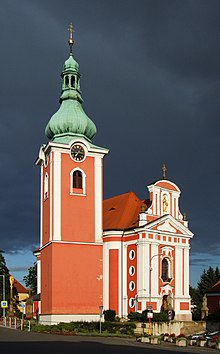
After the Trčka were expropriated from Lípa in 1634, the Nachod rule came to Octavio Piccolomini . In 1668 he initiated the reconstruction of the Kostelec church, which burned down in 1591. In the years 1744–1754 the church was replaced by a modified baroque building according to plans by Kilian Ignaz Dientzenhofer . In the 18th century the place developed into a center for linen weaving. On August 11, 1831, large parts of the village were destroyed by fire. Because of the painting of the church, the name Červený Kostelec ( Rothkosteletz ) became common. In 1841 Leopold Abeles founded the mechanical cotton spinning mill.
After the replacement of patrimonial Rothkosteletz belonged to the district administration Neustadt an der Mettau from the middle of the 19th century . With the construction of the railway from Josefstadt to Liebau by the Austrian Northwest Railway , Rothkosteletz received a railway connection in 1859. The Just dye works was established in 1860. The proximity to the East Bohemian coal field was also advantageous. On August 11, 1867, the Kosteletz market was elevated to the status of town and in the same year the addition of "Roth" or "Červený" to the town name was allowed. In 1880 the city had 2405 inhabitants. Since 1881 the official name of the city was "Rothkosteletz" or in Czech "Červený Kostelec". In 1889 there were 40 textile companies in Rothkosteletz with 312 employees, plus 84 textile traders. By 1910 the population grew to 4,422 and the number of houses almost doubled compared to 1880.
During the Second World War, Rothkosteletz belonged to the Protectorate of Bohemia and Moravia from 1939 to 1945 . The Sokol defense group S21 operated in the city and in Bohdašín and Končiny there was a refuge for Jiří Potůček (alias: Tolar), who had flown in from exile in London as part of Operation Silver A and who previously operated from Ležáky . After the group fell into the hands of the German occupiers, those involved were executed.
In 1948 the expropriated textile companies were nationalized. During the communist rule, textile manufacture, which had once brought work and bread to Červený Kostelec, lost its importance and mechanical engineering became the largest branch of industry in the town. In 1950 Lhota, Horní Kostelec, Stolín and Mstětin were incorporated. In 1960 Bohdašín and Olešnice were added.
Červený Kostelec has belonged to the Glacensis Euroregion since 1996 and is the center of the Úpa microregion.
Local division
The town of Červený Kostelec consists of the following districts:
- Bohdašín nad Olešnicí ( Bochdaschin )
- Červený Kostelec ( Rothkosteletz )
- Horní Kostelec ( Oberkosteletz )
- Lhota za Červeným Kostelcem ( Lhota behind Rothkosteletz )
- Mstětín ( Mistietin )
- Olešnice u Červeného Kostelce ( Woleschnitz )
- Stolín ( Stolin ).
Town twinning
- Küsnacht , Switzerland, since 1992
- Warrington , UK, since 1991
- Ząbkowice Śląskie , Poland, since 1993
Attractions
- Parish Church of James the Elder, on the market square. The baroque building, erected between 1744 and 1754, was built during the Silesian Wars, contrary to Dientzenhofer's original plans, by Franz Kermer with a significantly reduced nave and the removal of a tower.
- town hall
- Marian column on the market
- Chapel of St. Cyril and Methodius, in the cemetery
- Viktorka grave, symbolic grave for the insane Viktorka Židová, a character from the novel “ The Grandmother ” of Božena Němcová ; it was laid out in 1868 in the old cemetery at the Laurentiuskirche.
- Božena Němcová House
- , Theater by Tyl named
- Grandmother Valley
- Vízmburk castle ruins , the castle, built in 1279, was bought and razed in 1447 by the Silesian Association of Cities from the knight Georg von Dubá , who undertook raids from the castle into the Silesian cities.
sons and daughters of the town
- Viktor Kalabis (1923-2006), composer
- Karl-Hermann Körner (1941–1992), German Romanist
Web links
Individual evidence
- ↑ Český statistický úřad - The population of the Czech municipalities as of January 1, 2019 (PDF; 7.4 MiB)


