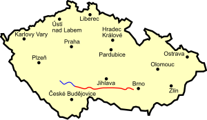
Silnice I / 23
| Silnice I / 23 in the Czech Republic | |

|
|
| map | |
| Basic data | |
| Operator: | Ředitelství silnic a dálnic ČR |
| Start of the street: | Dráchov ( 49 ° 13 ′ N , 14 ° 44 ′ E ) |
| End of street: | Brno ( 49 ° 11 ′ N , 16 ° 34 ′ E ) |
| Overall length: | 145.446 km |
| of which in operation: | 145.446 km |
|
Kraj ( region ): |
Jihočeský kraj |
| The road near Třebíč (Trebitsch) | |
The Silnice I / 23 ( Czech for: "1st class street 23") is a Czech state road (1st class street).
course
The road branches off south-east near Dráchov south of Soběslav (Sobieslau) at junction (exit) 100 of the Dálnice 3 motorway ( European route 55 ), leads via Kardašova Řečice (Kardasch Retschitz) to Jindřichův Hradec (Neuhaus), where the Silnice I / 34 meets it, from there with it on to Jarošov nad Nežárkou (Jareschau), where the Silnice I / 34 separates from it again, and on via Strmilov (Tremles) and Telč ( Telč ) to the intersection with the Silnice I / 38 ( Europastraße 59 ). From here it runs via Třebíč (Trebitsch), Náměšť nad Oslavou (Namiest) and Rosice u Brna (Rossitz) to the Dálnice 1 motorway ( European route 50 ), which is reached at junction (exit) 182. Silnice I / 23 starts again at junction (exit) 190 of Dálnice 1; From there it also leads as European route 461 to the Brno city ring (brněnský městský okruh), the Silnice I / 42 , where it ends.
The length of the road is a good 145 kilometers.
history
From 1940 to 1945, the road east of Jindřichův Hradec (Neuhaus) formed part of Reichsstrasse 371 and to the west part of Reichsstrasse 342 .
Individual evidence
- ↑ Freytag & Berndt Autoatlas Česko, 2010 edition, ISBN 978-80-7316-056-2


