
Turnu Roșu (Sibiu)
|
Turnu Roșu Schweinsdorf Porcsesd |
|||||
|
|||||
| Basic data | |||||
|---|---|---|---|---|---|
| State : |
|
||||
| Historical region : | Transylvania | ||||
| Circle : | Sibiu | ||||
| Coordinates : | 45 ° 38 ' N , 24 ° 18' E | ||||
| Time zone : | EET ( UTC +2) | ||||
| Height : | 400 m | ||||
| Area : | 77.84 km² | ||||
| Residents : | 2,415 (October 20, 2011) | ||||
| Population density : | 31 inhabitants per km² | ||||
| Postal code : | 557285 | ||||
| Telephone code : | (+40) 02 69 | ||||
| License plate : | SB | ||||
| Structure and administration (as of 2016) | |||||
| Community type : | local community | ||||
| Structure : | Turnu Roşu, Sebeşu de Jos | ||||
| Mayor : | Stelian Istrate ( ALDE ) | ||||
| Postal address : | Str. Olteț, no. 54 loc. Turnu Roșu, jud. Sibiu, RO-557285 |
||||
| Website : | |||||


Turnu Roşu [ ˈturnu roʃu ] (outdated Porceşti ; German Schweinsdorf , Hungarian Porcsesd ) is a municipality in the Sibiu County , in the Transylvania region in Romania .
Geographical location

Turnu Roșu is located in the southwest of the Transylvanian Basin in the north of the Rotenturm Pass in the northwestern foothills of the Fagaras Mountains (Munții Făgăraș) .

In the south of the Sibiu district at the confluence of the Valea Caselor creek in the Olt (Alt) , on the DJ 105N district road (approx. 6 km from the 81 European route ) and the Podu Olt – Piatra Olt railway line , there is Turnu Roşu 24 kilometers southeast of the district capital Sibiu (Hermannstadt) .
44.31 hectares of the community area are forested and 366 hectares are used for agriculture.
history
The place Turnu Roșu was first mentioned in 1453. Archaeological finds on the area of the place point back to the Bronze Age . Schweinsdorf was located in the Hermannstädter Stuhl on historical royal soil in Transylvania , then in Sibiu County . Paper mills opened in Porceşti at the beginning of the 18th century and several tanneries opened in the 19th century. In 1849 the tanners' guild had 208 members (masters and journeymen). In 1897 the railway line to Sibiu was completed here. After a major fire in 1900, when 172 of nearly 400 households were destroyed, many villagers emigrated to North America. Because of the almost annual flooding in the area of the village, the Olt was diverted here in 2006 and the old river bed was converted into fish ponds.
The place Turnu Roşu was renamed from the old name Porceşti to the current one in 1964 .
population
Since the admission in 1850, almost exclusively Romanians have been registered in the area of today's municipality . In 1850 there were 3,041 people, including 68 Roma and one Hungarian . The highest population of the municipality (3,368) and also that of the Romanians (3,268) was reached in 1977. The highest number of Roma (151) was registered in 1977, that of Magyars (190) and that of Romanian Germans (24) were registered in 1910. Furthermore, a Slovak was registered in 1977 . In 2011, 2,415 people were counted. 2,338 were Romanians, 21 Roma, three Romanian Germans, the rest did not provide any information about their ethnicity.
Attractions
- The Romanian Orthodox Church Sf. Nicolae , was built in 1653 by the Wallachian prince Matei Basarab . The bell tower was built in 1750 and the church with its one meter thick walls was enlarged in 1828. In the 20th century the church was renovated and is a listed building.
- A wayside cross on the edge of the village in the direction of Boița , built in the 18th century, is a listed building.
- The village museum in the old village school next to the church with exhibits on local history.
- In the village of Sebeşu de Jos , nine kilometers from the community center , the church Adormirea Maicii Domnului built between 1823 and 1830 is a listed building.
- On the area of the municipality there is a 60 hectare geological nature reserve (Calcarele eocene de la Turnu Roşu - Porceşti) with paleontological finds that point to the Paleocene .
- Turnu Roșu is also the starting point for a 70-kilometer ridge hike in the Fagaras Mountains.
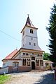
The church of Sf. Nicolae

View of Turnu Roșu, picture by Franz Neuhauser


Web links
Individual evidence
- ↑ a b 2011 census in Romania ( MS Excel ; 1.3 MB)
- ↑ a b Heinz Heltmann, Gustav Servatius (Ed.): Travel Guide Siebenbürgen. Kraft, Würzburg 1993, ISBN 3-8083-2019-2 .
- ↑ Institute Of Archeology - Porceşti , accessed on September 4, 2015 (Romanian).
- ↑ Turnu Roșu, Prezentare (information on the history of the community). In: Prezentarea comunei. www.turnurosu.ro, 2007, accessed January 24, 2020 (Romanian). .
- ↑ Census, last updated November 4, 2008 (Hungarian; PDF; 1.1 MB).
- ↑ Information on the church at turnurosu.ro accessed on September 4, 2015 (Romanian).
- ↑ a b c List of historical monuments of the Romanian Ministry of Culture, updated 2010 (PDF; 7.10 MB).
- ↑ Information on nature reserves of the Romanian Parliament .
- ↑ Information on turnurosu.ro accessed on September 4, 2015 (Romanian).

Alma | Alțâna | Apoldu de Jos | Arpașu de Jos | Ațel | Axente Sever | Bârghiș | Bazna | Biertan | Blăjel | Boița | Brădeni | Brateiu | Bruiu | Cârța | Cârțișoara | Chirpăr | Cristian | Dârlos | Gura Râului | Hoghilag | Iacobeni | Jina | Laslea | Loamneș | Ludoș | Marpod | Merghindeal | Micăsasa | Mihăileni | Moșna | Nocrich | Orlat | Păuca | Poiana Sibiului | Poplaca | Porumbacu de Jos | Racovița | Rășinari | Râu Sadului | Roșia | Sadu | Șeica Mare | Șeica Mică | Șelimbăr | Slimnic | Șura Mare | Șura Mică | Târnava | Tilișca | Turnu Roșu | Valea Viilor | Vurpăr