
Slimnic
|
Slimnic Stolzenburg Szelindek |
|||||
|
|||||
| Basic data | |||||
|---|---|---|---|---|---|
| State : |
|
||||
| Historical region : | Transylvania | ||||
| Circle : | Sibiu | ||||
| Coordinates : | 45 ° 55 ' N , 24 ° 10' E | ||||
| Time zone : | EET ( UTC +2) | ||||
| Height : | 439 m | ||||
| Area : | 106.24 km² | ||||
| Residents : | 3,581 (October 20, 2011) | ||||
| Population density : | 34 inhabitants per km² | ||||
| Postal code : | 557240 | ||||
| Telephone code : | (+40) 02 69 | ||||
| License plate : | SB | ||||
| Structure and administration (as of 2016) | |||||
| Community type : | local community | ||||
| Structure : | Slimnic, Albi , Pădureni , Ruși , Veseud | ||||
| Mayor : | Ioan Șurean ( PNL ) | ||||
| Postal address : | Str. Principală, No. 6 loc. Slimnic, jud. Sibiu RO-557240 |
||||
| Website : | |||||


Slimnic (outdated Slâmnic ; German Stolzenburg , Hungarian Szelindek ) is a municipality in the Sibiu district in Transylvania , Romania .
The place is also known under the Hungarian name Nagyszelindek .
Geographical location

Slimnic is located on the Zibins level, at the transition from the “Hafner” to the “Weinland”, in the Altland of Transylvania. On the national road ( Drum național ) DN 14 ( Sibiu - Mediaș ) the community is about 18 kilometers north of the district capital Sibiu ( Hermannstadt ).
history
On the territory of the municipality, called Cetățeaua by the locals , archeological excavations have found objects that indicate settlement in the Bronze Age ; at Șarba - La Saivane and Șarba - Stempen ("Schelzenthal") references to settlements from Roman times were discovered.
The place founded by Transylvanian Saxons was first mentioned in a document in 1282. In 1394 the school of the Transylvanian Saxons was declared under the direction of the then headmaster Allexius - who was also the local notary . From the 15th to the 19th century, Stolzenburg was one of the largest communities in the Sibiu area.
In connection with the events of the revolution of 1848/49 , the place and castle gained importance when Józef Bem met with the Hungarian revolutionary army in Stolzenburg on the imperial troops under Field Marshal Lieutenant Puchner .
The main occupations of the population are agriculture and livestock. Small iron-processing crafts such as blacksmithing played an important role in Stolzenburg. As a result, the horseshoe - carried through rings - represents the coat of arms of the community.
population
The population of the municipality developed as follows:
| census | Ethnic composition | |||||||
|---|---|---|---|---|---|---|---|---|
| year | population | Romanians | Hungary | German | other | |||
| 1850 | 3,995 | 1,888 | 54 | 1,662 | 391 | |||
| 1900 | 4,661 | 2,637 | 91 | 1.929 | 4th | |||
| 1941 | 5,851 | 3,235 | 18th | 2,593 | 5 | |||
| 1977 | 5,641 | 3,483 | 11 | 2,026 | 121 | |||
| 1992 | 3,683 | 3,480 | 20th | 171 | 12 | |||
| 2002 | 3,670 | 3,590 | 20th | 44 | 16 | |||
| 2011 | 3,581 | 3,356 | 17th | 33 | 175 | |||
The highest population of today's municipality - and at the same time that of the Germans - was determined in 1941. The highest population of Romanians was registered in 2002, Hungarians (91) 1900 and Roma (391) 1850. In addition, in 1880 and 1966, one resident called himself a Slovak .
In Slimnic itself, the number of inhabitants rose steadily from 1850 (in equal parts Germans and Romanians, each approx. 1,000 inhabitants) until 1941 (Germans 1,806; Romanians 1,938). After 1989 - since the mass emigration of the Transylvanian Saxons - almost all Romanians live in Slimnic, along with Germans, Hungarians and Roma, each about 1%.
Attractions
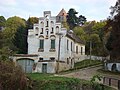
- The castle ruins of the Fliehburg on a mountain above the village, built in the 15th century by the Transylvanian Saxons . The castle, with the high brick walls with double loopholes, was built around an unfinished Gothic hall church - a square in the north, a triangular castle with a courtyard in the south - and is a listed building.
- Evangelical village church, a Gothic hall church built in the 14th century, is a listed building. Its protective wall (also around the Protestant rectory) was torn down by the Kuruc in 1706 .
- The Romanian Orthodox Church Sf. Arhangheli , built in 1831 (expanded 1889–1910), is a listed building. The church was badly damaged by the flood (1975) and the earthquake of 1977 .
- The Greek Catholic Church Sf. Treime , built 1904–1910 on the plan of an older church. Due to a landslide caused by floods and earthquakes, it was closed in 1981.
- Second Orthodox Church, under construction since 1991.

View of Stolzenburg
The rectory
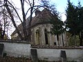
Evangelical village church

New Orthodox Church

Castle ruins of the peasant castle
.jpg)
.JPG)
.JPG)
.JPG)
.JPG)
Personalities
- Johann Bergleiter (1774–1843), was a Protestant bishop in Transylvania from 1833 to 1843 , previously pastor in Stolzenburg from 1811 to 1833 .
- Johann Plattner (1854–1942), pastor, writer and local chronicler.
- Walter Gottfried Seidner (1938–2018), writer , pastor from 1982 to 2008, lived in Stolzenburg
- Thomas Nägler (1939–2011), historian , born in Stolzenburg
Web links
- Slimnic at ghidulprimariilor.ro
- Stolzenburg at sevenbuerger.de
- Information on Slimnic's Earlier History (Romanian)
- E. Kanz, O. Rothbächer: Church and festival costume from Stolzenburg / Transylvania (PDF; 7.40 MB)
- Stolzenburg, private website of Reinhardt Linder
Individual evidence
- ↑ 2011 census in Romania at citypopulation.de
- ^ Dictionary of the localities in Transylvania
- ↑ a b c d List of historical monuments of the Romanian Ministry of Culture, updated 2010, accessed on February 5, 2013 (PDF; 7.10 MB)
- ^ Institute Of Archeology - Slimnic, accessed May 26, 2010 (Romanian)
- ↑ a b c Website of the municipality of Slimnic ( Memento from June 3, 2010 in the Internet Archive ) (Romanian)
- ^ Image of the coat of arms, at the Stolzenburg town hall
- ↑ Census, last updated November 4, 2008, p. 68 (Hungarian; PDF; 596 kB)
- ↑ a b Heinz Heltmann, Gustav Servatius (Ed.): Travel Guide Siebenbürgen. Kraft, Würzburg 1993, ISBN 3-8083-2019-2 , p. 138.
- ↑ Georg Daniel Teutsch: mountain guide, Johann . In: Allgemeine Deutsche Biographie (ADB). Volume 2, Duncker & Humblot, Leipzig 1875, p. 389 f.
- ↑ H. Stanescu: Plattner, Johann (1854-1942), writer, pastor and teacher. In: Austrian Biographical Lexicon 1815–1950 (ÖBL). Volume 8, Verlag der Österreichischen Akademie der Wissenschaften, Vienna 1983, ISBN 3-7001-0187-2 , p. 119 f. (Direct links on p. 119 , p. 120 ).
- ↑ Walter Seidner: "On cloud seven / Bürgen", on sevenbuerger.de/zeitung
- ↑ Thomas Nägler: a historian who helped shape history, on sevenbuerger.de/zeitung

Alma | Alțâna | Apoldu de Jos | Arpașu de Jos | Ațel | Axente Sever | Bârghiș | Bazna | Biertan | Blăjel | Boița | Brădeni | Brateiu | Bruiu | Cârța | Cârțișoara | Chirpăr | Cristian | Dârlos | Gura Râului | Hoghilag | Iacobeni | Jina | Laslea | Loamneș | Ludoș | Marpod | Merghindeal | Micăsasa | Mihăileni | Moșna | Nocrich | Orlat | Păuca | Poiana Sibiului | Poplaca | Porumbacu de Jos | Racovița | Rășinari | Râu Sadului | Roșia | Sadu | Șeica Mare | Șeica Mică | Șelimbăr | Slimnic | Șura Mare | Șura Mică | Târnava | Tilișca | Turnu Roșu | Valea Viilor | Vurpăr