
Vergato
| Vergato | ||
|---|---|---|

|
|
|
| Country | Italy | |
| region | Emilia-Romagna | |
| Metropolitan city | Bologna (BO) | |
| Local name | Varghè / Vergà | |
| Coordinates | 44 ° 17 ' N , 11 ° 7' E | |
| height | 193 m slm | |
| surface | 59 km² | |
| Residents | 7,736 (Dec. 31, 2019) | |
| Population density | 131 inhabitants / km² | |
| Post Code | 40038 | |
| prefix | 051 | |
| ISTAT number | 037059 | |
| Website | www.comune.vergato.bo.it/ | |

Vergato is an Italian commune ( comune ) with 7736 inhabitants (as of December 31, 2019) in the metropolitan city of Bologna , Emilia-Romagna region .
geography
The main town is in the lowlands of the Reno valley at 193 m slm in the Tuscan-Emilian Apennines on the border with the nearby Po plain .
history
The rulers of Frignano ruled the area around Vergato until around 1000. With the death of Mathilde of Tuscia , the area was ceded to the municipality of Bologna.
After many vicissitudes, Vergato gradually became the most important capital in the area. At the beginning of the 15th century it was the seat of the Capitanato della Montagna (an administrative district in the vicinity of Bologna, on which the entire mountainous landscape around Bologna depended). The former government palace has now been converted into the town hall.
During the Second World War, from 1944 onwards, the area around Vergato was one of the many centers of resistance in the Tuscan-Emilian Apennines. After the reprisals perpetrated by the Germans on Monte Sole, better known as the Marzabotto massacre, only a few kilometers northeast of Vergato, Vergato was evacuated by the Wehrmacht in October 1944 and was located in the immediate vicinity of the Goths . During the Allied spring offensive in 1945, a fierce house-to-house war broke out in April 1945, and a large part of Vergato's historical building fabric was lost.
In 2002 the municipality of Vergato was awarded the gold medal for civil service by President Carlo Azeglio Ciampi for the sacrifices made in the Second World War .
Administrative division
The municipality of Vergato includes, in addition to the main town Vergato with the municipality seat, the seven fractions : Calvenzano, Castelnuovo, Pieve Roffeno, Prunarolo, Riola, Susano and Tolè Cereglio.
Places and sights
Many of the towns and hamlets in the area are historically and culturally significant. Among these is Calvenzano, an old village that already existed in the year 1000 and in particular its church of Madonna del Bosco (Our Lady in the Forest). Another important town is Sanguineta.
Pieve di Roffeno, today a small, remote and not so well developed hamlet, played a very important role in the Middle Ages because of its church. The parish church, from 1155, is one of the most interesting in the Apennines. The apse and parts of the boundary walls belong to the original Romanesque building.
Worth seeing are Casa Berti in Prunarolo with its tower from the 16th century; the church of Santa Maria Assunta in the Riola district, designed by the famous Finnish architect Alvar Aalto , the medieval fortresses of Costonzo and Monzone (8th-14th centuries) near Montecavalloro; Casa Laffi in Tolè, a building from the 16th century with a pigeon-catching tower and La Torre (The Tower), an old administrative palace that dates back to the 14th to 15th centuries.
traffic
Vergato has a train station on the Pistoia – Bologna railway line . Strada Statale 64 Porrettana , which connects Pistoia with Ferrara , runs through the municipality .
Personalities
- Alfonso Calzolari (1887–1983), Italian racing cyclist

Abandoned Church of San Giorgio in Montecavalloro

Event in front of the Palazzo dei Capitani

Interior of the parish church of Riola designed by Alvar Aalto

Romanesque Pieve in San Pietro a Roffeno (Photo by Paolo Monti )
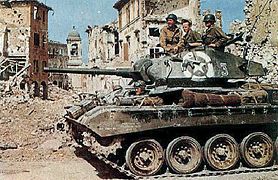
US tanks in the destroyed Vergato in April 1945
_-_panoramio_-_Carlo_Pelagalli.jpg)


_-_BEIC_6332582.jpg)

Web links
Individual evidence
- ↑ Statistiche demografiche ISTAT. Monthly population statistics of the Istituto Nazionale di Statistica , as of December 31 of 2019.
- ↑ Vergato. In: storiaememoriadibologna.it. Retrieved January 17, 2020 (Italian).
- ^ Vergato medaglia d'oro al merito civile riceve Carlo Azeglio Ciampi. In: vergatonews24.it. April 23, 2014, accessed January 17, 2020 (Italian).
- ↑ Municipal Statute (Italian) (PDF; 137 kB), accessed on January 17, 2020.

Alto Reno Terme | Anzola dell'Emilia | Argelato | Baricella | Bentivoglio | Bologna | Borgo Tossignano | Budrio | Calderara di Reno | Camugnano | Casalecchio di Reno | Casalfiumanese | Castel d'Aiano | Castel del Rio | Castel di Casio | Castel Guelfo di Bologna | Castel Maggiore | Castel San Pietro Terme | Castello d'Argile | Castenaso | Castiglione dei Pepoli | Crevalcore | Dozza | Fontanelice | Gaggio Montano | Galliera | Granarolo dell'Emilia | Grizzana Morandi | Imola | Lizzano in Belvedere | Loiano | Malalbergo | Marzabotto | Medicina | Minerbio | Molinella | Monghidoro | Monte San Pietro | Monterenzio | Monzuno | Mordano | Ozzano dell'Emilia | Pianoro | Pieve di Cento | Sala Bolognese | San Benedetto Val di Sambro | San Giorgio di Piano | San Giovanni in Persiceto | San Lazzaro di Savena | San Pietro in Casale | Sant'Agata Bolognese | Sasso Marconi | Valsamoggia | Vergato | Zola Predosa