Alamosa County
 Alamosa County Courthouse |
|
| administration | |
|---|---|
| US state : | Colorado |
| Administrative headquarters : | Alamosa |
| Address of the administrative headquarters: |
PO Box 178 Alamosa, CO 81101-0178 |
| Foundation : | March 8, 1913 |
| Demographics | |
| Residents : | 15,445 (2010) |
| Population density : | 8.3 inhabitants / km 2 |
| geography | |
| Total area : | 1874 km² |
| Water surface : | 2 km² |
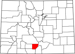
| map | |
| Website : www.alamosa.org | |
Alamosa County is an administrative unit ( county ) in the southern part of the US state of Colorado in a sparsely populated region in the San Luis Valley . The capital is Alamosa .
Places and neighboring counties
The capital Alamosa with 8,780 inhabitants (2010) and the directly adjacent Alamosa East with 1,458 inhabitants together are home to two thirds of all residents of Alamosa County. Both are connected by a bridge over the Rio Grande .
Lead as seen from Alamosa
- south of US Highway 285 via La Fruto , Henry , Hartner and Estrella into adjacent Conejos County and on to New Mexico ,
- southwest a local road as a junction of Highway 285 to Waverly ,
- east of US Highway 160 into the two neighboring counties of Costilla County and Huerfano County ,
- west of both highways together to Monte Vista in Rio Grande County and
- north a road through Mosca and Hooper in adjacent Saguache County .
Demographic data
| growth of population | |||
|---|---|---|---|
| Census | Residents | ± in% | |
| 1920 | 5148 | - | |
| 1930 | 8602 | 67.1% | |
| 1940 | 10,484 | 21.9% | |
| 1950 | 10,531 | 0.4% | |
| 1960 | 10,000 | -5% | |
| 1970 | 11,422 | 14.2% | |
| 1980 | 11,799 | 3.3% | |
| 1990 | 13,617 | 15.4% | |
| 2000 | 14,966 | 9.9% | |
| 2010 | 15,455 | 3.3% | |
| 1920–1990 2000 2010 | |||

As of the 2000 census , the county had 14,966 people. There were 5,467 households and 3,651 families. The population density was 8 people per square kilometer. The racial the population was composed of 71.19 percent white, 0.97 percent African American, 2.34 percent Native American, 0.82 percent Asian, 0.19 percent of residents from the Pacific island area and 20.34 percent from other ethnic groups Groups; 4.16 percent were descended from two or more races. Hispanic or Latino of any race was 41.41 percent of the population.
Of the 5,467 households, 35.3 percent had children and young people under the age of 18 living with them. 50.5 percent were married couples living together, 11.7 percent were single mothers. 33.2 percent were not families. 27.3 percent were single households and 8.7 percent had people aged 65 years or over. The average household size was 2.56 and the average family size was 3.14.
For the entire county, the population was composed of 27.2 percent of residents under the age of 18, 15.9 percent between 18 and 24 years of age, 26.7 percent between 25 and 44 years of age, and 20.6 percent between 45 and 64 years of age 9.6 percent were 65 years of age or over. The median age was 31 years. For every 100 females there were 99.0 males, and for every 100 females aged 18 and over there were 95.3 males.
The median income for a household in the 29,447 USD , and the median income for a family was 38,389 USD. Males had a median income of $ 27,733 versus $ 22,806 for females. The per capita income was $ 15,037. 21.3 percent of the population and 15.6 percent of families are below the poverty line. This included 27.4 percent of the population under the age of 18 and 13.9 percent of the population aged 65 and over.
Individual evidence
- ↑ GNIS-ID: 198117. Retrieved on February 22, 2011 (English).
- ↑ Official results of the 2010 census
- ↑ Extract from Census.gov . Retrieved February 14, 2011
- ↑ census.gov (2000) ( Memento from May 22, 2012 in the Internet Archive ) ( MS Excel ; 26 kB) Retrieved on March 31, 2012
- ^ Extract from census.gov.Retrieved March 31, 2012
Web links
Coordinates: 37 ° 34 ′ N , 105 ° 47 ′ W

