Silesian Voivodeship
|
|||
| map | |||
|---|---|---|---|
| Coat of arms and logo | |||
| ( Coat of arms, flag and logo ) | |||
| Basic data | |||
| Capital : | Katowice | ||
| Voivode : | Jarosław Wieczorek | ||
| Voivodeship Marshal : | Jakub Chełstowski | ||
| Biggest town: | Katowice | ||
| ISO 3166-2 : | PL-24 | ||
| Residents : | 4,617,000 (March 31, 2011) | ||
| Population density : | 381 inhabitants per km² | ||
| geography | |||
| Area : | 12,294 km² | ||
| - of which country: | ? km² | ||
| - of which water: | ? km² | ||
| Expansion: | North-South: up to 188 km West-East: up to 107 km |
||
| The highest point: | 1365 m | ||
| Deepest point: | 180 m | ||
| Landscape structure | |||
| Forests: | 31.7% | ||
| Waters: | ? % | ||
| Agriculture: | ? % | ||
| Other: | ? % | ||
| Administrative division | |||
| Independent cities : | 19th | ||
| Counties : | 17th | ||
| Municipalities : | 166 | ||


The Silesian Voivodeship ( Polish Województwo śląskie ) with the capital Katowice (Kattowitz) is one of the 16 voivodships of the Republic of Poland . It emerged during the territorial reform in 1999 from the Katowice , Częstochowa and Bielsko-Biała Voivodeships and occupies the central-southern part of Poland. With around 4.7 million inhabitants on 12,294 km², Silesia is the most densely populated voivodeship. The metropolitan area around the cities of Katowice and Gliwice emerged as a result of the coal mining industry in the 19th century .
The Silesian Voivodeship includes parts of the historical regions of Silesia (Prussian Province of Upper Silesia and Cieszyn Silesia ) and Lesser Poland (and thus the Dombrowa coal basin and Galicia ).
The name of the voivodeship goes back to the Autonomous Voivodeship of Silesia . The Autonomous Voivodeship of Silesia consisted of only a part of Upper Silesia (see the map of the development of the borders of the Silesian Voivodeship), which means that a distinction between Upper Silesia and Lower Silesia in the name was not necessary.
coat of arms
Description : A completely golden eagle in blue .
geography
location
The Silesian Voivodeship, which in its borders does not coincide with the geographical regions of Silesia or the Autonomous Silesian Voivodeship, occupies the central-southern part of Poland . In their upper courses the Oder , Vistula and Warta flow through this voivodeship. It borders on the Voivodships Opole , Łódź , Heiligkreuz , Lesser Poland and in the south on the Czech Republic and Slovakia .
Biggest cities
| city | German name | Residents June 30, 2015 |
|---|---|---|
| Katowice | Katowice | 300,797 |
| Czestochowa | Czestochowa | 229.086 |
| Sosnowiec | Sosnowitz | 208,321 |
| Gliwice | Gliwice | 183.970 |
| Zabrze | Hindenburg OS | 176,825 |
| Bielsko-Biała | Bielitz-Biala | 172.781 |
| Bytom | Beuthen OS | 171,515 |
| Ruda Śląska | Ruda OS | 140.212 |
| Rybnik | Rybnik | 139,866 |
| Tychy | Tichau | 128,480 |
| Dąbrowa Górnicza | Dombrowa | 122.923 |
| Chorzów | Koenigshütte | 110.125 |
| Jaworzno | Jaworzno | 93,076 |
| Jastrzębie-Zdrój | Bad Königsdorff-Jastrzemb | 90,549 |
| Mysłowice | Myslowitz | 75.019 |
| Siemianowice Śląskie | Laurahütte (Siemianowitz) | 68,411 |
| Żory | Sohrau | 61,985 |
| Tarnowskie Góry | Tarnowitz | 60,924 |
| Będzin | Bendzin | 58.102 |
| Piekary Śląskie | German Piekar | 56,588 |
| Racibórz | Ratibor | 55,547 |
| Świętochłowice | Schwientochlowitz | 51,299 |
| Zawiercie | Zawiercie | 50,809 |
Rivers
Economy and Transport
In comparison with the GDP of the EU , as measured by the purchasing power standard , the province reached 2015, an index of 71 (EU-28 = 100). In the course of structural change and the decline of heavy industry , the number of unemployed rose sharply , especially in the secondary sector . In recent years, however, new jobs have been created in other economic sectors, which is why the unemployment rate has fallen significantly. After the Masovian and Greater Poland Voivodeships , it has the lowest unemployment rate in Poland (as of December 2009).
- 16.9% (December 31, 2004)
- 15.2% (April 30, 2006)
- 11.7% (April 30, 2007)
- 8.2% (April 30, 2008)
- 9.2% (December 2009)
- 11.3% (December 2013)
- 8.2% (December 2015)
In 2017 the unemployment rate (according to Eurostat definition) was 3.9%.
With a value of 0.849, Silesia ranks 5th among the 16 Voivodeships of Poland in the Human Development Index .
Industry
Hard coal mining , iron and heavy metal smelters, electrical industry, mechanical engineering and the automotive industry are the main branches of the industry located here. The Silesian Voivodeship is the most industrialized part of Poland.
Natural resources
- Hard coal
- Iron, zinc and lead ores
Highways
The A4 ( Breslau - Upper Silesia - Cracow ) runs right through the Silesian Voivodeship, from west to east, and the planned A1 motorway from north to south .
Rail transport
The operator of the rail network in Poland is PKP SA (Polish State Railway Company). The largest rail hub in the voivodeship is in Katowice.
Airports
Katowice International Airport is located on the outskirts of the voivodeship capital .
tourism
A large part of the voivodeship is made up of low mountain ranges, with the hilly terrain in the south merging into the Beskids , a tourist region with winter sports resorts such as Szczyrk , Ustroń , Wisła . The mountains of the Kraków-Częstochowa Jura are also popular with hikers and climbers , but they are also known for their historic castle ruins from the 14th and 15th centuries, which are accessible to tourists through the Szlak Orlich Gniazd (the Eagle's Nest Route ).
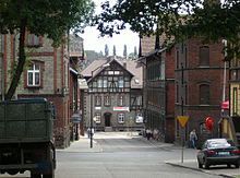
The industrial heritage of the region is being developed more and more for tourism. The route of technical cultural monuments leads to interesting industrial monuments.
politics
In the Silesian Voivodeship there is an elected voivodship seymik and voivodeship marshal and a government-appointed voivod.
Voivodeship Seemik
Since the 2018 election, the Voivodship Sejmik has been composed as follows:
| Election committee | Mandates |
|---|---|
| Citizens Platform (PO) |
20/45 |
| Law and Justice (PiS) |
22/45 |
| Polish People's Party (PSL) |
1/45 |
| Movement for the Autonomy of Silesia (RAŚ) |
0/45 |
| Federation of the Democratic Left (SLD) |
1/45 |
Voivodeship Marshal
Jakub Chełstowski ( PiS ) has been Voivodeship Marshal since 2018 .
Administrative division
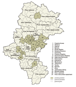
The Silesian Voivodeship is subdivided into 17 districts, with 19 cities remaining independent. Some of them also form a district under their name, but do not belong to it themselves.
| One district cities | ||
|---|---|---|
|
|
|
| Counties | ||
|
|
|
(Resident on June 30, 2006)
See also
Web links
- Silesian Voivodeship Office (Polish)
- Tourist information - Silesian Voivodeship (German)
- Information on the Silesian Voivodeship (German)
Individual evidence
- ^ Result of the 2011 census, Główny Urząd Statystyczny: Wyniki Narodowego Spisu Powszechnego Ludności i Mieszkań 2011. Warsaw, March 2012. Online ( Memento from January 16, 2013 in the Internet Archive ) (PDF)
- ↑ Eurostat. Retrieved April 15, 2018 .
- ^ Polish Statistical Office ( Memento of June 27, 2008 in the Internet Archive ) (PDF)
- ↑ Central Statistics Office of Poland (CIS), Bezrobotni oraz stopa bezrobocia wg województw, grudzień 2009 , February 3, 2010 ( Memento from April 2, 2015 in the Internet Archive )
- ↑ Central Statistics Office of Poland (CIS)
- ↑ Unemployment rate, by NUTS 2 regions. Retrieved November 5, 2018 .
- ^ Sub-national HDI - Area Database - Global Data Lab. Retrieved August 12, 2018 .
- ↑ bip.slaskie.pl
Coordinates: 50 ° 20 ′ N , 19 ° 0 ′ E


