Altenmarkt an der Alz
| coat of arms | Germany map | |
|---|---|---|

|
Coordinates: 48 ° 0 ' N , 12 ° 32' E |
|
| Basic data | ||
| State : | Bavaria | |
| Administrative region : | Upper Bavaria | |
| County : | Traunstein | |
| Height : | 499 m above sea level NHN | |
| Area : | 26.11 km 2 | |
| Residents: | 4146 (Dec. 31, 2019) | |
| Population density : | 159 inhabitants per km 2 | |
| Postal code : | 83352 | |
| Area code : | 08621 | |
| License plate : | TS, LF | |
| Community key : | 09 1 89 111 | |
| Community structure: | 42 districts | |
| Address of the municipal administration: |
Hauptstrasse 21 83352 Altenmarkt adAlz |
|
| Website : | ||
| First Mayor : | Stephan Bierschneider (CSU) | |
| Location of the municipality Altenmarkt adAlz in the district of Traunstein | ||
Altenmarkt an der Alz (officially: Altenmarkt adAlz ) is a municipality in the Upper Bavarian district of Traunstein . It owes its name affix to the Alz , an outflow of the Chiemsee and a tributary of the Inn , which flows through the municipality.
geography
Altenmarkt is located at the confluence of the Alz and Traun rivers . Distance to the district town of Traunstein about 18 kilometers, to the state capital Munich about 82 kilometers, to Landshut about 91 kilometers, to Passau about 115 kilometers.
Community structure
There are 42 officially named districts:
|
history
Until the church is planted
The place Altenmarkt an der Alz got its name after the foundation of the "new" market Trostberg, which is located in the immediate north about 750 years ago. For centuries it was a small craft settlement at the foot of the Baumburg monastery . In addition, Altenmarkt was important due to its location at the crossing over the Alz, where the place served the function of a customs and trading center. The place was part of the Electorate of Bavaria and formed a closed Hofmark of the monastery. The manorial rule of the Baumburg monastery ended around 1803 . In the course of the administrative reforms in Bavaria , the municipal edict of 1818 created the independent political municipality.
Incorporations
The municipality of Rabenden lost its independence in the course of the municipal reform and was incorporated on January 1, 1975.
Population development
Between 1988 and 2018 the municipality grew from 3,178 to 4,181 by 1,003 inhabitants or by 31.6%.
- 1961: 3349 inhabitants
- 1970: 3313 inhabitants
- 1987: 3151 inhabitants
- 1991: 3371 inhabitants
- 1995: 3739 inhabitants
- 2000: 3970 inhabitants
- 2005: 4257 inhabitants
- 2010: 4297 inhabitants
- 2015: 4181 inhabitants
politics
Municipal council
The municipal council has 16 members. Another member and chairman of the municipal council is the mayor. In the local elections on March 15, 2020, 2,178 of the 3,405 residents eligible to vote in the municipality of Altenmarkt an der Alz exercised their right to vote, bringing the turnout to 63.96%.
The mandates in the municipal council for the term 2020 to 2026 are distributed as follows:
- CSU : 6 seats (39.72%)
- FREE VOTERS : 7 seats (44.37%)
- SPD : 3 seats (15.91%).
mayor
Stephan Bierschneider has been mayor since May 1, 2008. In the local election on March 15, 2020, he was elected with 55.43% of the vote.
coat of arms
Blazon : Above, in red on a green three-mountain, a golden castle with two crenellated towers and an open gate, through which the trunk of a green linden tree spreading over the gate can be seen. Below in the green field crossed by a silver river that divides in the shape of a drawbar, crossed diagonally a Roman standard, which is decorated with a golden hand of oath and a golden bundle of fascia with the lictor's ax; in the upper corner formed by this sits on one with “S. P. Q. R. "marked a golden Roman legionary eagle, on both sides of which the letters L and VII.
Culture and sights
The legendary Café Libella has been in town since 1989 .
Architectural monuments
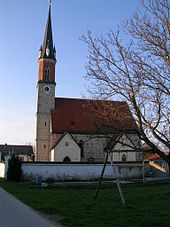
- Filial church of St. Giles in Altenmarkt
- Baumburg Monastery : building of the former Augustinian choir monastery
- Parish Church of St. Margareta (former monastery church)
- late Gothic church of St. Peter and Paul in Kirchberg
- late Gothic church of St. James the Elder in the Rabenden district with the altar of the master of Rabenden
- Romanesque, later Baroque-style pilgrimage church of St. Wolfgang in the St. Wolfgang district
Soil monuments
See: List of ground monuments in Altenmarkt an der Alz
Buchenwald memorial
A memorial for soldiers from different eras, known as the Buchenwald memorial , is located in the village to the west of the Baumburg monastery on a mountain slope . The memorial is located near the Altenmarkt cemetery.
The memorial was initially created over a mass grave in which Bavarian, Austrian and French soldiers who died of epidemics at the Battle of Hohenlinden (December 1800) were buried. The Canons' Monastery of Baumburg was used as a military hospital, to which the wounded from all the armies involved had fled. According to tradition, more than 2,000 soldiers died as a result of a typhus epidemic. They were buried in a mass grave in the nearby beech forest. Due to the prevailing confusion, the dead were neither counted nor recorded, so it is unclear how many dead and who were buried in the grave. In order to keep the memory of this grave alive, a memorial chapel in neo-Romanesque style was built in 1849 "on a hill" above the mass grave. Furthermore, memorial stones for those who fell in the war of 1870/71 were erected at the chapel . Memorial crosses were also erected for the dead of the First and Second World Wars in the community. Every year in June, the so-called Buchenwald commemoration takes place at the memorial .
Economy and Infrastructure
Economy including agriculture and forestry
In addition to smaller craft businesses and tourism, the company ALZMETALL , which was founded in 1945 - machine tool factory and foundry - is an important employer in Altenmarkt.
In 1998, according to official statistics, there were five in the field of agriculture and forestry, 688 in the manufacturing sector and 172 in the trade and transport sector at the place of work. In other economic areas 232 people were employed at the place of work subject to social security contributions. There were a total of 1338 employees at the place of residence subject to social security contributions. There was one company in the manufacturing sector and three companies in the construction sector. In addition, in 1999 there were 60 farms with an agriculturally used area of 1573 ha, of which 1171 ha were arable land and 402 ha were permanent green space.
traffic
- Altenmarkt is the starting point of the federal road 299 , which has a connection to the B 304 .
- Traun-Alz Railway
education
There are the following institutions (status: 2014):
- two kindergartens: parish kindergarten with 49 children and “Traunspatz'n” with 79 children
- a primary and middle school with 228 students
Personalities
- Franz Xaver Kroetz (* 1946), director, writer, playwright and actor
- Helmut Josef Geier (* 1962), known as DJ Hell
See also
Web links
- Homepage
- Entry on the coat of arms of Altenmarkt an der Alz in the database of the House of Bavarian History
Individual evidence
- ↑ "Data 2" sheet, Statistical Report A1200C 202041 Population of the municipalities, districts and administrative districts 1st quarter 2020 (population based on the 2011 census) ( help ).
- ↑ Bavarian State Ministry for Digital: BayernPortal: Altenmarkt an der Alz municipality. Retrieved May 13, 2020 .
- ↑ http://www.bayerische-landesbibliothek-online.de/orte/ortssuche_action.html ? Anzeige=voll&modus=automat&tempus=+20111108/171531&attr=OBJ&val= 549
- ^ Federal Statistical Office (ed.): Historical municipality directory for the Federal Republic of Germany. Name, border and key number changes for municipalities, counties and administrative districts from May 27, 1970 to December 31, 1982 . W. Kohlhammer GmbH, Stuttgart / Mainz 1983, ISBN 3-17-003263-1 , p. 593 .
- ↑ Results of local elections 2020. OK.VOTE, March 15, 2020, accessed on May 24, 2020 .
- ↑ Results of local elections 2020. OK.VOTE, March 15, 2020, accessed on May 24, 2020 .
- ↑ Results of local elections 2020. OK.VOTE, March 15, 2020, accessed on May 24, 2020 .
- ↑ see The Buchenwald commemoration ( memento of the original from September 26, 2015 in the Internet Archive ) Info: The archive link was automatically inserted and has not yet been checked. Please check the original and archive link according to the instructions and then remove this notice. Page on the municipality's website, accessed on September 26, 2015
- ↑ Municipality of Altenmarkt: Facts and Figures ( Memento of the original from October 10, 2014 in the Internet Archive ) Info: The archive link was inserted automatically and has not yet been checked. Please check the original and archive link according to the instructions and then remove this notice.


