
Beacon supergroup

The Beacon Supergroup (from English beacon , lighthouse, signal fire , Germanized also Beacon supergroup ) is a lithostratigraphic rock unit made up of mainly terrestrial sandstone-related sediments in the continent of Antarctica . The mighty deposit sequences form a widespread overburden on basement units of West and East Antarctica .
The deposition period ranges from the Devonian around 400 mya to the early Jurassic around 180 mya.
Numerous body and trace fossils are contained in sandstone layers. The therapside Lystrosaurus and the seed fern Glossopteris from the Glossopteris flora are of particular importance . They have been found on many continents and support the theory of plate tectonics and the reconstruction of the great continent of Gondwana .
Naming
The name was coined by the Scottish polar explorer Albert Armitage , who took part in the Discovery Expedition (1901-1904) under Robert Falcon Scott . From this term the name for the Beacon Heights , a small group of mountain peaks with a height of 2,345 meters between the Beacon Valley and the Arena Valley in the Quartermain Mountains in East Antarctica Victoria Land , is derived.
Occurrence
The Beacon Supergroup was mostly deposited on the eroded hull surface of the Ross orogen . Outcrops are emerging today in the Transantarctic Mountains from East Antarctic Victoria Land to the Pensacola Mountains in West Antarctic Queen Elizabeth Land , in George V Land , on the eastern edge of the Shackleton Range , north and south of the Shackleton Range in the Theron Mountains and the Whichaway- Nunatakkern , in western Queen Maud Land , in the Ellsworth Mountains and in the Lambert Glacier area in Mac Robertson Land .
Rocks and sedimentation

Cross-layered sandstones in the Beacon Supergroup
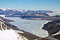
Aerial photograph of Beacon Supergroup in the Taylor Valley of Victoria Land with diabase - or dolerite - sills

The Beacon Supergroup forms a sequence of deposits up to 4 kilometers thick, which mainly sedimented on flat basement units with low reliefs. The lithostratigraphy of this supergroup is divided into several groups and formations .
The main rocks are fluvial, coarse to fine-grained arkosan , quartzitic - sandstones and quartzites . There are also silts , mud rocks , various conglomerates and local thin-layer limestone layers .
The different sorting and rounding of the rock grains document a different length of transport through flowing waters and thus also a predominantly terrestrial environment for the period from Devon to the Lower Jurassic . The sedimentation took place mainly in marine shallow water environments with a low to high wave energy influence , which is documented by ripple marks and cross stratifications .
Multiple rose powerful, up to 1000 meters thick diabase / dolerite - sills , which covered the previously deposited layers or invading them and thereby usually followed bedding planes. Volcanic lapilli , tuffs , ashes and coarse volcanic breccias are evidence of explosive volcanism . These processes were caused by an incipient tectonic expansion regime, which continued until the early Jurassic. Among other things, they led to low-grade thermal metamorphosis of the sediment layers.
Special features form Permo-Carboniferous tillites and Diamictites in combination with glacial striae and Permian coal seams . These point to a rapid paleoclimatic change from cold-age or cold conditions to humid conditions with milder temperatures and thick forest.
The Beacon Supergroup corresponds to the lower Gondvana layers of India and South America , the Karoo supergroup of southern Africa and the Permo-Triassic analogues in Australia .
Fossils
Various fossils of ancient life forms have been preserved in the sandstone layers , such as B. Body fossils of animals and plants as well as trace fossils of eating, digging and crawling animals.

Paleobiogeographical distribution areas of Cynognathus , Mesosaurus , Glossopteris flora and Lystrosaurus at the time of Gondwana

Lystrosaurus georgi skeleton

Informal example of Phyllolepida

Informal example of various Thelodonti representatives

Informal example of several Estherias ( mussel shells )

Informal example of Glossopteris spec.

Dicroidium leaf , found in the South African Karoo supergroup , also corresponds to the Antarctic Beacon supergroup


- Animal body fossils are represented by reptile and amphibian bones from the Lystrosaurus zone as well as fish-like, jawless vertebrates , such as the group of freshwater phyllolepida from the Placodermi class and the marine thelodonti as well as the clams ("tadpole shrimp"). The Lystrosaurus Zone got its name after the herbivorous Lystrosaurus . It is the genus of Therapsid assigned.
The discovery of the Lystrosaurus fossils at Coalsack Bluff (English for Kohlensackklippe) in the Transantarctic Mountains by Edwin Harris Colbert and his team in 1969/70 supported the hypothesis of plate tectonics and strengthened the theory that Lystrosaurus fossils were already in the Lower Triassic in the southern Africa, India, and China.
- Plant body fossils are represented by the class of seed ferns with the order Glossopteridales or the Glossopteris flora and haplostigma from the group of vascular spore plants . Furthermore, Dicroidium leaves from the seed fern (Pteridospermopsida) - Corystospermaceae family as well as tree trunk wood residues with easily recognizable growth rings were found.
The best-known representative of the Glossopteris flora is the genus Glossopteris, which gives it its name. It has the same meaning as Lystrosaurus.

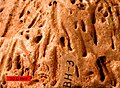
Excavation tubes in the Beacon Supergroup
Informal example of Skolithos excavation tubes

The trace fossils are initially dominated by cylindrical and always unbranched Skolithos residential tubes with a diameter of mostly 2 to 4 millimeters, which run perpendicular to the stratification and were probably created by suspension-eating worms . With further development, vertical and horizontal excavation traces were added, as well as traces of movement of larger arthropods .
Informal example of Diplichnite traces

Informal example of Cruziana , produced by trilobites

Informal example of a Rusophycus trilobite rest trail


- Fodinichnia: The feeding marks probably come from marine polystyrene , which were sediment eater . They form either narrow, winding, near-surface forms on flat deposit surfaces or longer, larger forms with a diameter of 13 centimeters and a length of 1 meter. There is also evidence of rhythmic excretions.
- Beaconites antarcticus: Produced narrow, parallel grooves about 2.5 centimeters apart, which disappear in elliptical pits. They are created by pushing the bottom sediment away before digging into the sediment.
- Wider, protruding tracks of about 3 centimeters with small footprints indicate many limbs with an approximately rectangular shape. They could come from trilobites or from other arthropods .
- Large tracks up to about 30 cm wide with a dragging track from a central tail. The footprints have spikes on their hind legs. Possible Spurenbildner could sea scorpions or horseshoe crabs come into question.
- Double-rowed diplichnite traces, which were previously attributed to trilobites, but could also be due to annelids or millipedes .
- Cruziana and Rusophycus are ribbon-like bilaterally symmetrical locomotion or combined locomotion and feeding tracks that were created either directly on or just below the sediment surface. In Rusophycus there are also traces of rest. It was probably caused by trilobites or other arthropods.
Web links
- Arthur B. Ford : Antarctica. In: Encyclopædia Britannica, inc., March 13, 2019. Online article
- Geology of Antarctica. PDF
- Margaret A. Bradshaw: The Taylor Group (Beacon Supergroup): the Devonian sediments of Antarctica. In: Geological Society, London, Special Publications, 381, 67-97, 6 August 2013. doi: 10.1144 / SP381.23 , alternative
Individual evidence
- ^ Georg Kleinschmidt: Geological development and tectonic structure of the Antarctic. In: Warning signal climate: The polar regions. Scientific evaluations, Hamburg. 376 pages. ISBN 978-3-9809668-6-3 . PDF
- ^ Duncan Stewart, Jr .: The Petrography of the Beacon Sandstone of South Victoria Land. In: Part of a dissertation submitted in partial fulfillment of the requirements for the degree of Doctor of Philosophy, in the University of Michigan. PDF
- ^ PJ Barrett, David H. Elliot and John F. Lindsay: The Beacon Supergroup (Devonian ‐ Triassic) and Ferrar Group (Jurrasic) in the Beardmore Glacier Area, Antarctica. In: Geological Society, London, Special Publications, 10.1144 / SP463.1, 463, 1, (41-58), (2017). doi: 10.1029 / AR036p0339 , alternatively
- ^ MA Bradshaw and FJ Harmsen: The paleoenvironmental significance of trace fossils in Devonian sediments (Taylor Group), Darwin Mountains to the Dry Valleys, southern Victoria. In: US Geological Survey and The National Academies; USGS OF-2007-1047, Extended Abstract 133. PDF