Braak
| coat of arms | Germany map | |
|---|---|---|

|
Coordinates: 53 ° 37 ' N , 10 ° 15' E |
|
| Basic data | ||
| State : | Schleswig-Holstein | |
| Circle : | Stormarn | |
| Office : | Siek | |
| Height : | 58 m above sea level NHN | |
| Area : | 7.51 km 2 | |
| Residents: | 967 (Dec. 31, 2019) | |
| Population density : | 129 inhabitants per km 2 | |
| Postal code : | 22145 | |
| Area code : | 040 | |
| License plate : | OD | |
| Community key : | 01 0 62 011 | |
| LOCODE : | DE KKK | |
| Office administration address: | Hauptstrasse 49 22962 Siek |
|
| Website : | ||
| Mayor : | Hans-Ulrich Schmitz ( CDU ) | |
| Location of the municipality of Braak in the Stormarn district | ||
Braak is a municipality in the Stormarn district in Schleswig-Holstein .
geography
Braak was created as a forest clearing village in the form of a Rundangerdorf in the former Slavic-Saxon border area with originally seven hooves . The Braaker Au rises on the northern edge of the village .
history
Braak was first mentioned in a document in 1256, but it was probably founded around 1245. It was created as part of the Saxon colonization in the east on the border with the Slavic settlement areas.
In 1310 the Holstein counts Gerhard II and Adolf VI sold. the village to the Cistercian nuns - monastery in Reinbek . In the course of the Reformation and the associated dissolution of the monastery, Braak came into the possession of King Frederick I of Denmark , who incorporated it into the old sovereign office of Reinbek . In 1814 the Danes were defeated here in a battle with the Russians.
After the annexation of Schleswig-Holstein by Prussia , Braak finally came to the district of Alt-Rahlstedt in 1889 . As Alt-Rahlstedt 1927, the newly formed large village Rahlstedt slammed, Braak came to the District Siek, from which after the Second World War, today's office Siek emerged.
Braaker base
In the area of the municipality of Braak, the Altona astronomer Heinrich Christian Schumacher measured the so-called “Braaker Basis”, a completely straight line of 5875.219 m, with extreme accuracy around 1820. This baseline was the basis for Schumacher's Danish degree measurement and the Hanoverian national measurement by Carl Friedrich Gauß .
politics
Community representation
Of the eleven seats in the municipal council has CDU since the local elections in 2013 five seats, the voter community BBV has four and the voter community ADB two seats.
coat of arms
Blazon : "In green, a raised silver tip, in it seven gable-end red farmhouses arranged around a red lily."
Culture and sights
The list of cultural monuments in Braak includes the cultural monuments entered in the list of monuments of Schleswig-Holstein.
In Braak there is a volunteer fire brigade with a music train and a Braak senior culture group.
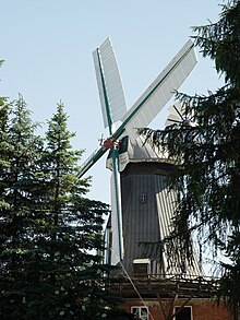
The Braaker Mühle association operates the windmill located south of Braaks center , the flour of which is processed by the large bakery of the same name. The mill was built in 1850 and has been owned by the Lessau millers and bakers since 1859. In 1977 the operation was temporarily stopped, in 1983 the building was listed and extensively renovated.
Economy and Infrastructure
Companies
For a long time the traditional bakery Braaker Mühle was the largest employer in town.
When the Stapelfeld / Braak industrial estate was expanded in 2013, the owner-managed wholesaler BOLTZE Group relocated its headquarters to Braak and has since been the largest employer in the area with almost 300 employees.
education
The mobile library in the Stormarn district stops at two stops in Braak every 3 weeks.
traffic
The community is located on the federal motorway 1 in the catchment area of Hamburg .
literature
- Matthäus Berg: Chronicle of Braak. From the history and culture of a Stormarn village. Braak 1979
Web links
Individual evidence
- ↑ North Statistics Office - Population of the municipalities in Schleswig-Holstein 4th quarter 2019 (XLSX file) (update based on the 2011 census) ( help on this ).
- ↑ Gerd Hoffmann, Karl-Heinz Nerkamp: Heinrich Christian Schumacher - The Altona astronomer and measurement. Hamburg State Office for Geoinformation and Surveying 2009 hamburg.de pdf
- ↑ Schleswig-Holstein's municipal coat of arms
- ^ History. June 8, 2017. Retrieved April 11, 2019 .
- ↑ 2017 timetable of the mobile library , website of the Schleswig-Holstein library center, accessed on June 5, 2017


