
Cața
|
Cața Katzendorf Kaca |
|||||
|
|||||
| Basic data | |||||
|---|---|---|---|---|---|
| State : |
|
||||
| Historical region : | Transylvania | ||||
| Circle : | Brașov | ||||
| Coordinates : | 46 ° 5 ' N , 25 ° 17' E | ||||
| Time zone : | EET ( UTC +2) | ||||
| Height : | 467 m | ||||
| Area : | 118.12 km² | ||||
| Residents : | 2,463 (October 20, 2011) | ||||
| Population density : | 21 inhabitants per km² | ||||
| Postal code : | 507040 | ||||
| Telephone code : | (+40) 02 68 | ||||
| License plate : | BV | ||||
| Structure and administration (as of 2016) | |||||
| Community type : | local community | ||||
| Structure : | Cața, Beia , Drăuşeni , Ioneşti , Paloş | ||||
| Mayor : | Gheorghe Vocilă ( PNL ) | ||||
| Postal address : | Str. Principală, no. 223 Cața, jud. Brașov, RO-507040 |
||||
| Website : | |||||


Cața ( German Katzendorf , Hungarian Kaca ) is a municipality in the Brașov district in Transylvania , Romania .
Geographical location

The municipality of Cața is located in the east of the Transylvanian Basin , in the north of the Brașov district. In the Homoroder Depression, at the confluence of the Paloș with the Great Homorod, a source river of the Homorod , on the national road ( Drum național ) DN 132B and the railway line Teiuș – Brașov , the place is about 8 kilometers north of Rupea ( Reps ); the district capital Brașov ( Kronstadt ) is located about 70 kilometers southeast of Cața.
history
The history of settlement in the region goes back to the Neolithic . In the area of the municipality - on an area called "The Stone Mountain" ( Dealu Pietrei ) by the locals and in a nearby cave - according to G. Téglás , P. Pósta , I. Martian , M. Roska , G. Téglás and K. Horedt made numerous finds that point to dwellings from the Neolithic and Roman times .
Katzendorf was probably founded by Transylvanian Saxons in the 12th or 13th century . The first documentary mention comes from the time around 1400, when in a register of the interest payments for the church, the settlement Katzendorf is listed under the villages of the chapter Reps .
In 1515 an attempt by General Giovanni Battista Castaldo to lend the place to nobles failed . In 1540 the farmers of Cața bought the land in the village from the Hungarian nobleman Ferenc (Francis) Katzai de Galambfalva for 80 guilders. Turks and Tatars invaded the place in 1658 and burned it down. Katzendorf was ravaged by fires in 1683, 1706 and 1749. In 1706 the entire village and the church burned down.
The place is also known because of its typical, rich carpentry painting and, since some families had up to seven horses, also known as the "horse village". The main occupations of the population today are agriculture and livestock.
population
The population of the municipality developed as follows:
| census | Ethnic composition | |||||||
|---|---|---|---|---|---|---|---|---|
| year | population | Romanians | Hungary | German | other | |||
| 1850 | 4,523 | 2.002 | 323 | 1,815 | 383 | |||
| 1920 | 4,709 | 2,287 | 574 | 1,825 | 23 | |||
| 1941 | 4.263 | 1,471 | 696 | 1,721 | 375 | |||
| 1977 | 3,359 | 1,360 | 939 | 531 | 529 | |||
| 1992 | 2,491 | 1,034 | 808 | 41 | 608 | |||
| 2002 | 2,570 | 1,079 | 888 | 20th | 583 | |||
| 2011 | 2,463 | 1,088 | 751 | 16 | 608 | |||
Since the official survey of 1850, the highest number of inhabitants - and at the same time that of Romanians and Romanian Germans - was determined in the area of today's municipality in 1920. The highest number of Hungarians (1,190) was registered in 1966 and that of Roma in 1992. Furthermore, one Ukrainian was registered in 1977, two Ukrainians in 2002 , 34 in 1910 and one in 1966 as Serbs, and ten Slovaks in the 1880 census .
Until the end of the Second World War, Romanians and Saxons lived almost equally on the territory of the municipality , with Draas , Katzendorf and Meeburg having a German majority , Paloş a Romanian and Ioneşti a Hungarian majority. With the withdrawal of the German troops in early September 1944, German officers ordered the evacuation of the Saxons from Katzendorf and Draas ( Drăușeni ). After a seven-week trip on the trek , accompanied by 3-4 German soldiers, it arrived in Amstetten ( Lower Austria ). In April 1945, most of the refugees in the area around Amstetten were returned to Romania by the Red Army .
Attractions
- The fortified church, built in the 13th century, has been rebuilt, expanded and renovated several times in its history. The three-aisled Romanesque pillar basilica with two Romanesque twin windows was built in 1250. Surrounded by the two 4 meter high walls of the fortification, there are three towers on the inner ring; on the outer - partly disintegrated - the pentagonal "pastor's tower" has stood since 1676. The last renovation work took place in 1969/70. In 2010, the roof of the fortified church will be renovated by the Hermann Niermann Foundation . The fortified church and basilica are under monument protection.
- The center of the village ( Piața Centrală built in the 13th century and rebuilt in the 19th), the houses of Michael Lienert (No. 59, built in 1808), Günther Thomes (No. 266, built in 1833), Hones-Marcus (No. 142, erected in 1824) and by Georg Mathie (no. 265, erected 1872–1883) are listed buildings.
- The Protestant rectory, built in the 18th century, was restored and expanded by the writer Frieder Schuller . Schuller has been organizing national and international cultural meetings here since 1992, with the "Katzendorf Village Writer Prize" being awarded. The rectory is a listed building.
- The former German school (built in 1884, today the village school) and the former Romanian school (built in 1936) are listed as historical monuments.
- The Romanian Orthodox Church Sf. Treime , built in the 18th century, is a listed building.
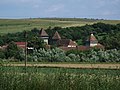
The fortified church
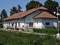
The station
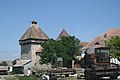
The fortified church

Cattle fire sign of the place
_-_Kirchenburg.jpg)


Personalities
- Ioan Popescu (1832–1892), educator and member of the Romanian Academy .
- Frieder Schuller (* 1942), writer and film director
Web links
Individual evidence
- ↑ 2011 census in Romania ( MS Excel ; 1.3 MB)
- ^ Institute Of Archeology - Cața, accessed November 26, 2010 (Romanian)
- ↑ Rupea-cohalm.ro, Caţa - The Protestant Fortified Church (PDF; 136 kB) accessed on January 1, 2010 ( memento of the original from November 9, 2013 in the Internet Archive ) Info: The archive link was inserted automatically and has not yet been checked. Please check the original and archive link according to the instructions and then remove this notice.
- ↑ Erwin Amlacher: Defense structure function and systematics of Transylvanian-Saxon church and farm castles. A contribution to European castle studies (= publications of the Institute for German Culture and History of Southeast Europe (IKGS). Scientific series, vol. 95). IKGS-Verlag, Munich 2002, ISBN 3-88356-159-2 , p. 127.
- ↑ a b Heinz Heltmann, Gustav Servatius (Ed.): Travel Guide Siebenbürgen. Kraft, Würzburg 1993, ISBN 3-8083-2019-2 .
- ↑ Census, last updated November 1, 2008, p. 18 (Hungarian; PDF; 525 kB)
- ^ Evacuation of the communities of Katzendorf and Draas by advancing German troops in "The fate of the Germans in Romania", accessed on November 27, 2010 ( Memento of March 14, 2010 in the Internet Archive )
- ^ Siebenbuerger.de - Hermann-Niermann-Stiftung secures fortified churches, accessed on January 1, 2010
- ↑ a b c d e List of historical monuments of the Romanian Ministry of Culture, updated 2010 (PDF; 7.10 MB)
- ↑ Elise Wilk: I live in two worlds , interview with Frieder Schuller on September 24, 2014 from adz.ro, accessed on March 22, 2016
- ↑ Ioan Popescu, on the website of the Romanian Academy, accessed on November 26, 2010 (Romanian)
- ↑ Frieder Schuller at litde.com
Apața | Augustine | Beclean | Bod | Bran | Budila | Buneşti | Cața | Cincu | Comăna | Cristian | Crizbav | Drăguș | Dumbrăvița | Feldioara | Fundata | Hălchiu | Hărman | Hârseni | Hoghiz | Holbav | Homorod | Jibert | Lisa | Măieruș | Mândra | Moieciu | Ormeniș | Părău | Poiana Mărului | Prejmer | Racoș | Recea | Sâmbăta de Sus | Sânpetru | Șercaia | Șinca | Șinca Nouă | Șoarș | Tărlungeni | Teliu | Ticușu | Ucea | Ungra | Vama Buzăului | Viștea | Voila | Vulcan