Chêne-en-Semine
| Chêne-en-Semine | ||
|---|---|---|
|
|
||
| region | Auvergne-Rhône-Alpes | |
| Department | Haute-Savoie | |
| Arrondissement | Saint-Julien-en-Genevois | |
| Canton | Saint-Julien-en-Genevois | |
| Community association | Usses and Rhône | |
| Coordinates | 46 ° 3 ' N , 5 ° 52' E | |
| height | 320-553 m | |
| surface | 9.46 km 2 | |
| Residents | 496 (January 1, 2017) | |
| Population density | 52 inhabitants / km 2 | |
| Post Code | 74270 | |
| INSEE code | 74068 | |
| Website | www.chene-en-semine.fr | |
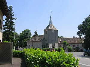
 The center of Chêne-en-Semine with the village church |
||
Chêne-en-Semine is a French commune in the department of Haute-Savoie in the region of Auvergne Rhône-Alpes .
geography
Chêne-en-Semine is at 510 m , near Bellegarde-sur-Valserine , about 26 kilometers northwest of the city of Annecy (as the crow flies). The farming village extends on the edge of a high plateau that extends between the Rhone valley east of the Jura and the Montagne de Vuache , in the Genevois .
The area of the 9.46 km² large municipality covers a section of the western Genevois. The central part of the area is occupied by the high plateau, which is predominantly forested ( Bois du Clos ). Here, at 553 m, the highest point in Chêne-en-Semine is reached. Towards the west, the plateau gradually emerges from the Rhône valley. In the southeast, the community area extends into the valley system of the Ruisseau de Marsin , a right side stream of the Usses .
In addition to the actual town center, Chêne-en-Semine also includes several hamlet settlements and farms, including:
- Fœnens ( 490 m ) in a side valley of the Rhône
- Arjon ( 500 m ) on a ledge above the valley of the Ruisseau de Marsin
- Essertoux ( 420 m ) on the western slope of the Ruisseau de Marsin
- Girod ( 440 m ) on a ledge on the western slope of the Ruisseau de Marsin
Neighboring municipalities of Chêne-en-Semine are Saint-Germain-sur-Rhône , Éloise and Clarafond-Arcine in the north, Vanzy in the east, Usinens and Challonges in the south and Franclens in the west.
history
Chêne-en-Semine was the center of a parish as early as the 12th century.
Attractions
The village church of Chêne-en-Semine was given its current appearance when it was rebuilt in the 17th century. Parts of the former priory have been preserved.
Population development
| year | Residents |
|---|---|
| 1962 | 197 |
| 1968 | 204 |
| 1975 | 183 |
| 1982 | 198 |
| 1990 | 234 |
| 1999 | 257 |
| 2006 | 349 |
With 496 inhabitants (as of January 1, 2017), Chêne-en-Semine is one of the small communities in the Haute-Savoie department. In the course of the 19th and 20th centuries, the number of inhabitants decreased continuously due to strong emigration (in 1861 there were still 385 inhabitants in Chêne-en-Semine). However, the population has increased again since the early 1980s.
Economy and Infrastructure
Chêne-en-Semine is still a predominantly agricultural village today . There are also some local small businesses. A large number of those in employment are commuters who work in the larger towns in the area, particularly in Bellegarde-sur-Valserine .
The village is very well developed in terms of traffic. It is located near the departmental road that leads from Frangy to Génissiat . There are other road connections with Saint-Germain-sur-Rhône and Vanzy. The closest connection to the A40 motorway is around 3 km away.
Web links
- official website of the municipality (French)
Individual evidence
- ↑ Chêne-en-Semine - notice communale. In: cassini.ehess.fr. Retrieved April 26, 2014 (French).
