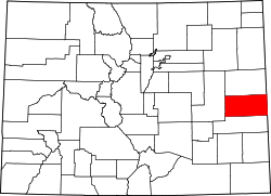
Cheyenne County, Colorado
 Cheyenne County Courthouse |
|
| administration | |
|---|---|
| US state : | Colorado |
| Administrative headquarters : | Cheyenne Wells |
| Foundation : | March 25, 1889 |
| Demographics | |
| Residents : | 1836 (2010) |
| Population density : | 0.4 inhabitants / km 2 |
| geography | |
| Total area : | 4614 km² |
| Water surface : | 0 km² |
| map | |
Cheyenne County [ ʃaɪˈɛn ] is an administrative unit ( county ) in the eastern part of the US state Colorado . The county seat is Cheyenne Wells .
geography
The county is enclosed by the counties Kit Carson in the north, Lincoln in the west and Kiowa in the south, while in the east the state border runs with Kansas and there the districts of Wallace and Greeley connect.
Cheyenne is extremely sparsely populated. Just about 2000 people live in an area roughly the size of the Ruhr area .
Demographic data
| growth of population | |||
|---|---|---|---|
| Census | Residents | ± in% | |
| 1890 | 534 | - | |
| 1900 | 501 | -6.2% | |
| 1910 | 3687 | 635.9% | |
| 1920 | 3746 | 1.6% | |
| 1930 | 3723 | -0.6% | |
| 1940 | 2964 | -20.4% | |
| 1950 | 3453 | 16.5% | |
| 1960 | 2789 | -19.2% | |
| 1970 | 2396 | -14.1% | |
| 1980 | 2153 | -10.1% | |
| 1990 | 2397 | 11.3% | |
| 2000 | 2231 | -6.9% | |
| 2010 | 1836 | -17.7% | |
| Before 1900
1900–1990 2000 2010 |
|||
As of the 2000 census , the county had 2,231 people. There were 880 households and 602 families. The population density was 0.3 inhabitants per square kilometer. The racial the population was composed of 92.87 percent white, 0.49 percent African American, 0.76 percent Native American, 0.13 percent Asian, 0.00 percent of residents from the Pacific island area and 5.11 percent from other ethnic groups Groups; 0.63 percent were descended from two or more races. Hispanic or Latino of any race was 8.11 percent of the population.
Of the 880 households, 34.1 percent had children and adolescents under the age of 18 living with them. 59.3 percent were married couples living together, 5.7 percent were single mothers. 31.5 percent were not families. 29.0 percent were single households and 12.4 percent had people aged 65 or over. The average household size was 2.50 and the average family size was 3.12.
For the entire county, the population was composed of 28.8 percent of residents under the age of 18, 7.1 percent between 18 and 24 years of age, 26.2 percent between 25 and 44 years of age, and 21.3 percent between 45 and 64 years of age 16.6 percent were 65 years of age or over. The median age was 38 years. For every 100 females there were 100.6 males, and for every 100 females aged 18 and over there were 98.4 males.
The median income for a household in the 37,054 USD , and the median income for a family was 44,394 USD. Males had a median income of $ 32,250 versus $ 19,286 for females. The per capita income was $ 17,850. 11.1 percent of the population and 8.7 percent of families are below the poverty line. These included 12.9 percent of the population under the age of 18 and 10.9 percent of the population aged 65 and over.
Others
Cheyenne County hit the media in October 2013 when it became known that a majority of the population was in favor of a split from Colorado and the formation of a 51st state due to the rejection of stricter gun laws.
places
Individual evidence
- ↑ GNIS-ID: 198124. Retrieved on February 22, 2011 (English).
- ↑ US Census Bureau - Census of Population and Housing . Retrieved March 15, 2011
- ↑ Extract from Census.gov . Retrieved February 28, 2011
- ↑ Excerpt from factfinder.census.gov.Retrieved February 28, 2011
- ^ Extract from census.gov.Retrieved March 31, 2012
Web links
Coordinates: 38 ° 49 ′ N , 102 ° 35 ′ W

