
Fleury (Aude)
| Fleury | ||
|---|---|---|
.svg)
|
|
|
| region | Occitania | |
| Department | Aude | |
| Arrondissement | Narbonne | |
| Canton | Les Basses Plaines de l'Aude | |
| Community association | Le Grand Narbonne | |
| Coordinates | 43 ° 14 ' N , 3 ° 8' E | |
| height | 0-163 m | |
| surface | 51.27 km 2 | |
| Residents | 3,825 (January 1, 2017) | |
| Population density | 75 inhabitants / km 2 | |
| Post Code | 11560 | |
| INSEE code | 11145 | |

Fleury is a French commune with 3825 inhabitants (as of January 1, 2017) in the Aude department in the Occitanie region ; it belongs to the arrondissement of Narbonne and the canton of Les Basses Plaines de l'Aude .
Fleury, which used to be called Pérignan, is about 12 kilometers from Narbonne and 15 kilometers from Béziers . It is the easternmost municipality in the Aude department. The municipality consists of the three settlements Fleury-d'Aude, the historical place in the hinterland, the seaside resort of Saint-Pierre-la-Mer , the fishing village of Les Cabanes de Fleury at the mouth of the Aude and some hamlets and individual farms. The municipality to the east of the A9 autoroute is part of the Narbonnaise en Méditerranée Regional Nature Park .
Population development
- 1962: 2014
- 1968: 2030
- 1975: 1877
- 1982: 2027
- 1990: 2264
- 1999: 2547
- 2006: 3146
- 2017: 3825
Attractions
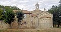
- Romanesque church of Saint-Martin
- Notre-Dame de Liesse chapel (17th century)
- Étang de Pissevache
- Gouffre de l'Œil Doux, a cenote in the Massif de la Clape
- Beaches of Saint-Pierre-sur-Mer and Les Cabanes de Fleury

The Saint-Martin church
The Notre-Dame de Liesse chapel, south-east side
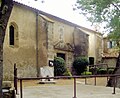
The Notre-Dame de Liesse chapel, southwest side

The Gouffre de l'Œil Doux


Personalities
- Jean Hercule de Rosset de Rocozels de Fleury (1683–1748), Baron de Pérignan (1714), Marquis de Rocozels (1724), Duc de Fleury, Pair de France (1736).