Canet (Aude)
| Canet | ||
|---|---|---|

|
|
|
| region | Occitania | |
| Department | Aude | |
| Arrondissement | Narbonne | |
| Canton | Le Sud-Minervois | |
| Community association | Région Lézignanaise, Corbières et Minervois | |
| Coordinates | 43 ° 14 ' N , 2 ° 51' E | |
| height | 18-37 m | |
| surface | 14.04 km 2 | |
| Residents | 1,778 (January 1, 2017) | |
| Population density | 127 inhabitants / km 2 | |
| Post Code | 11200 | |
| INSEE code | 11067 | |
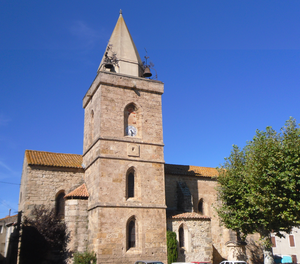
 Saint Martin Church |
||
Canet ( Occitan : identical) is a place and a municipality with 1,778 inhabitants (as of January 1, 2017) in the south of France in the Aude department in the Occitania region .
location
The place Canet is about one kilometer south of the river Aude in the east of the Corbières mountains at an altitude of about 25 m . The next larger city, Narbonne , is about 16 kilometers (driving distance) to the southeast.
history
The bishops of Narbonne were landlords ( seigneurs ) of Canodo from the early Middle Ages (782) until the French Revolution . From the beginning of the 12th century, the Counts of Carcassonne also owned land in Canet.
Population development
| year | 1968 | 1975 | 1982 | 1990 | 1999 | 2007 | 2017 |
| Residents | 1,030 | 910 | 837 | 939 | 1072 | 1203 | 1778 |
In the 19th century the number of inhabitants rose from around 500 to over 1,400 people. The phylloxera crisis in viticulture and the mechanization of agriculture have led to a continuous decline in population since then. The proximity to the city of Narbonne has led to an increase in the number of residents again in recent decades.
economy
A large part of the agricultural land is reserved for viticulture . Some of the hilly vineyards are within the protected designation of origin Corbières (AOC) ; others are marketed through the Aude , Languedoc , Pays Cathare and Pays d'Oc appellations. Some vacant houses have been converted into holiday apartments ( gîtes ).
Attractions
- Only sparse remains of the medieval castle ( château ) have remained after the destruction during and after the French Revolution.
- The parish church of Saint-Martin makes a rural Gothic impression and is likely from the 13th / 14th centuries. Century. The bell tower , built in Romanesque style, is a work of the 19th century.
- The Notre-Dame des Vignes chapel dates from 1858 and was originally the burial place of the wealthy Roussignol-Jaloux family ; after the expansion of the local cemetery, their bones were moved there.
- Surroundings
- A mill belonging to the Bishop of Narbonne is mentioned as early as 1237; the square defense tower could still come from this time. Later the upper floor of the tower was converted into a pigeon house ( pigeonnier ). The current building, lying in ruins, can be dated mainly to the 18th century; it has been recognized as a monument historique since 1948 .
Web links
- Canet, wine - photos + info (French)
- Canet, history - photos + information (French)
- Canet, sights - photos + information (French)
Individual evidence
- ^ Moulin fortifiée, Canet in the Base Mérimée of the French Ministry of Culture (French)
