
Furlbachtal
|
Gorges and moors on the upper Furlbach
|
||
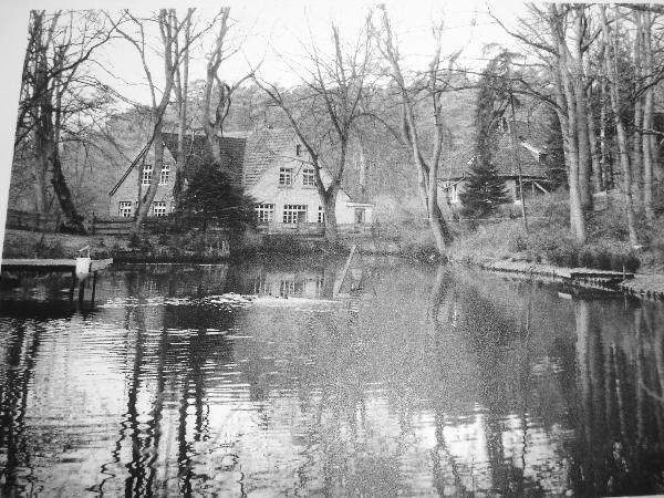
 Furlbach in the Furlbachtal |
||
| location | North Rhine-Westphalia , Germany | |
| surface | 205 ha | |
| Geographical location | 51 ° 53 ' N , 8 ° 42' E | |
|
||
| Setup date | 1937 | |
| administration |
Lower landscape authority of the Gütersloh district Lower landscape authority of the Lippe district |
|

The Furlbachtal is a 205 hectare nature reserve in the Senne in North Rhine-Westphalia (official name: "Schluchten und Moore am Ober Furlbach"). 121 hectares are in the municipality of Schloß Holte-Stukenbrock in the Gütersloh district , 84 hectares belong to Augustdorf in the Lippe district .
Furlbach
The 14.6 km long Furlbach flows through the valley . It is a right tributary of the Ems , which rises near Augustdorf in the upper Senne and flows into the Ems south of Kaunitz . The Furlbach drains an area with an area of 48.6 km². There is not a single source of the Furlbach, its headwaters lie in a large arch of dunes, whereby the water emerges in many places.
Flora and fauna
The nature reserve (listed with the numbers GT-002 and LIP-018) is almost completely forested. While oaks , beeches , birches and alders grow on the Furlbach , the vegetation on the inland dunes is characterized by pines . Rarer plant species that grow in the Furlbachtal are z. B. sundew , rosemary heather , cranberries and cotton grass in the moors , bog berries , king fern , club moss and small wintergreen in the mixed pine forests or seven star and giant horsetail at the Furlbach springs.
The primeval forest-like condition of the area offers ideal living conditions for bird species such as black and great spotted woodpecker , dipper , kingfisher , stock dove , woodcock and gray wagtail . Because of the good water quality , the Furlbach is an important breeding ground for the endangered fish species bullhead and brook lamprey. Brown trout can be found here as well as green frogs and common toads . In the moors, two highly endangered dragonfly species, the peat mosaic maiden and the little moss maiden, find good living conditions.
history
.jpg)
For the production of roof tiles , peat used to be dug up in Furlbachtal in order to be able to break down the accumulating clay layer. After the end of the mining, rainwater ran into the clay basins - this is where the so-called bent ponds were created, which are now a valuable biotope.
The flow rate of the Furlbach in the upper reaches is so great that a watermill, the Tütgemühle, was built there in 1849. It was operated until 1925, used as a country school home from 1951 and demolished in 1978.
As early as 1937, 17.5 hectares in the Furlbachtal (then located in the Paderborn district) were registered as a nature reserve. On March 11, 1991, the Senne landscape plan expanded the protected area to its present size. The area has been part of the Europe-wide Natura 2000 network since 2004 .
use
The Furlbachtal serves as a local recreation area for the cities of Bielefeld and Paderborn. There are two circular hiking trails. The Senne Nature Conservation Center of the Paderborn-Senne District Biological Station , which is responsible for maintaining the Furlbachtal, offers guided tours along a natural history trail .
The amount of precipitation in the region is relatively high at up to 900 mm per year. The Stadtwerke Bielefeld win in Furlbachtal since 1979 from nine wells (one deep well, promotes the water from more than 400 m depth, and eight shallow wells) around one million cubic meters of drinking water per year. A pumping station pumps the drinking water to Bielefeld via long-distance water pipes.
Individual evidence
Web links
- Nikolaus Risch and the Furlbachtal
- Furlbachtal hiking guide. Nature and groundwater protection go hand in hand
- Photo of the Tütgemühle
- Nature reserve "Furlbachtal" (GT-002) in the specialist information system of the State Office for Nature, Environment and Consumer Protection in North Rhine-Westphalia
- Nature reserve “Furlbachtal” (LIP-018) in the specialist information system of the State Office for Nature, Environment and Consumer Protection in North Rhine-Westphalia
- World Database on Protected Areas - NSG gorges and moors on the upper Furlbach, Gütersloh district (English)
- World Database on Protected Areas - NSG gorges and moors on the upper Furlbach, Lippe district (English)

Am Lichtebach | At Merschgraben | At Sundern | Greffener Mark quarry pond | Barrel pillar | Boom Mountains | Harrow | Emssee | Erlenbruch and Schlosswiesen Rheda | Wet meadow Vennheide | Feuchtwiesen Hörste | Wet meadows in the desert | Moist meadows Ströhen | Fleckernheide | Foddenbach-Landbach | Furlbachtal | Gartnischberg | Sea meadows | Gray heron colony near Harsewinkel | Big meadow | Big Mountain - Hellberg | Hesselner Mountains | Holter Forest | Chicken Moor | In the Binner | Jakobsberg | Johannisegge chimney | Kipshagen Ponds | Knüll - Storkenberg | Kraalbusch | Mersch | Moosheide | Ölbachtal with Augustdorfer Dünenfeld | Ravensberg - Barenberg | Rietberger Emsniederung | Rietberger fish ponds | Salt pond heather | Schellenwiese | Spexard | Schneiker quarry | Tatenhauser Forest | Versmolder Bruch | Wehrbachtal