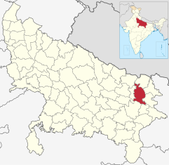
Gorakhpur (District)
| Gorakhpur District गोरखपुर जिला |
|
|---|---|

|
|
| State | Uttar Pradesh |
| Division : | Gorakhpur |
| Administrative headquarters : | Gorakhpur |
| Area : | 3321 km² |
| Residents : | 4,440,895 (2011) |
| Population density : | 1,337 inhabitants / km² |
| Website : | gorakhpur.nic.in |
The Gorakhpur District ( Hindi : गोरखपुर जिला ) is a district in the Indian state of Uttar Pradesh . The administrative center is the eponymous city of Gorakhpur .
geography
The Gorakhpur district is located in northeast Uttar Pradesh. Neighboring districts are Maharajganj in the north, Kushinagar in the northeast, Deoria in the east, Mau in the southeast, Azamgarh in the south, Ambedkar Nagar in the southwest and Sant Kabir Nagar in the west.
The district area covers an area of 3321 km² and belongs entirely to the flat Ganges plain . In the south, the Gorakhpur district is bounded by the Ghaghara , a large tributary of the Ganges . In addition, the Rapti and Rohini rivers flow through the district area.
Administrative division
The Gorakhpur District is part of the Gorakhpur Division . It is divided into the seven Tehsils Sadar, Chauri Chaura, Sahjanwa, Khajni, Campierganj, Bansgaon and Gola.
history
The Gorakhpur district has existed since British colonial times . It came into being after the Nawab of Oudh ceded the Gorakhpur area to the British. Originally, the district comprised a much larger area, which gradually became smaller through the establishment of new districts: In 1865, the western part of the Gorakhpur district was formed into the Basti district (this also included the area of today's Siddhartnagar and Sant Kabir Nagar districts at the time ). In 1946 the eastern part split off as the Deoria district (including today 's Kushinagar district ). Finally, in 1989, the Maharajganj district was formed from the northern part of Gorakhpur .
population
According to the 2011 Indian census, the Gorakhpur district has 4,440,895 inhabitants. In terms of population, it is one of the larger districts of Uttar Pradesh. Between 2001 and 2011, the population grew by 18 percent and somewhat more slowly than the Uttar Pradesh mean (20 percent). The population density of 1337 inhabitants per km² is well above the already high average of the state (829 inhabitants per km²). With Gorakhpur, the district is home to the twelfth largest city in Uttar Pradesh. At 19 percent, the degree of urbanization is below the Uttar Pradesh mean (22 percent). At 71 percent, the literacy rate is higher than the Uttar Pradesh mean (68 percent), but slightly lower than the overall Indian average (73 percent).
According to the 2001 census , Hindus make up a clear majority of the district's residents with 90 percent. There is also a Muslim minority of nine percent.
Cities
| city | Population (2001) |
|---|---|
| Air Force Area | 9,593 |
| Bansgaon | 14,086 |
| Barhalganj | 19,171 |
| Gola Bazaar | 10,613 |
| Gorakhpur | 624,570 |
| Mundera Bazaar | 11,226 |
| Pipiganj | 11,386 |
| Pipraich | 14,829 |
| Sahjanwa | 25.091 |
literature
- The Imperial Gazetteer of India. Volume 12: Einme to Gwalior. New edition. Clarendon Press, Oxford 1908, pp. 331–341 , keyword: Gorakhpur District .
Web links
Individual evidence
- ↑ Census of India 2011: Primary Census Abstract - Uttar Pradesh (PDF; 1.7 MB).
- ^ Census of India 2001: Basic Data Sheet. District Gorakhpur (58), Uttar Pradesh (09). (PDF; 55 kB)
- ↑ Census of India 2001: Population, population in the age group 0-6 and literates by sex - Cities / Towns (in alphabetic order) ( Memento from June 16, 2004 in the Internet Archive )
