
Hărman
|
Hărman Honigberg Szászhermány |
|||||
|
|||||
| Basic data | |||||
|---|---|---|---|---|---|
| State : |
|
||||
| Historical region : | Transylvania | ||||
| Circle : | Brașov | ||||
| Coordinates : | 45 ° 42 ' N , 25 ° 41' E | ||||
| Time zone : | EET ( UTC +2) | ||||
| Height : | 529 m | ||||
| Area : | 52.79 km² | ||||
| Residents : | 5,402 (October 20, 2011) | ||||
| Population density : | 102 inhabitants per km² | ||||
| Postal code : | 507085 | ||||
| Telephone code : | (+40) 02 68 | ||||
| License plate : | BV | ||||
| Structure and administration (as of 2016) | |||||
| Community type : | local community | ||||
| Structure : | Hărman, Podu Oltului | ||||
| Mayor : | Mihai Dișor ( PNL ) | ||||
| Postal address : | St. Mihai Viteazul, no. 1 loc. Hărman, jud. Brașov, RO-507085 |
||||
| Website : | |||||


Hărman ( German honey mountain , såksesch Huntschprich , Hungarian Szaszhermany ) is a municipality in the district of Brasov in Transylvania , Romania .
Geographical location

The municipality of Hărman is located in the historical Burzenland region in the east of the Brașov district . The community center is located on the national road DN 11 , about 12 kilometers northeast of the district capital Brașov (Kronstadt) . Furthermore, Hărman is on the railway lines Brașov – Târgu Secuiesc and Brașov – Întorsura Buzăului .
history


The Hungarian King Andreas II awarded Burzenland to the Teutonic Knight Order in 1211 , who settled here, built castles, brought German settlers into the country and founded villages, including Honigberg. After disputes with the king, the order was expelled from Burzenland in 1225, but the German settlements remained.
The first documentary mention was made in 1240 under Mons Mellis ( mountain of honey ). At that time, King Bela IV gave the Cistercian order patronage over the churches of Marienburg , Petersberg , Honigberg and Tartlau .
In 2009 there were still 111 members of the evangelical community (Transylvanian Saxony).
Demographics
The population development of the municipality of Hărman:
| census | Ethnicity | |||||||
|---|---|---|---|---|---|---|---|---|
| year | Residents | Romanians | Hungary | German | Other | |||
| 1850 | 2,031 | 644 | 12 | 1,252 | 123 | |||
| 1930 | 2,968 | 1,490 | 147 | 1,328 | 3 | |||
| 1977 | 5,778 | 4,414 | 168 | 1,129 | 67 | |||
| 2002 | 4,425 | 3,955 | 113 | 105 | 252 | |||
| 2011 | 5,402 | 4,719 | 123 | 66 | 494 (Roma 247) | |||
Since 1850, the highest number of inhabitants in the area of today's municipality was determined in 1977. The highest population of Romanians was registered in 2011, Romanian Germans (1,359) in 1941, Magyars (169) in 1966 and Roma (249) in 2002. In some of the recordings, one resident each confessed to being a Ukrainian , a Serb or a Slovak .
Attractions
The fortified church , built from around 1280, is impressive and houses an organ by Johannes Prause . It was started according to the Romanesque architecture and completed with many Gothic elements. An interesting peculiarity of the church are the pantries, which nestle like swallow nests under the eaves on the central nave. The eight-storey bell tower - the highest in Burzenland at 52 m - is located in the western part of the central nave and is flanked by the two side aisles.
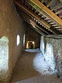
The fortified church is one of the largest fortified churches in Transylvania with an area of 14,526 m² and a circumference of 430 m (without the third wall belt, which is no longer recognizable today). The triple wall belt around the church is roughly circular. The inner ring is 12 m high and 4 m thick at the base. The circular wall is provided with seven four-storey towers, which are connected to 4-5 m high walls at their outer corners and thus form a kennel. The largest of the seven curtain wall towers is the butcher's tower. The eastern tower is the only one with a pent roof and houses a chapel from the 15th century with wall paintings. This representation of the Last Judgment is one of the most valuable painting ensembles from Transylvanian places of worship.
The fortified church could not be taken in 1552 by the Moldovan prince Ștefan Rareş , in 1600 by Mihai Viteazul (Michael the Brave) and in 1612 by Gabriel Bethlen . Not far to the east is Prejmer ( Tartlau ) with a similarly important fortified church.
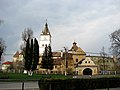
Fortified church in Honigberg

Inner courtyard of the fortified church

Wall painting in the chapel tower
Battlement of the fortified church
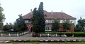
Railway station in Hărman


See also
Web links
- Website of the Evangelical Church Community in Honigberg
- Honigberg on Siebenbürger.de
- Hărman at ghidulprimariilor.ro
Individual evidence
- ↑ 2011 census in Romania ( MS Excel ; 1.3 MB)
- ↑ Dieter Drotleff: Pastors, curators, numbers of souls. In: Allgemeine Deutsche Zeitung. Enclosure: Karpatenrundschau , March 4, 2010, p. 3.
- ↑ E. Varga: Statistics of the population by ethnicity in the Brașov district according to censuses from 1850–2002 (Hungarian; PDF; 512 kB)
- ↑ a b Heinz Heltmann, Gustav Servatius (Ed.): Travel Guide Siebenbürgen. Kraft, Würzburg 1993, ISBN 3-8083-2019-2 .
Apața | Augustine | Beclean | Bod | Bran | Budila | Buneşti | Cața | Cincu | Comăna | Cristian | Crizbav | Drăguș | Dumbrăvița | Feldioara | Fundata | Hălchiu | Hărman | Hârseni | Hoghiz | Holbav | Homorod | Jibert | Lisa | Măieruș | Mândra | Moieciu | Ormeniș | Părău | Poiana Mărului | Prejmer | Racoș | Recea | Sâmbăta de Sus | Sânpetru | Șercaia | Șinca | Șinca Nouă | Șoarș | Tărlungeni | Teliu | Ticușu | Ucea | Ungra | Vama Buzăului | Viștea | Voila | Vulcan