
Dielheim
| coat of arms | Germany map | |
|---|---|---|

|
Coordinates: 49 ° 17 ' N , 8 ° 44' E |
|
| Basic data | ||
| State : | Baden-Württemberg | |
| Administrative region : | Karlsruhe | |
| County : | Rhein-Neckar district | |
| Height : | 138 m above sea level NHN | |
| Area : | 22.67 km 2 | |
| Residents: | 9027 (December 31, 2018) | |
| Population density : | 398 inhabitants per km 2 | |
| Postal code : | 69234 | |
| Area code : | 06222 | |
| License plate : | HD | |
| Community key : | 08 2 26 010 | |
| LOCODE : | DE DHE | |
| Address of the municipal administration: |
Hauptstrasse 37 69234 Dielheim |
|
| Website : | ||
| Mayor : | Thomas glass burner | |
| Location of the community of Dielheim in the Rhein-Neckar district | ||
  |
||

Dielheim is a municipality in the Rhein-Neckar district in Baden-Württemberg .
geography
Geographical location
Dielheim belongs to the Rhine-Neckar metropolitan region and is located on the western edge of the Kraichgau and on the edge of the Upper Rhine Plain . To the south, Dielheim is bounded by the wooded slopes of the Wallenberg, which at 247.8 m above sea level. NN represents the highest elevation on Dielheimer district. The Leimbach flows from east to west through the center of Dielheim and the centers of the districts of Horrenberg and Balzfeld, which rises in Balzfeld. The closest larger cities are Wiesloch (4 km), Heidelberg (20 km) and Sinsheim (15 km).
Community structure
The municipality of Dielheim includes Dielheim (5,888 inhabitants on December 31, 2018) as well as the districts Horrenberg (1,836 inhabitants), Balzfeld (1,027 inhabitants) and the hamlets of Oberhof (30 inhabitants) and Unterhof (291 inhabitants).
The spatial boundaries of the district of Dielheim are identical to the former municipality of Dielheim, the remaining districts are in the area of the former municipality of Horrenberg. Since the phony suburbs were abolished, the former residential districts have been abolished.
Hildebrandeshusen, which was only mentioned in 860, is located in the municipality and cannot be reliably located in one of the two former municipalities.
Neighboring communities
The following communities border the district of Dielheim, they are named starting from the north in clockwise direction : Wiesloch , Meckesheim , Zuzenhausen , Sinsheim , Mühlhausen and Rauenberg .
history

Dielheim
Dielheim was first mentioned in a document as "Diwelenheim" in 767 when it was donated to the Lorsch Abbey in the Lorsch Codex . In 1272 the Principality of Speyer bought half of the town. In addition, aristocratic families such as von Sickingen , von Rosenberg (builders of the abandoned Dielheim Castle ), von Menzingen , von Neipperg and von Gemmingen had property and rights in Dielheim until Speyer in 1512 completely acquired the place. In the Thirty Years 'War and in the Nine Years' War Dielheim was destroyed. In the Reichsdeputationshauptschluss 1803 Speyer was secularized and Dielheim became Baden . On March 1, 1972 Horrenberg was incorporated with the districts of Balzfeld and Oberhof and Unterhof.
| year | 1530 | 1818 | 1852 | 1905 | 1961 | 2007 | 2008 | 2010 | 2017 | 2018 |
|---|---|---|---|---|---|---|---|---|---|---|
| Residents | 330 | 792 | 1227 | 1799 | 3494 | 5799 | 5797 | 5776 | 5892 | 5888 |

Horrenberg
Horrenberg is located on an old Roman road. In the Middle Ages, the Reichsstraße led from Speyer via Wimpfen to Nuremberg. Around 1220 a tower castle, the now defunct Horrenberg Castle , was built to protect the road , around which a small settlement was built. In 1272 Horrenberg was first clearly mentioned in a document from which it emerged that Bishop Heinrich von Speyer acquired the castle with private funds for the Speyer Monastery. From 1462 to 1498 Speyer Horrenberg had to cede to the Electoral Palatinate . In the Thirty Years War the place was destroyed and in 1803 it fell to Baden. In 1932, Oberhof and Unterhof were incorporated.
| year | 1530 | 1818 | 1852 | 1905 | 1961 | 2007 | 2008 | 2010 | 2017 | 2018 |
|---|---|---|---|---|---|---|---|---|---|---|
| Residents | 86 | 334 | 419 | 528 | 848 | 1788 | 1778 | 1762 | 1771 | 1836 |
Balzfeld
Balzfeld was probably founded around 1000, but has belonged to the younger Horrenberg since the Middle Ages and shared its history. In 1306 Balzfeld was first mentioned in a document as "Balgesuelt". In contrast to the political dependence, Balzfeld was the main town and Horrenberg the branch. From 1705 to 1966 there were a total of seven attempts by the courtship fields to become politically independent, all of which failed.
| year | 1530 | 1818 | 1852 | 1905 | 1961 | 2007 | 2008 | 2010 | 2017 | 2018 |
|---|---|---|---|---|---|---|---|---|---|---|
| Residents | 71 | 211 | 382 | 431 | 598 | 1014 | 1012 | 1023 | 999 | 1027 |

Unterhof
Unterhof was first mentioned in a document in 1341 as "inferiori curia". For centuries the place consisted of three courtyards. Until the transition to Baden, it was part of the Speyer monastery throughout. In the 19th century he received his own staff holder and was finally incorporated into Horrenberg in 1932.
| year | 1530 | 1818 | 1852 | 1905 | 1961 | 2007 | 2008 | 2010 | 2017 | 2018 |
|---|---|---|---|---|---|---|---|---|---|---|
| Residents | 6th | 54 | 79 | 98 | 155 | 313 | 311 | 315 | 300 | 291 |

Oberhof
Oberhof, today the smallest district of Dielheim, was first mentioned in 1341 as “superiore curia”. The place shares the history of Unterhof and was larger than the neighboring community until the 19th century because of the fertile soil. Then the somewhat remote location had a less favorable effect and Oberhof was overtaken in number of inhabitants. In 1932 it was incorporated into Horrenberg.
| year | 1530 | 1818 | 1852 | 1905 | 1961 | 2007 | 2008 | 2010 | 2017 | 2018 |
|---|---|---|---|---|---|---|---|---|---|---|
| Residents | 19th | 77 | 60 | 69 | 64 | 39 | 38 | 40 | 33 | 30th |
Population development
The population development in the area of today's municipality of Dielheim is given here.
| year | 1530 | 1818 | 1852 | 1905 | 1961 | 1970 | 1991 | 1995 | 2004 | 2010 | 2015 | 2017 | 2018 |
|---|---|---|---|---|---|---|---|---|---|---|---|---|---|
| Residents | 612 | 1468 | 2167 | 2925 | 5159 | 6141 | 7854 | 8146 | 9027 | 8902 | 8853 | 8995 | 9072 |
Religions
In keeping with the fact that it was part of the Speyer monastery for centuries, the population used to be almost exclusively Catholic. In the recent past there have been significant shifts in the distribution of religious affiliation. In 2018, 53.0 percent of the population were Catholic (2007: 76 percent) and 15.9 percent Protestant (2007: 16 percent). The rest belonged to another religion or were non-denominational.
politics

Municipal council
The municipal council has 18 members who are elected every five years, plus the mayor as chairman with voting rights.
The 2019 local elections led to the following result (in brackets: difference to 2014):
| CDU | 45.9% (−9.7) | 8 seats (−3) |
| SPD | 27.4% (+10.9) | 5 seats (+2) |
| Citizens | 26.7% (+7.4) | 5 seats (+1) |
The turnout was 66.5% (+16.8).
There are also for Horrenberg (with Balzfeld, Unterhof and Oberhof) a Ortschaftsrat and a mayor as its chairman.
mayor
The mayor is directly elected every eight years. Thomas Glasbrenner has been in office since June 30, 2017, who was elected on May 7, 2017 with 64.7% of the vote.
- 1948–1978: Erhard Greulich
- 1978–2002: Bruno Gärtner
- 2002–2017: Hans-Dieter Weis
- 2017– Thomas Glasbrenner
coat of arms
The blazon of the coat of arms reads: In blue a continuous, cut silver cross, angled by four silver stars and covered with a silver heart shield, in which the black Latin capital letter D.
The coat of arms is made up of the two old coats of arms of Dielheim and Horrenberg. Both contained the silver cross lying in blue, which comes from the Hochstift Speyer.
The flag is white and blue and was approved together with the coat of arms in 1985 by the Rhein-Neckar-Kreis district office.
Community partnerships
Dielheim has maintained a partnership with the French Saint-Nicolas-de-Port , located near Nancy , in Lorraine since 1985 and since 1995 with the Hungarian town of Lengyeltóti in Somogy county not far from Lake Balaton .
Culture and sights
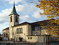
Catholic Church of St. Cyriak in Dielheim

Catholic Church in Balzfeld
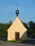
Chapel in the Oberhof (1787)


Regular events
- Dielheim Spring on April 30th
- Dielheimer Herbst (cultural event series in September)
- Dielheimer Kerwe (last weekend in September)
- Balzfelder " Geeleriewe " -Kerwe (November)
- Christmas markets in Dielheim, Horrenberg, Unterhof (Advent season)
- Whitsun tournament of the Reiterfreunde Horrenberg-Balzfeld eV
Economy and Infrastructure
traffic
The A 6 runs south of Dielheim . The L 612 runs through Dielheim and Horrenberg . There is a bus line to the surrounding towns. Dielheim belongs to the tariff area of the Rhein-Neckar transport association .
Historically, the branch line from Wiesloch- Walldorf via Wiesloch- Stadt, Alt-Wiesloch, Dielheim, Horrenberg, Baiertal and Schatthausen to Meckesheim , which opened on May 14, 1901 and whose passenger and freight traffic was shut down in 1990, is noteworthy. Already on October 16, 1901, it received a further section in the direction of Waldangelloch via Rauenberg , Rotenberg , Tairnbach, Mühlhausen , Eichtersheim , Michelfeld . The owner of this railway line Wiesloch – Meckesheim / Waldangelloch was originally the BLEAG ( Badische Lokal-Eisenbahnen AG) and from 1932 the Deutsche Eisenbahn-Betriebsgesellschaft (DEBG).
education

There is a primary school in Horrenberg. The Leimbachtal School in Dielheim is a community school with an intermediate level of education. There are other schools in nearby Wiesloch. The Catholic parish has a public library.
Personalities
Honorary citizen
Dielheim has awarded the following honorary citizenship:
- 1964: Martin Walter (1896–1987) was pastor in Dielheim for decades.
- 1978: Erhard Greulich (1914–1994) was mayor of Dielheim for 30 years.
- 1978: Hugo Epp (1913–1999) was mayor for 30 years or, after the incorporation, mayor of Horrenberg.
- 1979: Ludwig Englert (1914–1982) was pastor in Balzfeld-Horrenberg for 30 years.
- 1998: Kurt Laier (1922–2011) was a clerk at the community of Dielheim from 1945 to 1985.
- 2002: Bruno Gärtner was mayor of Dielheim for 24 years.
- 2010: Melitta Grün was a local councilor from 1975 to 2009, including 15 years as honorary deputy mayor.
- 2016: Heribert Leider was pastor in Dielheim from 1990 until his death in 2019
Sons and daughters of the church
- Jürgen Beyerer (* 1961), professor at the Karlsruhe Institute of Technology , managing director of the Fraunhofer Institute for Optronics, System Technology and Image Evaluation
- Steffi Laier (* 1985), multiple world champion in women's motocross, works driver in the KTM team
literature
- Ruth Greulich, Martin Bambach: 1200 years of Dielheim . Dielheim 1966
- State Archive administration Baden-Württemberg in connection with d. Cities and districts Heidelberg u. Mannheim (Hrsg.): The city and districts Heidelberg and Mannheim: Official district description .
- Vol 1: General part . Karlsruhe 1966
- Bd 2: The city of Heidelberg and the communities of the district of Heidelberg . Karlsruhe 1968
- Harald Gomille: The history of the community Dielheim: with Horrenberg, Balzfeld, Unterhof and Oberhof . Published by the community of Dielheim (self-published).
- Volume 1: 1994
- Volume 2: 1998
- Klaus Ronellenfitsch: Dielheimer Familienbuch 1648-1900, with Horrenberg, Balzfeld, Unterhof and Oberhof . Dielheim 2000 (= Badische Ortssippenbücher 85)
- Municipality: Dielheim in the anniversary year 2017
Individual evidence
- ↑ State Statistical Office Baden-Württemberg - Population by nationality and gender on December 31, 2018 (CSV file) ( help on this ).
- ↑ "Dielheim - Figures, Data, Facts"
-
↑ Sources for the section on community structure: Das Land Baden-Württemberg. Official description by district and municipality. Volume V: Karlsruhe District Kohlhammer, Stuttgart 1976, ISBN 3-17-002542-2 . P. 434–436
Main statutes of the community of Dielheim from May 18, 1987 ( page no longer available , search in web archives ) Info: The link was automatically marked as defective. Please check the link according to the instructions and then remove this notice. (PDF; accessed on August 20, 2008; 21 kB) - ↑ Minst, Karl Josef [trans.]: Lorscher Codex (Volume 2), Certificate 801, April 2, 767 - Reg. 121. In: Heidelberger historical stocks - digital. Heidelberg University Library, p. 296 , accessed on January 5, 2018 .
- ^ Federal Statistical Office (ed.): Historical municipality directory for the Federal Republic of Germany. Name, border and key number changes in municipalities, counties and administrative districts from May 27, 1970 to December 31, 1982 . W. Kohlhammer, Stuttgart / Mainz 1983, ISBN 3-17-003263-1 , p. 475 .
- ^ State Statistical Office of Baden-Württemberg: Municipal council elections 2019, Dielheim ; Municipality of Dielheim: municipal council election 2019 (PDF) ; accessed June 1, 2019.
- ↑ https://www.staatsanzeiger.de/staatsanzeiger/wahlen/buergermeisterwahlen/dielheim/
- ^ Herwig John, Gabriele Wüst: Wappenbuch Rhein-Neckar-Kreis . Ubstadt-Weiher 1996, ISBN 3-929366-27-4 , p. 42
Web links

Altlußheim | Angelbachtal | Bammental | Brühl | Dielheim | Dossenheim | Eberbach | Edingen-Neckarhausen | Epfenbach | Eppelheim | Eschelbronn | Gaiberg | Heddesbach | Heddesheim | Heiligkreuzsteinach | Helmstadt-Bargen | Hemsbach | Hirschberg an der Bergstrasse | Hockenheim | Ilvesheim | Ketch | Ladenburg | Laudenbach | Gluing | Lobbach | Malsch | Wall | Meckesheim | Mulhouse | Neckarbischofsheim | Neckargemünd | Neidenstein | Neulußheim | Nut hole | Oftersheim | Plankstadt | Rauenberg | Reichartshausen | Reilingen | Sandhausen | Schönau | Schönbrunn | Schriesheim | Schwetzingen | Sinsheim | Spechbach | St. Leon-Rot | Waibstadt | Walldorf | Weinheim | Wiesenbach | Wiesloch | Wilhelmsfeld | Zuzenhausen