Hude (Oldenburg)
| coat of arms | Germany map | |
|---|---|---|

|
Coordinates: 53 ° 7 ' N , 8 ° 28' E |
|
| Basic data | ||
| State : | Lower Saxony | |
| County : | Oldenburg | |
| Height : | 5 m above sea level NHN | |
| Area : | 124.64 km 2 | |
| Residents: | 16,111 (Dec. 31, 2019) | |
| Population density : | 129 inhabitants per km 2 | |
| Postal code : | 27798 | |
| Primaries : | 04408, 04484 | |
| License plate : | OIL | |
| Community key : | 03 4 58 010 | |
| Address of the municipal administration: |
Parkstrasse 53 27798 Hude (Oldenburg) |
|
| Website : | ||
| Mayor : | Holger Lebedinzew ( independent ) | |
| Location of the municipality of Hude (Oldenburg) in the district of Oldenburg | ||
Hude (Oldenburg) , officially Hude (Oldb) , is a municipality between Oldenburg (Oldb) and Bremen . It belongs to the district of Oldenburg in Lower Saxony and is one of the so-called Hude places .
geography
location
The community lies on the edge of the slightly hilly Wildeshauser Geest and is characterized by numerous streams and swampy terrain.
- Highest point in the area: 31.5 m above sea level. NHN (Hohenbökener Weg)
- Deepest terrain point: 0.2 m below sea level (Hollersiel)
Municipal area
The total area of the municipality is 124.6 km², 9290 hectares of which are used for agriculture. The remainder consists of woodland (1146 ha) and built-up areas as well as road land (898 ha).
Community structure
The following districts belong to the municipality of Hude:
|
history
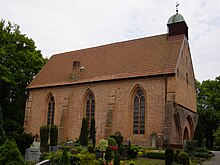
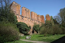
In 1232 Hude was first mentioned in the "Annales Cistercienses" on the occasion of the construction of the Cistercian monastery . In 1536 the monastery was closed and most of the monastery buildings were torn down, leaving almost nothing but ruins. The former gate chapel was preserved; it is today's Elisabethkirche, parish church of Hude. The former abbot house also still exists; after being used as a hunting lodge, it became a manor house.
In 1867 the Bremen – Oldenburg line was opened, and in 1873 the Hude – Nordenham line .
Until December 31, 2004, Hude belonged to the administrative district Weser-Ems , which was dissolved due to an administrative reform at the end of this date.
In August 2009, Hude celebrated its 777th anniversary.
Origin of the place name
Old names of the place are around 1232 (first mentioned) Hude an der Berne, 1234 Hudha and around 1242 Huda, Hudha, there also a village Hudermoor.
The word component -hude is contained in Hude bei Bremen, Ritterhude, Winterhude, Steinhude. It comes from the Middle Low German "hûde" and stands for "wood storage place, storage place at a water connection, ferry station". The word is related to the Old English "hyð" and means: "Space that the ship takes up on landing, a suitable low bank, a small harbor". The name is a family name that shows that the Germanic colonists of England came primarily from Lower Saxony. More than 100 years ago, the linguist Hermann Jellinghaus assumed that the -hude names were "a strong testimony to the origin of the tribe of the southern English population from the Low German plain".
Incorporations
On July 1, 1972, the previously independent municipality of Wüsting was incorporated into the municipality of Hude as part of the regional reform in Lower Saxony .
Population development
|
|
¹ as of December 31st

|
politics
Municipal council
The council of the municipality of Hude consists of 32 council women and councilors. This is the specified number for a municipality with a population between 15,001 and 20,000. The council members are elected for a five-year term by local elections. The current term of office began on November 1, 2016 and ends on October 31, 2021.
The full-time mayor is also entitled to vote and sit in the municipal council.
The last local election on September 11, 2016 resulted in the following:
| Political party | Proportional votes | Number of seats |
|---|---|---|
| CDU | 32.72% | 11 |
| SPD | 32.63% | 10 |
| Alliance 90 / The Greens | 13.72% | 4th |
| FDP | 11.99% | 4th |
| Free voters | 4.72% | 2 |
| The left | 4.19% | 1 |
The turnout in the 2016 local elections was 60.63%, above the Lower Saxony average of 55.5%.
mayor
In the last mayoral election on June 15, 2014, Holger Lebedinzew ( independent ) won the runoff election for full-time mayor with 54.8%, ahead of Uta Rose with 45.2%. The turnout was 46.6%. Lebedinzew took office on November 1, 2014, replacing Mayor Axel Jahnz (SPD), who had been in office since 1998, and who ran and was elected mayor of Delmenhorst .
coat of arms
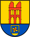
Municipal coat of arms (after the incorporation of Wüsting)
| Blazon : "Above a blue shield base , in the heel part a golden shield covered with a blue square , inside four golden windmill blades with black wing rods and a red axis , a red church ruin in gold with twopointed arches supportedby pillars , above each two small pointed arches." | |
| Foundation of the coat of arms: The former Cistercian monastery is commemorated in the upper part of the municipal coat of arms . In the lower part of the coat of arms, the four windmill blades symbolize the scoop mills of that time, which shaped the landscape of the municipality. Dutch settlers set up these distinctive mills and dug drainage ditches around their fields, since in the wet years the inland water of the former Bailiwick of the desert did not flow away. The colors gold, red and blue in the municipal coat of arms indicate the coat of arms colors of Oldenburg. |
Municipal coat of arms (before the incorporation of Wüsting)
The former municipal coat of arms of the municipality of Hude comes from the heraldist Manfred Furchert . The coat of arms was awarded in 1948 by the Lower Saxony Minister of the Interior .
| Blazon : "Over blue sign foot in gold a red ruin wall with three pillars; two pointed arched gates on the ground floor, two pairs of pointed archedwindows above. " | |
| Justification of the coat of arms: The former monastery is commemorated in the community's coat of arms. The colors of gold, red and blue in the municipal coat of arms should allude to the coat of arms colors of Oldenburg. |
Partnerships
The partner communities of the community of Hude are:
| city | country | since |
|---|---|---|
| Arnage |
|
1983 |
| Kröpelin |
|
1991 |
| Fiume Veneto |
|
2002 |
| Nowe Miasto Lubawskie |
|
2003 |
| Šalčininkai |
|
Culture and sights
Buildings
St. Elisabeth Church
Today's Evangelical Lutheran St. Elisabeth Church was built around 1300 as the gate chapel of the Cistercian monastery. The early Gothic brick building has served as a Protestant parish church since around 1548. It contains wall paintings from the time it was made and a pulpit from 1672. In the cemetery next to the church there is a memorial stone for Field Marshal Erwin von Witzleben , who was executed for participating in the resistance of July 20, 1944.
Hude Monastery
The monastery was founded by the Cistercian order in 1232. Parts of the former three-aisled monastery church, as well as the gate chapel (today St. Elizabeth's Church) and the abbey have been preserved from the complex, built in the brick Gothic style in the 13th century.
Marienhude refinery and house
In the southern part of Hude there was a refinery for the production of gasoline around 1900 , which was sold under the name Hudolin . The factory was the main factory of the Bremen company "Chemische Fabriken AG" and was in operation until 1933. After the end of operations, large parts of the factory were demolished and houses were built in their place. All that remains of the factory is the “Haus Marienhude” villa , built in 1905 , which, after several other uses, was converted into an educational facility for community service in 1986 under the sponsorship of the Diakonisches Werk of the Evangelical Church in Oldenburg.
Sculpture bank
To the south of the center of Hude, 45 sculptures are set up in the open on a 1.4 hectare meadow parallel to the Huder Bach. The Hude sculpture bank was opened on May 31, 1992. It was created through collaboration between the Hude community, the action group for Hude and the sculptor Wolf E. Schultz , who has lived in Hude since 1983. A forerunner of the sculpture bank is the sculpture path laid out in 1985.
Planet path
A planetary nature trail leads from Wüsting (sun) to Hude (Pluto). It is laid out on a scale of 1: 1 billion and is intended to illustrate the proportions of our solar system and make it tangible. The path length is therefore around 6 km. The model of the sun consists of an ARIANE-5 tank, the planets are represented on bronze plaques that line up along the path.
Sports
In the community you can be active in a number of clubs in a variety of ways. The gymnastics club Hude von 1895 eV even has a wheelchair dance group .
Economy and Infrastructure
Agricultural structure
The number of farms (as of 1995) is 323. Of these, more than a third of the farms have a minimum size of 30 ha.
Economic structure
The Amazonen-Werke (agricultural machinery) and the Labom company (industrial measurement technology) are represented in Hude as major employers of supraregional importance . In addition, a number of smaller businesses are of national importance.
Employees subject to social insurance at work
There are a total of 2678 (as of June 30, 2005) employees in the municipality who are subject to social security contributions. Most are active in energy, water, mining and manufacturing (1542), while only around 100 people work in agriculture.
traffic
The Hude train station is served by regional trains / Regional Express on the Nordenham – Bremen and Oldenburg – Bremen routes. Since December 12, 2010, Hude has been connected to the Bremen S-Bahn network with two lines .
Since December 16, 2013, the station has also been connected to the long-distance network of Deutsche Bahn. The Intercity trains from / in the direction of Bremen – Hannover – Leipzig stop here. As a special feature, this IC can be used west of Bremen with local transport tickets and without a surcharge.
Personalities
Sons and daughters of the church
- Friedrich Lohse (1872–1931), politician (DVP), member of the state parliament
- Heinz Witte-Lenoir (1880–1961), painter, born in Lintel
- Johann Blankemeyer (1898–1982), politician (NSDAP), member of the Reichstag, born in Kirchkimmen
- Helmut Poppendick (1902–1994), doctor, head of the personal staff at the Reichsarzt SS and police
- Ralf Voigt (* 1964), soccer coach and former soccer player
People connected to the community
- Gerd Achgelis (1908–1991), stunt pilot, died in Hude
- Stuart Heydinger (1927–2019), British press photographer, died in Hude
Web links
- Hude municipality
- Link catalog on the subject of Hude at curlie.org (formerly DMOZ )
Individual evidence
- ↑ State Office for Statistics Lower Saxony, LSN-Online regional database, Table 12411: Update of the population, as of December 31, 2019 ( help ).
- ^ Cistercian monastery in Hude. In: klosterhude.de. Retrieved April 21, 2020 .
- ^ Jürgen Udolph (research): The "place name researcher". In: Website NDR 1 Lower Saxony . Archived from the original on November 27, 2015 ; accessed on August 4, 2019 .
- ^ Federal Statistical Office (ed.): Historical municipality directory for the Federal Republic of Germany. Name, border and key number changes in municipalities, counties and administrative districts from May 27, 1970 to December 31, 1982 . W. Kohlhammer, Stuttgart / Mainz 1983, ISBN 3-17-003263-1 , p. 276 .
- ^ A b Michael Rademacher: German administrative history from the unification of the empire in 1871 to the reunification in 1990. Office Delmenhorst. (Online material for the dissertation, Osnabrück 2006).
- ^ Ulrich Schubert: Municipal directory Germany 1900 - Delmenhorst office. Information from December 1, 1910. In: gemeindeververzeichnis.de. January 5, 2020, accessed April 23, 2020 .
- ↑ a b Statistisches Bundesamt Wiesbaden (ed.): Official municipality register for the Federal Republic of Germany - 1957 edition (population and territorial status September 25, 1956, for Saarland December 31, 1956) . W. Kohlhammer, Stuttgart 1958, p. 210 ( digitized version ).
- ↑ Lower Saxony State Administration Office (ed.): Municipal directory for Lower Saxony . Municipalities and municipality-free areas. Self-published, Hanover January 1, 1973, p. 60 , district of Oldenburg ( digitized version ( memento from August 7, 2019 in the Internet Archive ) [PDF; 21.3 MB ; accessed on June 22, 2020]).
- ↑ a b c d e f g h i j community directory - archive - regional structure - annual editions - Lower Saxony. (All politically independent municipalities in EXCEL format). In: Destatis website. Federal Statistical Office, accessed on April 23, 2020 .
- ↑ a b c Hude municipality - overall results of the 2016 municipal council election. In: Website Zweckverband Kommunale Datenverarbeitung Oldenburg (KDO). September 11, 2016, accessed January 20, 2017 .
- ^ Lower Saxony Municipal Constitutional Law (NKomVG); Section 46 - Number of Deputies. In: Lower Saxony Regulations Information System (NI-VORIS). December 17, 2010, accessed April 21, 2020 .
- ↑ The CDU gets the most votes nationwide. In: Website Norddeutscher Rundfunk . September 12, 2016. Retrieved January 20, 2017 .
- ↑ Klaus Derke: runoff - Lebedinzew is mayor. In: Website Nordwest-Zeitung . June 16, 2014, accessed April 21, 2020 .
- ^ Main statute of the municipality of Hude. (PDF; 129 kB) § 2; Coats of arms, colors and seals; Paragraph 1. In: Website of the municipality of Hude (Oldb). February 22, 2019, p. 1 , accessed April 22, 2020 .
- ↑ Drawings of the coat of arms by Manfred Furchert. In: Wikimedia Commons. Retrieved April 22, 2020.
- ↑ a b Manfred Furchert: Oldenburgisches crests . The coats of arms of the districts, cities and municipalities of the Oldenburger Land. tape 1 . Isensee Verlag, Oldenburg 2003, ISBN 3-89995-050-X , p. 92 .
- ^ Partnership work of the community of Hude. (PDF; 46 kB) In: Website of the municipality of Hude (Oldb). October 2004, archived from the original on March 4, 2016 ; accessed on April 21, 2020 .
- ^ Entry about the twin town Šalčininkai. In: Website of the municipality of Hude (Oldb). Retrieved April 21, 2020 .
- ↑ Sculpture Bank . In: Website of the municipality of Hude (Oldb). Archived from the original on May 2, 2009 ; accessed on April 21, 2020 .
- ^ Hude planetary teaching path. In: planetarium.hs-bremen.de. Retrieved April 21, 2020 .
- ↑ Fleet dances on feet and on wheels. In: Website Nordwest-Zeitung. February 28, 2011, accessed April 21, 2020 .
- ↑ Ute Winsemann: Upgrade for commuters and long-distance travelers - IC stops in Hude from Sunday. In: Website Weserkurier . December 9, 2013, accessed April 21, 2020 .
- ^ Information from the VBN - Tickets - IC / EC surcharges. In: vbn.de. Retrieved April 21, 2020 .


