Johnston Atoll
| Johnston Atoll | |
|---|---|
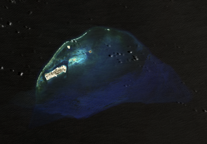
| Satellite image of the Johnston Atoll | |
| Waters | Pacific Ocean |
| Geographical location | 16 ° 44 ′ N , 169 ° 32 ′ W |
| Number of islands | 4th |
| Main island | Johnston Island |
| Land area | 2.67 km² |
| Lagoon area | 130 km² |
| Residents | uninhabited |
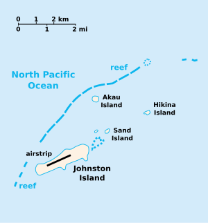
| Map of the Johnston Atoll | |
The Johnston Atoll (old name Cornwallis Island ) is an atoll in the northern Pacific Ocean , 1150 km southwest of Hawaii . The archipelago belongs politically to the United States and is counted by these as so-called "non-incorporated territory" to the United States Minor Outlying Islands .
geography
The 2.67 km² archipelago consists of the two heavily man-made islands Johnston Island and Sand Island as well as the two artificial islands Akau in the north and Hikina in the east. A coral reef lies in front of the islands in the northwest . The area of the lagoon is 130 km². There are no natural freshwater springs on the atoll. The main island of Johnston Island had around 317 inhabitants until 2004, mainly US military, but is now uninhabited. The atoll is only a few meters above sea level , the highest point protruding just five meters from the water. The climate is hot, dry and windy year round, with northeast trade winds predominating. In the 19th century, the extensive guano deposits that were previously used as fertilizer were removed.
history
The Johnston Atoll was discovered on September 2, 1796 by Captain Joseph Pierpoint on the American brig Sally and was sighted again in 1807 by the British ship's captain Charles James Johnston of the HMS Cornwallis , who called the island Cornwallis Island. On March 19, 1858, the islands were taken over for the United States under the Guano Islands Act , but were annexed by the Hawaiian King Kamehameha IV on July 27, 1858 . 1898, the island group was again a part of the United States, they 1958 to 1975 as a launch site used, with the launcher at 16 ° 44 '15 " N , 169 ° 31' 26" W was located.
Rockets for high-atmospheric tests of hydrogen bombs were also launched from Johnston Island . For example, on August 1, 1958, as part of Operation Hardtack, a Redstone rocket with a 3.8 megaton warhead was launched for the purpose of a nuclear weapon test at an altitude of 77.8 km. Further rockets for high-atmospheric atomic bomb tests were launched from Johnston Island on August 12, 1958 at an altitude of 43 km and on July 9, 1962 as part of Operation Starfish Prime (as part of Operation Dominic ), the EMP occurring numerous electrical and electronic devices on Oahu (Hawaii) bothered.
This launch should have been carried out on June 20, 1962, but then the rocket exploded at a height of 10 km. The neighboring Sand Island was contaminated with plutonium . During a launch attempt on July 26, 1962, the rocket with the nuclear warhead exploded on the launch pad, destroying it and contaminating the surrounding area with plutonium. This led to an almost quarter-year break in experiments. These were resumed on October 16, 1962, but again failed. The Thor DSV-2E missile exploded at a height of 10 km, with some fallout from falling on Johnston Island.
More rockets for the purpose of high-atmospheric nuclear bomb tests were launched:
| date | Launch rocket | Warhead | Explosion height |
|---|---|---|---|
| October 20, 1962 | Strypi | 60 kT | 147 km |
| October 26, 1962 | Thor DSV-2E | 300 kT | 50 km |
| November 1, 1962 | Thor DSV-2E | 300 kT | 98 km |
| 4th November 1962 | Nike Hercules | some kT | 21 km |
After above-ground nuclear weapons tests were no longer possible, numerous research rockets (also for civil research) were launched from Johnston Island at heights of up to 1148 km until 1975 .
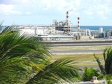
The island served as a warehouse for chemical warfare agents such as sarin and Agent Orange from 1971 . At the end of the 1980s, a plant, the Johnston Atoll Chemical Agent Disposal System (JACADS) , was built on the island for the combustion of chemical warfare agents and dismantled again in 2003 after the completion of the measures. In the early 1990s , chemical weapons previously stored in the Palatinate were also destroyed in the course of the Lindwurm campaign .
At the end of 2003 the islands were evacuated by the military and the management was transferred to the US Fish & Wildlife Service on January 1, 2004 . This created the nature reserve Johnston Atoll National Wildlife Refuge and incorporated it into the Pacific Remote Islands National Wildlife Refuge Complex .
In 2005 the atoll was offered for sale by the General Services Administration (GSA), but the offer was withdrawn due to an environmental impact statement .
Johnston Atoll Airport (ICAO code PJON ) has been out of service since 2005 and can only be used for unscheduled emergency landings.
Since January 6, 2009, the nature reserve of the Johnston Atoll has formed the Pacific Remote Islands Marine National Monument together with six other American islands in the Pacific .
literature
- Ralph Gerard Ward (Ed.): American activities in the central Pacific, 1790-1870. A history, geography and ethnography pertaining to American involvement and Americans in the Pacific taken from contemporary newspapers, etc. Volume 3 : Gaferut to Kwajalein . Gregg Press, Ridgewood, New Jersey 1967 (English).
Web links
- Johnston Atoll National Wildlife Refuge. In: National Wildlife Refuge System. United States Fish and Wildlife Service (English).
- Maps of Australia and the Pacific. Further maps of the Johnston Atoll in the Perry-Castañeda Library Map Collection of the University of Texas at Austin (English).
Individual evidence
- ↑ Richard W. Grigg, Charles Birkeland (Ed.): Status of Coral Reefs in the Pacific . Sea Grant College Program, School of Ocean and Earth Science and Technology, University of Hawaii, June 1997, Table 6: Summary data on miscellaneous islands and coral reefs of the Central Pacific (Nauru, Tokelau, Tuvalu, and US Line and Marshall Is. ) , P. 12 (English, online in the National Sea Grant Library of the University of Rhode Island [PDF; 8.3 MB ]).
- ↑ CIA World Factbook: United States Pacific Island Wildlife Refuges: Johnston Atoll. Retrieved June 3, 2017.
- ↑ World Atlas and Country Lexicon, Tandem-Verlag GmbH.
- ^ Johnston Island. In: Jane's Oceania Home Page. Jane Resture, accessed June 3, 2017 .
- ^ Operation Dominic. In: nuclearweaponarchive.org. Retrieved June 3, 2017 .
- ↑ Johnston Island - List of all rocket launches in the Encyclopedia Astronautica , accessed on June 3, 2017 (English).
- ↑ Keith Schneider: US plan to burn chemical weapons stirs public fear. In: The New York Times . April 29, 1991, accessed June 3, 2017.
- ↑ Gregg K. Kakesako: Johnston Atoll: The end of an era. In: Honolulu Star Bulletin. Oahu Publications Inc., November 6, 2003, accessed June 3, 2017.
- ^ William L. Robinson (Ed.): Draft Programmatic Environmental Impact Statement. Towards an Ecosystem Approach for the Western Pacific Region: From Species-based Fishery Management Plans to Place-based Fishery Ecosystem Plans . National Marine Fisheries Service, Honolulu October 27, 2005 (English, online, ( Memento from October 2, 2006 in the Internet Archive ) Memento from October 2, 2006 in the Internet Archive [PDF; 227 kB ; accessed on June 3, 2017]).
- ^ US Unincorporated Possessions. Johnston Atoll. In: World Statesmen.org. Retrieved June 3, 2017 .


