M8 (Russia)
| Main thoroughfare of federal importance | ||
|
||
| M8 Cholmogory | ||
|---|---|---|
| Basic data | ||
| Overall length: | 1271 km | |
|
Federation subjects : |
|
|
| Development condition: | two, four and six lanes | |
| European route : | E 115 | |
| map | ||
|
|
||
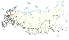
The M8 ("Cholmogory") is a Russian trunk road. It leads across the Yaroslavler Chaussee out of Moscow in a north-easterly direction via Yaroslavl and Vologda to Arkhangelsk and on to Severodvinsk on the White Sea . It is part of the European route 115 between Moscow and Yaroslavl .
course

Junction of the M8 and the Moscow ring road

M8 at Rostov Veliky
- 0 km - Moscow
- 17 km - Pushkino
- 27 km - Lesnoi , crossing the A107
- 58 km - Sergiev Posad , crossing the A108
- 80 km - Dworiki , junction of the R75 in the direction of Alexandrov (25 km)
- 123 km - Pereslavl-Zalessky
- 165 km - Petrovskoye
- 189 km - Rostov
- 218 km - Schopscha
- 246 km - Yaroslavl, branch line to Kostroma , from there further as R600 (until 2017 also A113)
- 292 km - Tufanowo
- 315 km - Danilov
- 344 km - Pretschistoje
- 396 km - Gryazovets
- 441 km - Vologda
- 468 km - Sokol
- 476 km - Kadnikow
- 505 km - Chekschino
- 556 km - Mikhailovskoye
- 607 km - Schelota
- 642 km - Smetanino
- 661 km - Verkhovashye
- 720 km - Welsk
- 805 km - Rowdino
- 860 km - Schipunovskaya , turnoff to Schenkursk (6 km)
- 963 km - Bereznik
- 1152 km - Kholmogory
- 1232 km - Arkhangelsk
- 1267 km - Severodvinsk
Web links
Commons : M8 - collection of pictures, videos and audio files

