Newfoundland and Labrador
| coat of arms | flag |
|---|---|
 ( Details ) |
 ( Details ) |
|
Motto : Quaerite Primum Regnum Dei "Seek first the kingdom of God" |
|
| location | |
| Basic data | |
| Official language | English |
| Capital | St. John's |
| Biggest town | St. John's |
| surface | 404,517 km² (10.) |
| Population (2016) | 530.128 (9.) |
| Population density | 1.2 inhabitants / km² |
| GDP in CAD (2006) | Total: 24.897 million (9th) Per capita: 47,520 (4th) |
| Time zone |
UTC −3.30 ( Newfoundland ) UTC −4 ( Labrador ) |
| ISO 3166-2 | CA-NL |
| Postal abbreviation | NL |
| Website | www.gov.nl.ca |
| politics | |
| Joined Confederation | March 31, 1949 |
| Deputy Governor | Frank Fagan |
| prime minister | Andrew Furey |
| Sit in the lower house | 7th |
| Seat in the Senate | 6th |
Newfoundland and Labrador (English Newfoundland and Labrador [ n (j) uːfən (d) ˈlænd‿ænd ˈlæbɹədɔɹ ], French Terre-Neuve-et-Labrador [ tɛʁ nœv‿e labʁaˈdɔʁ ], 1949-2001 Newfoundland ) is one of the Atlantic provinces in eastern Canada . The independent Dominion Newfoundland was not attached to Canada until 1949.
Geography and location
geography
The Avalon Peninsula is the namesake for the microcontinent Avalonia , which split off from Gondwana and connected with Baltica 435 million years ago . Before the formation of the Atlantic, Newfoundland was therefore close to Scotland , Scandinavia and Morocco , which have a similar orogeny and topology . The Long Range Mountains are the northernmost extension of the Appalachian Mountains .
location
Newfoundland and Labrador is bordered by Québec to the west and the Atlantic to the east . It consists of a mainland part, which is located on the Labrador Peninsula , and the fjord and lake-rich island of Newfoundland with its many smaller offshore islands, for example Bell Island and Twillingate Islands . Newfoundland is the easternmost part of North America, closest to Europe , and rich in historical and geographical features.
history
European discovery
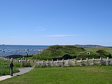
Newfoundland was discovered by the Viking Leif Eriksson as the first European and at what is now L'Anse aux Meadows (now a UNESCO World Heritage Site ) there was also a Viking settlement for a short period of time. There has been isolated speculation in the specialist literature as to whether Basque whalers, who appeared in the waters off Newfoundland from around the 1530s, might have landed in Newfoundland or Labrador before Columbus and John Cabot . So far there is no convincing evidence for this. According to a legend from the 9th / 10th Century Navigatio Sancti Brendani ("The Seafaring of St. Brendan "), this Irish abbot is said to have undertaken an Atlantic voyage to the west with several other monks as early as the 5th century and to have landed on the Saint Brendan Islands . Newfoundland and Labrador were also associated with this, but there is no archaeological evidence for this either.
The first early modern European explorer of Newfoundland and Labrador is Giovanni Caboto (John Cabot), who went on a voyage of discovery on behalf of the English King Henry VII and possibly landed at Cape Bonavista on the east coast of Newfoundland on June 24, 1497 . However, other locations in Newfoundland, Labrador, and Nova Scotia are believed to be possible. A short time later, in 1499 and 1500, the Portuguese navigators João Fernandes Lavrador and Pêro de Barcelos followed , who explored and mapped the coast. The former was named after Labrador. With reference to the Treaty of Tordesillas in 1494, Portugal raised a claim to Labrador, as it was assumed to be east of the dividing line and thus in the Portuguese area of interest.
In the years 1500 and 1501 there were Portuguese expeditions of the two brothers Miguel and Gaspar Corte-Real to Terra Verde (probably Newfoundland). Other seafarers from other countries followed. In 1524 Giovanni da Verrazzano , an Italian navigator in the service of King Francis I of France, explored the area around Newfoundland, and in 1624-25 the Portuguese navigator in Spanish service, Estevão Gomes and John Rut , sailed on behalf of King Henry VIII. of England the sea areas around Newfoundland. The two trips Jacques Cartier made in 1534 and 1535–36 on behalf of the French were of great importance . He discovered the Gulf of St. Lawrence and was the first to sail the St. Lawrence River . From the second half of the 16th century and in the following centuries, many voyages of discovery concentrated on the discovery of a " Northwest Passage " to Asia. The waters around Newfoundland became of particular interest for their rich fish and whale populations. Initially, Basque, Spanish, Portuguese and French fishermen dominated here. From the second half of the 16th century, English fishing vessels began to play an increasingly important role, and Spanish and Basque fisheries were decimated and increasingly displaced , particularly by English privateers such as Bernard Drake .
English or British colony
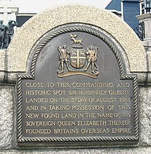
In 1583 Newfoundland was formally declared an English possession. The first permanent English settlements existed in the following decades, including today's capital St. John's . From the second half of the 17th century, the Anglo-Spanish rivalry was replaced by the Anglo-French rivalry. The English possession in Newfoundland was threatened by the nearby French colony of Canada and was repeatedly the site of war. During King William's War (1689-1697), which took place as a North American secondary theater of war in Europe in parallel to the Palatinate War of Succession , the English settlements on Newfoundland were almost completely devastated by the French commander Pierre Le Moyne d'Iberville . This threat only ended when France lost all of its possessions in Canada to Great Britain in the Seven Years' War 1756–1763.
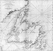
From 1763 to 1767, James Cook undertook a detailed survey of the Newfoundland and Labrador coastlines.
Dominion Newfoundland 1907-1934 and the years up to 1949
From 1907 to 1934, Newfoundland and Labrador were an independent Dominion in the British Empire . Due to the turmoil resulting from the Great Depression of 1929 and political instability, the government agreed to dissolve itself in 1934. The mother country Great Britain regained control and the area was downgraded to the status of a British Crown Colony. After the Second World War, various options arose:
- remaining as a British colony,
- the regaining of Dominion status, de facto independence within the framework of the Commonwealth of Nations ,
- the connection to neighboring Canada and
- an economic or even political union with the United States.
In a referendum on July 22, 1948, the voters voted with a narrow majority of 52.3% against independence and in favor of joining Canada. The union was completed on March 31, 1949.
German missionaries of the Moravian Brethren played a role for the Inuit in Labrador for a long time . The first transatlantic flights and transatlantic telecommunications ( Marconi ) are linked to the history of Newfoundland, as are the only enemy contacts with Germany in World War II and the most devastating seaquake and tsunami in Canadian history (1929 Burin Peninsula ). Gander Airport has long been an important refueling point in transatlantic air traffic and an occasional escape route for GDR citizens in transit to and from Cuba . Labrador served the German Air Force as a training area until 2007.
climate

The climate is unstable at the confluence of the Gulf Stream and the Labrador Stream with icebergs caught in bays in summer (see also Titanic sinking in 1912 off Newfoundland). Hurricanes often leave the American continent over the province to arrive in Europe as extratropical hurricanes .
The climate on the mainland is characterized by the cold Labrador Current, whereas the southeast of the island of Newfoundland in particular benefits from the foothills of the Gulf Stream and has a much warmer climate.
population
The total population is 514,536 (as of 2011), of which 59% (305,566) live in cities and 41% (208,970) in rural areas. English is spoken by around 98% of the population, around 0.4% speak French . There is also a small part of the population that speaks Algonquin languages .
| year | Residents |
|---|---|
| 1951 | 361,416 |
| 1956 | 415.074 |
| 1961 | 457.853 |
| 1966 | 493,396 |
| 1971 | 522.100 |
| 1976 | 557.720 |
| 1981 | 567,681 |
| 1986 | 568,350 |
| 1991 | 568,475 |
| 1996 | 551.790 |
| 2001 | 512.930 |
| 2006 | 505.469 |
| 2011 | 514,536 |
| 2016 | 519.716 |
Source: Statistics Canada
religion
| religion | number | % |
|---|---|---|
| Catholics | 181,585 | 35.80 |
| Anglican | 127,250 | 25.08 |
| United Church of Canada | 78,380 | 15.45 |
| Pentecostal churches | 33.195 | 6.54 |
| Religionless | 31,330 | 6.18 |
| Other Christs | 50,555 | 9.97 |
| Muslims | 1,200 | 0.24 |
| Other religions | 2,020 | 0.40 |
Cities

| local community | 2001 | 2006 | 2011 |
|---|---|---|---|
| St. John's | 99.182 | 100,646 | 106.172 |
| Conception Bay South | 19,772 | 21,966 | 24,848 |
| Mount Pearl | 24,964 | 24,671 | 24,284 |
| Corner Brook | 20,103 | 20,083 | 19,886 |
| Paradise | 9,598 | 12,584 | 17,695 |
| Grand Falls-Windsor | 13,340 | 13,558 | 13,725 |
| Gander | 9,651 | 9,951 | 11,054 |
| Happy Valley-Goose Bay | 7,969 | 7,572 | 7,552 |
| Labrador City | 7,744 | 7,240 | 7,367 |
| Stephenville | 7.109 | 6,588 | 6,719 |
| Source: Statistics Canada | |||
Other significant locations are: Ferryland , Gander , Corner Brook , Placentia , Grand Falls-Windsor , Deer Lake , Stephenville , Channel-Port aux Basques , St. Anthony , Happy Valley-Goose Bay , Labrador City , L'Anse-au-Clair .
politics
The Newfoundland and Labrador political system is based on the Westminster system with a unicameral parliament. The House of Representatives consists of 48 members who are elected by majority voting in as many constituencies . The lieutenant governor , who represents the head of state, can, in consultation with the prime minister, dissolve parliament ahead of time and call new elections, in accordance with British parliamentary tradition. The prime minister is always the leader of the party that has won the most seats. This office is currently held by Paul Davis and Lieutenant Governor Frank Fagan .
In the Canadian House of Newfoundland and Labrador will be represented by seven deputies. According to the Canadian Constitution , the province has six seats in the Senate .
economy

After a period of prosperity in the 19th century, Newfoundland and Labrador had a long stagnant economy. Mainly due to the collapse of the fish stocks at the beginning of the 1990s, the unemployment rate skyrocketed, which led to around 60,000 people leaving the province. However, this changed due to the great energy and raw material boom in recent years (as of 2016). The unemployment rate fell, the population stabilized and at the end of the day there was even a slight increase.
The most important economic sectors include services, raw materials and tourism. There is an iron ore mine in Labrador and a nickel mine in Voisey's Bay. The two mines generated commodities with a value of 3.3 billion CAD in 2010. Another mine in Duck Pond began in 2007 with the production of copper , zinc , silver and gold . The province of Newfoundland supplies 55% of Canada's iron needs. The quarries extract stone , slate and granite for a total of ten million CAD per year. Furthermore, oil production plays a major role in the economy. There are several oil fields and offshore oil platforms that produce oil off the coast. The main mining areas are the Hibernia, White Rose and Terra Nova oil fields on the Grand Banks of Newfoundland . The largest employer in the manufacturing industry is the J. D. Irving group of companies . The company has several locations and employs over 15,000 people. Another major food company is McCain . The service factor also plays an essential role in the province, especially financial services, healthcare and public institutions. In 2010 around 263,800 people were employed in these areas. There were around 299,936 tourists in tourism in 2012. The number of tourists increases significantly, especially in the warm months between June and September.
Education and Research
There are several universities and colleges in the province. Memorial University of Newfoundland in St. John's is one of the largest with over 18,000 students. In addition to the main campus in St. John's, the university has other locations in the province. The university offers bachelor's and master's degrees. Other universities are the Western College and the College of the North Atlantic in Stephenville .
Transport infrastructure

Ship connections
In the province, the Newfoundland and Labrador Department of Transportation operates several ferry lines of its own that connect several cities on the coast. In addition to the normal passenger ferries, car ferries also operate. Other ferries are offered by private transport companies.
A regular ferry runs across the Belle Isle Strait and connects the island of Newfoundland with the Labrador region on mainland Canada, including the towns on its route.
Flight connections
The St. John's International Airport and the Gander International Airport are two airports in the National Airport System. St. John's Airport has more than 1.2 million passengers a year. The airport is currently being massively expanded in order to cope with the capacity. It will u. a. a new terminal building is being built, which is due to be completed by 2021. St. Johns International Airport is the eleventh largest in Canada.
Road links
The main highways that connect the province with the rest of the country are primarily the Trans-Canada Highway and the Trans-Labrador Highway .
railroad
The railway line from St. John's to Port aux Basques opened in 1898. It has since been shut down. Quebec North Shore & Labrador Railway offers a connection from Sept-Îles (Québec) to Labrador . Unlike most other provinces in Canada, Newfoundland and Labrador is not served by the national railway company VIA Rail Canada .
Web links
- Website of the provincial government (Engl.)
- Newfoundland and Labrador ( English, French ) In: The Canadian Encyclopedia .
Individual evidence
- ↑ Alex Aguilar: A review of old Basque whaling and its effect on the right whales of the North Atlantic . In: Report - International Whaling Commission . tape 10 , no. January 10 , 1986, pp. 191–199 (English, full text at ResearchGate (login required): online ).
- ↑ Bailey W. Diffie, George D. Winius: Foundations of the Portuguese empire . University of Minnesota Press, 1977, ISBN 0-8166-0782-6 , pp. 464 (English, Google preview ).
- ^ Exploration and Settlement. heritage.nf.ca, accessed on September 13, 2017 .
- ^ The International Fishery of the 16th Century. heritage.nf.ca, accessed on September 13, 2017 .
- ↑ a b Census 2011. Population, urban and rural, by province and territory. Statistics Canada , February 4, 2011, accessed November 17, 2015 .
- ↑ 2011 National Household Survey. Religion, Immigrant Status and Period of Immigration. Statistics Canada , February 14, 2017, accessed March 17, 2018 .
- ↑ Population by municipality - Statistics Canada 2011.
- ^ Article in The Globe and Mail of December 17, 2011, accessed October 29, 2012.
- ↑ Tourism Performance Newfoundland and Labrador 2012 ( page no longer available , search in web archives ) Info: The link was automatically marked as defective. Please check the link according to the instructions and then remove this notice. Department of Tourism, Culture and Recreation (TCR).
- ^ L Blanc Sablon (Labrador Straits Area) - St. Barbe . Department of Transportation and Works. Retrieved July 30, 2012.
- ↑ Passengers enplaned and deplaned on selected services - Top 50 airports . Statistics Canada. Retrieved August 29, 2011.
- ↑ Airport Authority Unveils its 10-year Vision for Airport Improvements . St. John's International Airport Authority. Archived from the original on June 20, 2012. Retrieved July 30, 2012.
Coordinates: 52 ° 37 ′ N , 59 ° 41 ′ W


