
March shaft
| coat of arms | Germany map | |
|---|---|---|

|
Coordinates: 53 ° 25 ' N , 10 ° 22' E |
|
| Basic data | ||
| State : | Lower Saxony | |
| County : | Harburg | |
| Joint municipality : | Elbe March | |
| Height : | 4 m above sea level NHN | |
| Area : | 26.12 km 2 | |
| Residents: | 3940 (Dec. 31, 2019) | |
| Population density : | 151 inhabitants per km 2 | |
| Postal code : | 21436 | |
| Primaries : | 04176, 04133 | |
| License plate : | WL | |
| Community key : | 03 3 53 023 | |
| LOCODE : | DE MRT | |
| Community structure: | 5 districts | |
| Address of the municipal administration: |
Elbuferstraße 98 21436 Marschacht |
|
| Website : | ||
| Mayor : | Rodja Gross ( SPD ) | |
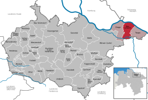
| Location of the municipality of Marschacht in the Harburg district | ||
  |
||

The municipality of Marschacht is located in the center of the Lower Saxony joint municipality of Elbmarsch in the Harburg district about 30 km southeast of Hamburg and about 10 km northeast of Winsen (Luhe) on the Elbe .
history

The original church village was first mentioned in 1216 as "Hachede" . In this document from 1216, Count Albrecht von Orlamünde, governor of the Danish King Waldemar II, granted the citizens of Hamburg exemption from customs at some customs offices, including Hachede. In the Ratzeburg tithe register of 1230, the name of the parish place is "Hagede" , although this spelling apparently reflects the older phonetic form of the place name. It is based on a formation from the old Saxon field name * hag-: "fence, enclosure, hedge, pasture" and the widespread place name suffix -ithi, -ithja (* hag-ithi> * hag-ede). Due to the name formation, the first settlement can be expected in the 9th century at the latest. getting closed. A change in the course of the river cut the place in two, creating the older Hacht an der Geest ( Geesthacht ) north of the Elbe and a younger Hacht an der Marsch (Marschacht) south of the Elbe . It is believed that the old village could have been cut up by the Elbe river as early as the 12th century. The final separation of these two places is said to have taken place at the latest in the middle of the 13th century, when the common church sank in the Elbe (between 1230 and 1258).
Marschacht probably had its own church as early as 1258, because the contract for the cultivation of the marshland from 1258 describes the expansion of the marsh from Bleckede to the parish of Hachede (" palus a Blekethe vsque ad ecclesiam Hachede "), with which the Hacht in the march should be meant. A separate parish of Hachede south of the Elbe is documented in 1308. The name Marschacht only appears in 1428.
Incorporations
On July 1, 1972, the municipality of Marschacht was newly formed through the merger of the municipalities of Eichholz , Niedermarschacht, Obermarschacht (until then in the district of Lüneburg ), Oldershausen and Rönne .
politics
The council of the municipality of Marschacht consists of 15 councilors:
| SPD | CDU | Alliance 90 / The Greens | Free voters Lower Saxony | total | |
| 2016 | 6th | 6th | 2 | 1 | 15 seats |
Status: Local elections on September 11, 2016
Economy and Infrastructure
economy
The Bruno Bock Chemische Fabrik GmbH & Co. KG is a worldwide leading manufacturer of thioglycolic acid , 3-mercaptopropionic acid and 2-mercaptopropionic that u. a. used in the cosmetic industry.
traffic
Road traffic
The B 404 ( Lüneburg - Geesthacht - A 25 - Kiel ) and the state road 217 ( Artlenburg - Tespe -Marschacht- Winsen ) lead through Marschacht . Further district roads connect Marschacht with the surrounding area.
Rail transport
Today the OHE - railway line Winsen – Niedermarschacht leads to the train station in Winsen (Luhe) , where the place had a train station until the discontinuation of passenger traffic in 1966 and which thus provided a connection to the rail network. Today the route, which also leads through Eichholz and Oldershausen, is used exclusively for freight traffic. The only exceptions are historical train journeys with the Heide Express .
Bus transport
Numerous bus lines of the Hamburg Transport Association connect Marschacht with the surrounding area and the city of Hamburg.
Web links
Individual evidence
- ↑ State Office for Statistics Lower Saxony, LSN-Online regional database, Table 12411: Update of the population, as of December 31, 2019 ( help ).
- ↑ Hamburg Document Book. Edited by Johann Martin Lappenberg. Vol. 1. Anastat. Reprod. of the edition of 1842. Hamburg 1907 = 1842. No. 401. See website of the University of Hamburg: Archived copy ( memento of the original from March 4, 2016 in the Internet Archive ) Info: The archive link was inserted automatically and has not yet been checked. Please check the original and archive link according to the instructions and then remove this notice.
- ↑ M. Prüß (1929): Geesthachter Heimatbuch. With the cooperation of local teachers based on old sources and modern representations. Geesthacht-Hamburg 1929, p. 100 f.
- ^ G. Köbler: Old Saxon dictionary. 3. Edition. 2000 ff., P. 497.
- ^ G. Neumann: Name studies on Old Germanic; Real Lexicon of Germanic Antiquity. Supplementary Volumes, Volume 59; Editors: Heinrich Hettrich, Astrid Van Nahl. Verlag De Gruyter, 2008, p. 108.
- ↑ M. Prüß: Geesthachter Heimatbuch. With the cooperation of local teachers based on old sources and modern representations, Geesthacht-Hamburg 1929, p. 99 f.
- ↑ F. Voigt: The Church of Geesthacht at the end of the 16th century. In: Mittheilungen des Verein für Hamburgische Geschichte, Vol. 3, Vol. 9 (1886), p. 22
- ^ Wolfgang Prange: Settlement history of the state of Lauenburg in the Middle Ages, sources and research on the history of Schleswig-Holstein. Society for Schleswig-Holstein History (Ed.), Vol. 41, Neumünster 1960, p. 22 u. 23, according to Prange, the current course of the Elbe is said to have existed as early as 1162 when the southern border of the Ratzeburg diocese was determined
- ^ Wolfgang Prange: Settlement history of the state of Lauenburg in the Middle Ages, sources and research on the history of Schleswig-Holstein. Society for Schleswig-Holstein History (Ed.), Vol. 41, Neumünster 1960, p. 22
- ^ Federal Statistical Office (ed.): Historical municipality directory for the Federal Republic of Germany. Name, border and key number changes in municipalities, counties and administrative districts from May 27, 1970 to December 31, 1982 . W. Kohlhammer GmbH, Stuttgart / Mainz 1983, ISBN 3-17-003263-1 , p. 228 .
- ^ Election result of the municipality of Marschacht
Appel | Asendorf | Bendestorf | Brackel | Buchholz in the north heath | Dohren | Drage | Drestedt | Egestorf | Eyendorf | Garlstorf | Garstedt | Gödenstorf | Halvesbostel | Handeloh | Hanstedt | Harmstorf | Heidenau | Hollenstedt | Jesteburg | Kakenstorf | Koenigsmoor | March shaft | Marxen | Moisburg | New Wulmstorf | Otter | Regesbostel | Rose garden | Salzhausen | Seevetal | Place | Tespe | Toppenstedt | Tostedt | Undeloh | Vierhöfen | Wave | Wenzendorf | Winsen (Luhe) | Wistedt | Wulfsen

Drage (with Drennhausen, Elbstorf, Mover, Fahrenholz, dogs, Schwinde and Stove) | Marschacht (with Eichholz , Niedermarschacht, Obermarschacht, Oldershausen and Rönne ) | Tespe (with Avendorf and Bütlingen )