
Simonswald
| coat of arms | Germany map | |
|---|---|---|

|
Coordinates: 48 ° 6 ' N , 8 ° 3' E |
|
| Basic data | ||
| State : | Baden-Württemberg | |
| Administrative region : | Freiburg | |
| County : | Emmendingen | |
| Height : | 360 m above sea level NHN | |
| Area : | 74.31 km 2 | |
| Residents: | 3048 (December 31, 2018) | |
| Population density : | 41 inhabitants per km 2 | |
| Postcodes : | 79263, 79271 | |
| Area code : | 07683 | |
| License plate : | EM | |
| Community key : | 08 3 16 042 | |
| LOCODE : | DE SSW | |
| Community structure: | 5 parts of the community | |
| Address of the municipal administration: |
Talstrasse 12 79263 Simonswald |
|
| Website : | ||
| Mayor : | Stephan Schonefeld | |
| Location of the community Simonswald in the district of Emmendingen | ||
  |
||

Simonswald is a municipality in the Simonswälder Valley , part of the Southern Black Forest Nature Park in southwest Baden-Württemberg in the district of Emmendingen , about 25 km northeast of Freiburg im Breisgau .
geography

location
The elongated, multi-core village of Simonswald encompasses almost the entire well-populated valley area along the Wilder Gutach . Apart from the upper reaches, their valley is called the Simonswälder Tal . It flows into the valley of the Elz near Gutach im Breisgau . From here the main street of the village runs upwards for 17 km towards Gütenbach and Furtwangen . The districts of Altsimonswald and Untersimonswald are mostly located in the valley floor at about 300 m above sea level. NN ; Haslachsimonswald lies in a side valley. The districts Obersimonswald and Wildgutach are located up the valley along the Wilden Gutach. To the northeast and southwest, numerous, partly populated secondary valleys branch off from the main valley. In Obersimonswald, the valley narrows and begins to rise towards the south-east to the Black Forest heights. The district of Obersimonswald on the upper reaches of the Wilden Gutach extends to the summit of the Brend ( 1149.3 m above sea level ). The highest elevation is the Kandel ( 1241.3 m above sea level ), on whose summit the four districts of Waldkirch , Glottertal , St. Peter and Untersimonswald meet. ( For geography, see also Wilde Gutach . )
Protected areas, natural monuments
Both the nature reserves are located in the municipality of Simonswald
- No. 3077 - Zweribach (partially),
- No. 3142 - Häuslematt and
- No. 3243 - Allowance for meals
as well as the landscape protection area
- 3.16.004 Simonswälder Valley .
Parts of these protected areas belong to the 3986 hectare FFH area No. 7914-341 Rohrhardsberg, Obere Elz and Wilde Gutach , a small part of the urban area also belongs to the 21666 hectare bird protection area 7915-441 Central Black Forest .
There are also seven natural monuments in the Simonswald area .
Community structure
Simonswald consists of the former communities of Altsimonswald, Haslachsimonswald, Obersimonswald, Untersimonswald and Wildgutach with a total of 67 villages, hamlets, Zinken, farms and houses.
The abandoned village of Schlössle is located in the Altsimonswald district and the abandoned village of Burgstall is located in the Wildgutach district.
history
Simonswald was first mentioned in 1178 as Sigmanswalt and belonged to the property of the St. Margarethen women's monastery in Waldkirch. In 1316 Simonswald came into the possession of the Schwarzenbergs on the Kastelburg and in 1805 from the Upper Austrian Landgraviate of Breisgau to the Grand Duchy of Baden .
The community was formed on April 1, 1970 by the union of the communities Altsimonswald, Haslachsimonswald and Untersimonswald. On January 1, 1974, the two previously independent communities Obersimonswald and Wildgutach were incorporated.
politics
Municipal council
The municipal elections in Baden-Württemberg in 2019 led to this distribution of seats:
| Christian Democratic Union of Germany (CDU) | 5 seats | 36.0% |
| Free voters (FWV) / SPD | 5 seats | 44.0% |
| Ecological List (OIL) | 2 seats | 19.9% |
mayor
Mayor after founding the unified municipality in 1970:
- 1970 - 1992: Karl Dufner
- 1992 - 2017: Reinhold Scheer, CDU
- since 2017: Stephan Schonefeld, independent
Reinhold Scheer (CDU) was confirmed in office in the election on October 12, 2008 with no opposing candidates. As a result of the election on March 12, 2017, he was replaced by Stephan Schonefeld.
coat of arms
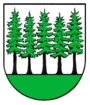
Description of the coat of arms: "In a shield split by gold (yellow) and silver (white) on a red three-mountain three green fir trees, of which the middle one, splitting the shield, extends to the upper edge of the shield."
- Coat of arms of Simonswald and its districts

Simonswald

Old Simons Forest

Obersimonswald
Untersimonswald

Has salmon simons forest

Wildlife expert


Administrative community
There is an agreed administrative community with the city of Waldkirch and the municipality of Gutach .
Town twinning
Since 1997 there has been a partnership between the community of Simonswald and its neighboring communities of Elzach , Gutach im Breisgau, and Waldkirch to form the community of Worthing on the south coast of England.
Economy and Infrastructure
Simonswald is a state-approved resort , which is particularly characterized by its mild climate. The German Clock Route runs through the town.
In addition to tourism, which experienced a strong boom in the 1950s, the main sources of income are mainly small industry (precision and watchmaking ), handicrafts and trade. The farms make their main and sideline income from animal husbandry and forestry . Agriculture is only possible to a limited extent in the lower valley areas. The field designation Rebberg in the lower valley area suggests that wine was also grown here in the past .
Museums
The Jockenhof village museum is located in an old farm in the center of Obersimonswald. The historic building was built around 1640. The collection mainly shows farm equipment that was used in the Simonswäldertal.
The oil mill is a cultural monument from the early 18th century. The house in the style of a pagan house stands between the Wilden Gutach and the Mühlenkanal, about 20 minutes' walk from the center of Simonswald. The oil mill with an undershot water wheel is driven, comprises the actual oil mill with grater stone , oil furnace and pressing device and a Trotte to which belongs a powerful, ten meters long Eichener press beam, which carries the date 1712th Oil was mainly made from locally grown rapeseed , poppy seeds , walnuts or beechnuts . The trot for pressing wine, later pome fruit , had almost the same importance as oil production. After a break of more than forty years, walnut oil has been produced again since 2002. In addition to the oil mill, a functioning grain mill was set up in a side building.
Natural and cultural monuments
The Zweribach waterfalls are a well-known natural spectacle . They are located in the middle of a nature reserve that can only be reached on foot from the Wildgutach district . The machine house of the Zweribachwerk , a pumped storage power plant, is located in Obersimonswald . The Kostgfall Gorge above Haslachsimonswald is well known among climbers . Between Wildgutach and Neukirch , the so-called Balzer Herrgott , which has grown into a tree , is a destination for pilgrimages .
The Simonswälder Mühlenwanderweg leads from the town center over approx. 12 km and 150 meters in altitude past Haslachsimonswald to six historic Black Forest mills .
particularities
The zip code 79271 only applies to the Kandelhof. The community name is emphasized on the final syllable: Simonswáld.
Personalities
- Siegfried Weiß (1933–2013), one of the most successful Black Forest cross-country skiers, nine-time German champion, four-time Olympic participant, lived in Simonswald.
Web links
Individual evidence
- ↑ State Statistical Office Baden-Württemberg - Population by nationality and gender on December 31, 2018 (CSV file) ( help on this ).
- ^ The state of Baden-Württemberg. Official description by district and municipality. Volume IV: District Freiburg Kohlhammer, Stuttgart 1978, ISBN 3-17-007174-2 . Pp. 254-256
- ↑ Altsimonswald - Altgemeinde ~ part of town. leo-bw.de , accessed on June 17, 2019 .
- ^ Federal Statistical Office (ed.): Historical municipality directory for the Federal Republic of Germany. Name, border and key number changes in municipalities, counties and administrative districts from May 27, 1970 to December 31, 1982 . W. Kohlhammer, Stuttgart / Mainz 1983, ISBN 3-17-003263-1 , p. 511 .
- ↑ Stephan Schonefeld becomes the new mayor of Simonswald ( Memento from August 22, 2017 in the Internet Archive ), Badische Zeitung , March 12, 2017.
- ↑ The Simonswald coat of arms , simonswald.de, accessed on March 1, 2020.
- ↑ From farmer's boy to Olympic participant: Siegfried Weiß: One of the most successful Black Forest cross-country skiers is dead ( Memento from January 16, 2016 in the Internet Archive ), Badische Zeitung, March 14, 2013.
- ↑ Honorary member Siegfried Weiß has passed away ( Memento from February 4, 2017 in the Internet Archive ), Skunft Brend eV

Bahlingen am Kaiserstuhl | Biederbach | Denzlingen | Elzach | Emmendingen | Endingen am Kaiserstuhl | Forchheim | Freiamt | Gutach im Breisgau | Herbolzheim | Kenzingen | Malterdingen | Tail | Rheinhausen | Riegel am Kaiserstuhl | Sasbach am Kaiserstuhl | Sexau | Simonswald | Teningen | Vörstetten | Waldkirch | Weisweil | Winden im Elztal | Wyhl am Kaiserstuhl