2009 Pacific Typhoon Season
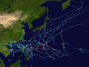
All the storms of the season
|
Formation of the
first storm |
January 3, 2009
|
Dissolution of the
last storm |
December 8, 2009
|
| Strongest storm |
Nida - 905 hPa ( mbar ), 115 kn (215 km / h ) (10 minutes)
|
| Tropical lows |
39 official, 2 unofficial |
| Storms |
22 official, 3 unofficial |
| Typhoons |
13 official, 2 unofficial |
| Super Typhoons (JTWC) |
5 |
| Total number of victims |
> 2300, 240 missing |
| Total damage |
$ 12.219 billion (2009) |
Pacific typhoon seasons
2007 , 2008 , 2009 , 2010 , 2011
|
The 2009 Pacific typhoon season is the cluster of tropical cyclones that occurred in the western Pacific Ocean in 2009 . In contrast to the Atlantic Ocean and its marginal seas, the typhoon season has no official limits, but is identical to the calendar year. Most tropical cyclones, however, form here between May and November. Tropical cyclones that form north of the equator and west of the date line are called typhoons . The storms forming east of the 180th degree of longitude are the subject of the 2009 Pacific hurricane season .
Season forecasts
Forecasts of tropical activity in the 2009 season
|
source
|
date
|
Total
number
|
Named
storms
|
Typhoons
|
|
CityUHK
|
Average (1950–2000)
|
31
|
27
|
17th
|
|
CityUHK
|
April 20, 2009
|
31
|
27
|
18th
|
|
CityUHK
|
June 18, 2009
|
30th
|
27
|
18th
|
|
CWB
|
June 30, 2009
|
-
|
24-27
|
-
|
|
Since the Pacific typhoon season 2000 , the Laboratory for Atmospheric Research at the City University of Hong Kong has been making predictions of the expected number of tropical cyclones, named storms and typhoons during a season. The forecast will be published in April and updated in June. For the 2009 season, CityUHK expects an above-average season. An average season includes 31 tropical cyclones, 27 named storms, and 17 typhoons, based on data from 1950 to 2000, according to university calculations. In the forecast published in April, CityUHK predicts 31 tropical cyclones, 27 named storms and 18 typhoons. The institute also assumes that four tropical cyclones will cross the coast of southern China between May and August . In a normal season, this happens three times between May and August and twice between September and December.
In its June 30 forecast, the Central Weather Bureau of Taiwan assumed that there would be 24-27 tropical storms in the western Pacific, of which three to five would affect Taiwan.
Storms
Tropical Depression Auring
| Tropical Depression ( PAGASA )
|
|
|
| Duration
|
January 3 - January 6
|
| intensity
|
25 kn (45 km / h ) (10 minutes) , 1006 hPa
|
On December 30, 2008, a weather disturbance formed southeast of Manila , Philippines . The system was identified as a tropical disturbance by the JTWC late on January 1st and the JTWC assessed the prospects of developing a tropical cyclone as poor. The system was observed by the JMA as a tropical depression. On the morning of January 3rd, PAGASA gave the name Auring . However, the system could not intensify significantly and was downgraded by PAGASA to a low pressure area on January 5th. The remaining low brought heavy showers across the east of Luzon , Bicol and Visayas .
Heavy rain and flooding forced 38,764 people to seek shelters on Mindanao . One person killed and two more went missing. Traffic was also affected and numerous ferries, intercity buses and trucks had to interrupt their journeys. 305 houses were destroyed and another 610 damaged. The property damage caused by the low pressure system was 23 million PHP - 500.000 USD (2009) - estimated.
Tropical Depression Bising
| Tropical Depression ( PAGASA )
|
|
|
| Duration
|
February 12th - February 13th
|
| intensity
|
25 kn (45 km / h ) (10 minutes)
|
On February 9, a tropical fault formed 150 km north of Palau . The satellite imagery revealed the presence of deep convection on the northern edge of a nontropical trough embedded in an area of moderate vertical wind shear . The next day, the JTWC reported that the disturbance had cleared. However, it regenerated in the early morning of February 12th and reached its greatest intensity in the area of responsibility of Pagasa as Tropical Depression Bising with wind speeds of 45 km / h, which is why PAGASA triggered storm warnings for parts of Visayas and Mindanao . After the low pressure area on Dinagat landed , PAGASA revoked all storm warnings for this system. Ferry traffic between Liloan and Ormoc was temporarily suspended, as was traffic to and from Cebu . The residual low produced heavy rain showers in areas in southern Luzon , in the Bicol region and in Visayas on February 14 before it dissolved. On the island of Cebu, the rain caused landslides that blocked a main road.
Tropical Depression Crising
| Tropical Depression ( PAGASA )
|
|
|
| Duration
|
April 30th - May 1st
|
| intensity
|
30 kn (55 km / h ) (10 minutes)
|
In the early morning of April 29th, the weather strengthened 430 km southwest of Manila. Satellite images showed a cylindrical circulation close to the ground with interrupted convection bands on its southwestern edge. The system was located in a zone of low vertical wind shear. During the course of the day, the system steadily consolidated itself under the influence of an anticyclone . The next morning, PAGASA assigned the system the local name Crising and reported that Crising was reaching wind speeds of 55 km / h. A few hours later, storm warnings were issued for parts of western Luzon as the system slowly moved west in the South China Sea. In the course of the day, the crisis and the disturbance of the weather, which later developed into Typhoon Kujira, influenced each other. As a result, Crising's center of circulation was poorly defined. The system could not regenerate and on May 2nd, PAGASA issued the last warnings for the Philippines.
Heavy rainfall through the outer rain bands Crisings led to floods in the west of the Philippines, which affected around 2500 residents. The floods were worst in Lucena City , where ten towns were cut off. Areas on Bucon and Inalmasinan were flooded, causing significant crop damage. Several animals drowned in the region, roads were washed away by flood water or made impassable by landslides. In Mercedes.
Typhoon Kujira (Dante)
| Typhoon ( JMA )
|
| Category 4 typhoon
|
|
|
| Duration
|
May 1st - May 7th
|
| intensity
|
85 kn (155 km / h ) (10 minutes) , 940 hPa
|
In the early hours of April 26, a weather disturbance formed near Baler, Aurora that was originally the tail end of a cold front that passed through northern Luzon . The JTWC initially assessed the possibility that this disruption would develop into a tropical cyclone within 24 hours as good, on April 28, Pearl Harbor declared the system to be disintegrating, reflecting the interactions between Tropical Depression Crising and that of the JMA declined system classified as Tropical Depression 03. The system moved southwest for a few days and passed over Albay . On May 1st, the system reorganized itself above water and in the afternoon was classified by PAGASA as the Dante Tropical Low Pressure Area. Storm warning signal number one was set in the provinces of Camarines Norte , Camarines Sur , Albay, Sorsogon , Catanduanes , Masbate , Burias and for the south of Quezon. PAGASA reported that Dante was moving across land near Sorsogon in the Bicol region. In the early morning of May 2, Dante remained almost stationary and was classified by the JMA as a full-fledged low pressure area during the day. Early the next day the system reached the strength of a tropical storm and was named Kujira. The storm continued to intensify and turned into a severe tropical storm by the afternoon of May 3. The JMA upgraded Kujira to a typhoon on the morning of May 4, which continued to intensify rapidly, evolving from a typhoon equivalent to Category 2 on the Saffir-Simpson Hurricane Scale to a Category 4 typhoon within 24 hours. On May 6, the JTWC reported the beginning of the transition to an extra-tropical cyclone , as the circulation center near the ground had almost completely detached from the convection and the vertical wind shear increased and the water surface temperature decreased. The JMA later downgraded Kujira to a severe tropical storm as strong wind shear took a toll on the system. In the morning of May 7th, the JMA downgraded Kujira to a tropical storm; in the course of the day Kujira became completely extra-tropical.
In the Philippines, Kujira caused around 626 million pesos of damage to crops and livestock, and another 102 million pesos to irrigation systems for agriculture. The national crisis team declared a total of 28 people dead and one missing on May 12th. The storm affected 383,457 people in 609 Barangay within 60 municipalities and four cities in five provinces of Region V. Property damage was reported at 1.228 billion Philippine pesos, of which 626 million was damage to agriculture and around 530 million was damage to infrastructure and houses are omitted. A total of 138 were completely and 2249 partially destroyed.
May 1st Tropical Depression
| Tropical Depression ( JMA )
|
|
|
| Duration
|
May 1st - May 7th
|
| intensity
|
30 kn (55 km / h ) (10 minutes) , 1004 hPa
|
On April 20, a weather disturbance formed southeast of Yap , which slowly moved to the northwest over the following days. On April 27, the JTWC and JMA agreed that the system would disintegrate, but the next day it regenerated and began moving southeast. By early May 2nd, the system had intensified into a negligible tropical depression. Around noon of the day, the system became weaker, on the one hand due to strong wind shear and on the other hand due to the interactions with the developing Typhoon Kujira. The JMA continued its observations until May 4th. Then only a low-level circulation could be seen, which completely dissolved by May 7th.
Typhoon Chan-hom (Emong)
| Typhoon ( JMA )
|
| Category 2 typhoon
|
|
|
| Duration
|
May 1st - May 13th
|
| intensity
|
65 kn (120 km / h ) (10 minutes) , 975 hPa
|
On May 1, an area of convective cloud combined with a weather disturbance southeast of Nha Trang , Vietnam and with residual Crisings, forming a strong new weather system. Due to slight vertical wind shear and an altitude anticyclone east of the system, the system intensified and was classified as a small tropical depression by the JMA. The system first migrated to the southeast and east by early morning on May 3. The system intensified further and on that day was upgraded to a tropical storm by the JMA and given the name Chan-hom . On May 4th, Chan-hom intensified into a severe tropical storm. On May 6th, the cyclone moved to PAGASA's area of responsibility and was given the local name Emong. After further intensification, the storm was classified as a typhoon by the RSMC in Tokyo. On May 7th, PAGASA reported that the typhoon had passed over the northern tip of Bolinao .
After crossing Pangasinan, it affected La Union , Ilocos Sur , Benguet , Nueva Vizcaya , Ifugao , Kalinga and Isabela. Pangasinan (with 150mm of rainfall from Emong) and La Union were the hardest hit provinces. Weather stations in the provinces in central Luzon, Ilocos , Cordillera Administrative Region and Cagayan Valley as well as in Metro Manila and parts of southern Luzon reported precipitation of more than 100 mm within 24 hours on May 7th. However, the rain from the typhoon lasted from May 6th to May 8th. The national disaster center reported on May 13th that the typhoon killed 50 people and injured 47, the number of missing persons was 13 at the time. Property damage was given as 690 million Philippine pesos. 204,000 people were affected by the typhoon. Of the total of 23,280 damaged houses, 6080 were completely destroyed and 17,200 partially. The typhoon also triggered 11 landslides in Zambales and Cagayan. On May 8th, Chan-hom was downgraded to a tropical storm and during the day to a tropical depression. The JMA issued the final warning on the morning of May 9th, but continued to monitor the system until the circulation finally ceased on May 13th, when the system was carried away by the jet stream in a northwesterly direction.
Severe tropical storm Linfa
| Severe Tropical Storm ( JMA )
|
| Category 1 typhoon
|
|
|
| Duration
|
June 14th - June 23rd
|
| intensity
|
60 kn (110 km / h ) (10 minutes) , 975 hPa
|
In the early morning of June 10th, the JTWC reported the formation of a weather disturbance about 140 km southeast of Palau . The fault had an elongated center of circulation, the deep convection of which developed in the southwest quadrant. A tropical wave provided the system with good outflow, thereby increasing the deep convection in the center of the circulation, which was now in a zone of moderate wind shear. In the days that followed, the fault developed steadily and was classified by the JMA as the fifth tropical depression of the season in the early hours of June 14th. A few hours later, the JTWC triggered a Tropical Cyclone Formation Alert (TCWA) when the system was about 520 km southeast of Manila. However, the JMA published its last warning about the system during the course of the day and downgraded it to a nontropical low pressure area, while the JTWC revoked the TCFA because the convection near the ground-level circulation center was significantly weaker. A QuikSCAT analysis showed that at the time the circulation near the ground was embedded in the monsoon channel, whereas observations of the higher air layers showed that despite the presence of very dry air, the environment remained favorable for cyclone development. On June 15 and 16, the remaining low brought heavy rains to the various islands of Luzon as it passed across the Philippines. When it entered the South China Sea, a new TCFA was triggered by the JTWC late on June 16. The next morning, the JMA reported that the disturbance was intensifying into a second tropical depression. The system intensified on June 18 with Tropical Storm Linfa, dubbed 03W by the JTWC , while it was about 705 km south-southwest of Kaohsiung, Taiwan.
As the trough continued to develop, the JTWC upgraded it to a tropical storm on the evening of June 17. The next morning, the JMA named the storm Linfa. During the day, limited polar discharge prevented Linfa from increasing any further. On June 19, Linfa intensified further into a severe tropical storm and one eye formed. Due to the effects of a nearby low altitude, the outflow improved and Linfa continued to intensify, so that the next day the JTWC upgraded the storm to a typhoon with a one-minute top speed of 140 km / h. Later that day, the convection in the center subsided and the eye disappeared. Wind shear at high altitudes prevented the typhoon from strengthening again. As Linfa approached the mainland, exposure to the land resulted in the gradation to a tropical storm on June 21. In the afternoon, the storm hit the southern Chinese province of Fujian. The convection quickly dissolved as the storm center moved away from the coastline, so that on July 22nd Linfa was downgraded to a tropical depression by the JTCW and JMA. The system broke up just offshore.
7 people were killed in the storm and property damage was $ 110 million. Areas affected were China, Taiwan, Hong Kong and the Philippines. An oil tanker ran aground south of Taiwan due to high waves. Two people were killed by falling trees in Taiwan. There have been power outages in Chiangchun and other areas of China and Taiwan. Agriculture in Taiwan suffered $ 12.1 million in damage. Torrential rains caused severe flooding in China. There were landslides and one person was killed. The floods destroyed 100 houses and 10,000 more houses were flooded, as well as 32,000 hectares of farmland in Fujian Province. After 413.7 mm of rain fell within 9 hours, the subsequent floods killed another five people in Meizhou, Guangdong Province. In the city, 362 houses were destroyed and the infrastructure was badly damaged. About 20 million people were affected by the storm.
Tropical storm feria
| Tropical Storm ( JMA )
|
| Tropical storm
|
|
|
| Duration
|
June 22nd - June 26th
|
| intensity
|
40 kn (75 km / h ) (10 minutes) , 994 hPa
|
On June 16, a weather disturbance formed about 170 km northeast of Palau, which developed over the next few days, but did not have a well-defined near-surface circulation center. In the early hours of June 20th the disturbance suddenly began to intensify and the center of circulation also consolidated. The fault was below a slight vertical wind shear. At 6:00 a.m. UTC on June 22, the JMA classified the system as a tropical depression. The convection had started to organize and the analyzes of the upper air layers showed a circulation center west of Guam . The JTWC ran the system as 04W while PAGASA gave it the local name Feria on June 23rd .
At 5:00 p.m. local time (9:00 a.m. UTC), the storm reached Hernani in Eastern Samar by land and five hours later it reached Masbate again. When Nangka passed over Mindoro after his third landfall at 4:30 a.m. near Calapan City on June 24th, wind speeds dropped rapidly. It took Nagka eight hours to cross Mindoro and has been classified as a tropical depression by PAGASA; However, the JMA and JTWC retained the classification of Nangka as a tropical storm. Early on June 25th, Nangka moved across the South China Sea, so PAGASA issued the final warning that the storm was beyond their control. In the evening, both the RSMC Tokyo and the JTWC Nangka were downgraded to a tropical depression because the circulation center near the ground began to disintegrate. The system came over land for the fourth time at noon on June 26, now in Guangdong Province in the People's Republic of China, and it grazed northern areas of Hong Kong . A few hours later, JMA and JTWC issued the final warnings on Nangka. The remaining low of the storm dissolved completely on June 27th.
Ferry traffic in Eastern Samar has ceased. Unusually strong thunderstorms developed at the foothills of the storm in other areas of the Philippines. Large hailstones fell in San Pascual, Bauan and Batangas City . Heavy rain in connection with Nangka flooded several regions, sometimes the water was waist high. Later reports confirmed that a tornado destroyed 23 homes in Barangay. At least one person was killed as a result of the storm in Cebu. Nangka has left at least 500 people in the Philippines homeless. 7,000 travelers were stuck in Cavite because the port was closed due to heavy rain and waves. The storm surge reached a height of around 1.2 m above normal here.
At least six people were killed by Nangka in the Philippines, and eleven more were missing on June 24, according to official information. The property damage was estimated by the National Disaster Management Commission at 2.8 million Philippine Pesos (around 54,000 USD).
Tropical storm Soudelor (Gorio)
| Tropical Storm ( JMA )
|
| Tropical storm
|
|
|
| Duration
|
July 9th - July 13th
|
| intensity
|
35 kn (65 km / h ) (10 minutes) , 992 hPa
|
On July 7, the JTWC reported that a weather disturbance had formed 900 km northwest of Yap. Deep convection embedded in a wide and weak circulation with a poorly developed center that began to enlarge due to a tropical depression east of the system. The system developed over the next few days until, on July 9, the JTWC triggered a Tropical Cyclon Formation Alert. PAGASA named the system the Tropical Depression Gorio. The JTWC later published warnings referring to the system as 05W, while the JMA hesitated to publish warnings until the next day. On July 10th, PAGASA issued its final warning on Gorio. While it withdrew from their area of responsibility, it was hindered by an unfavorable high-altitude current. The depression gradually intensified and both the JTWC and JMA reported intensification to a tropical storm by the next morning. The storm was called Soudelor by the JMA. Later that day, the JTWC reported that Soudelor had weakened to a low pressure area. It was upgraded to a tropical storm again as it approached Hainan Province. On July 11, the storm was downgraded to a tropical depression by the JTWC and JMA. The JTWC issued its final warning that afternoon. The JMA published the last report on July 13th.
Huaning Tropical Depression
| Tropical Depression ( JMA )
|
| Tropical depression
|
|
|
| Duration
|
July 11th - July 14th
|
| intensity
|
30 kn (55 km / h ) (10 minutes) , 1000 hPa
|
On July 10, the JTWC reported that a weather disturbance had formed approximately 1065 km east of Manila. The convection was associated with a well-developed circulation and was under an anticyclone. The system began by building a discharge into a trough northeast of the system and was classified as a tropical depression by the JMA on July 11th, officially the eighth of the season. The system continued to develop, but did not achieve official tropical storm status, although PAGASA ran the system as a tropical storm on July 13, giving it the local name of Huaning. The low pressure area moved in a north-westerly direction and reached Chungyang in Taiwan overland. There it weakened, so that the JMA and the JTWC issued their last warnings about the system on July 14th.
Typhoon Molave (Isang)
| Typhoon ( JMA )
|
| Category 1 typhoon
|
|
|
| Duration
|
July 14th - July 19th
|
| intensity
|
65 kn (120 km / h ) (10 minutes) , 975 hPa
|
Late on July 10, there was a weather disturbance about 280 km southeast of Yap . The convection was embedded in a poorly developed circulation center close to the ground and was covered by minimal wind shear. The system continued to develop over the course of the next day. However, on July 12, the JTWC found that the disorder had resolved because Huaning blocked the outflow from the system, but triggered a TCFA again on July 13. The JMA classified the system as a tropical depression on July 14, and PAGASA assigned the system the local name Isang . The low pressure area continued to develop and intensified into a tropical storm on July 15th. On July 17, the JMA upgraded the storm to a severe tropical storm. On the morning of July 18, Molave intensified into a typhoon that swiftly moved into the South China Sea. On July 19, at 5:00 p.m. UTC (1:00 a.m. HKT), the storm moved over land. In the afternoon of the day, the JTWC and JMA issued the final warnings about the system, which was rapidly weakening into a tropical depression over mainland China. The effects of Typhoon Molave killed at least four people.
Tropical storm Goni (Jolina)
| Tropical Storm ( JMA )
|
| Tropical storm
|
|
|
| Duration
|
July 30th - August 9th
|
| intensity
|
40 kn (75 km / h ) (10 minutes) , 988 hPa
|
Late on July 25, the JTWC reported the formation of convection that was forming around the center of a low-pressure area in the monsoon channel about 815 km northeast of Guam . An anti-cyclone and a tropical trough in the upper troposphere provided for outflow. The system developed steadily over the next few days, but on July 28th the system was declared dissolved because the circulation center near the ground no longer appeared to be particularly well organized and under the influence of strong vertical wind shear.
On July 30th, about 630 km from Guam, the disturbance reorganized with an elongated center of circulation that featured multiple eddies. After further intensification, PAGASA declared that a tropical disturbance had formed and assigned the name Jolina to the system, which was only valid for the Philippines. The depression continued to intensify and was classified as a tropical depression by the JMA on July 31st. After the deep convection increased and consolidated around a circulation center, the JTWC issued a Tropical Cyclone Formation Alert on August 1st. On the morning of the same day, however, Jolina moved overland near Casiguran in the province of Aurora and only reached the South China Sea during the course of the day . On August 2nd, PAGASA stopped the warnings because Jolina had left the area of responsibility of the Philippine Meteorological Authority and moved to China. Later that day, the JTWC used infrared footage to upgrade the system to a tropical storm, the eighth on the JTWC count. The JMA only upgraded the system to a tropical storm one day later and gave it the name Goni . With the landfall in Macau , the system moved overland for the second time on August 4 at 5:00 p.m. On August 7, the JTWC found that the remaining depth of Tropical Storm Goni had reached the Gulf of Tonkin . According to the JTWC criteria, the system intensified again to a tropical storm and moved south, but lost its intensity again just a few hours later, so that the JTWC issued its last warning.
In the Philippines, at least 12 people died as a result of the tropical storm Goni, and 221,412 people in 281 villages in 13 provinces were directly affected by the effects of the storm. Property damage was estimated at Php 131.3 million Philippine Pesos, of which 24.6 million was in agriculture and 106.7 million in infrastructure. In China, the storm killed five people. Authorities had to evacuate 92,000 people in Hainan Province. 575 houses were destroyed and 2,311 damaged. More than 68,000 hectares of arable land were flooded.
Typhoon Morakot (Kiko)
| Typhoon ( JMA )
|
| Category 1 typhoon
|
|
|
| Duration
|
August 2nd - August 11th
|
| intensity
|
75 kn (140 km / h ) (10 minutes) , 945 hPa
|
On August 2, the JMA determined that the eleventh tropical low pressure area of the season had formed in a monsoon trough about 1000 km east of the Philippines. The low pressure area remained weak and during the day the JMA initially downgraded it to an area with convective activity, a few hours later the JMA found that the depression had regenerated and that the deep convection flared up on the western side of a partially exposed circulation center. On August 3rd, the system came under the responsibility of PAGASA, which assigned the name Kiko . A few hours later, the Regional Specialized Meteorological Center upgraded the system to a tropical storm and renamed it with the internationally recognized name Morakot . The JTWC listed Morakot as 09W .
Tropical storm Etau
| Tropical Storm ( JMA )
|
| Tropical storm
|
|
|
| Duration
|
August 8th - August 14th
|
| intensity
|
40 kn (75 km / h ) (10 minutes) , 992 hPa
|
On August 6, an area of convective clouds was in the monsoon trough about 1,000 km southwest of Iwo To , Japan. Satellite images showed a TUTT northeast of the system, which was also under the influence of strong vertical wind shear and was in a favorable environment. Late on August 7th, the JTWC triggered a Tropical Cyclone Forming Alert and the JMA classified the system as a tropical depression on August 8th. The system intensified further into a tropical storm and was named Etau .
In the follow-up analysis, the JMA classified Etau as a tropical storm with ten-minute wind speeds of 75 km / h.
Tropical Depression Maka
| Tropical Depression ( JMA )
|
| Tropical storm
|
|
|
| Duration
|
August 13 (from Central Pacific) - August 17
|
| intensity
|
30 kn (55 km / h ) (10 minutes) , 1006 hPa
|
On August 13, the residual low of Tropical Storm Maka crossed the international date line and reached the Western Pacific; the JMA immediately classified the system as a tropical depression. During the course of the day, the JTWC found that the system was about 1,425 km southeast of Wake and that convection was forming in the northern quadrant of a long, ground-level circulation center. The system was in an area of light to moderate wind shear and the discharge into an elevated trough was well developed. The next day the JTWC saw the possibility that the formation of a tropical storm was possible at any time because the circulation center had evolved Later that day, the JTWC re-upgraded the disturbance to Tropical Depression 01C (Maka). and the next day the JTWC temporarily upgraded the depression to a tropical storm. The system, however, failed to evolve and lost power as it slowly drifted further west. On August 17th, the JMA found that the system had disbanded.
Typhoon Vamco
| Typhoon ( JMA )
|
| Category 4 typhoon
|
|
|
| Duration
|
August 16 - August 25
|
| intensity
|
90 kn (165 km / h ) (10 minutes) , 945 hPa
|
On August 14, an area with convective monsoon clouds formed about 750 km northeast of Pohnpei . Satellite images showed that convection bands were arranged between the north-east and south-west around the circulation center near the ground. In addition, the system was subject to only slight wind shear and in the northeast quadrant there is a slight poleward outflow into a tropical trough in the upper troposphere. On the afternoon of August 16, the JMA classified the system as a tropical depression and a day later as Tropical Storm Vamco. On August 18, Vamco intensified into a severe tropical storm and in the early hours of August 19, RSMC upgraded Vamco to a minimal typhoon. Six hours later, a tiny eye was visible on satellite imagery , and Vamco had intensified into a typhoon that was equivalent to Category 2 on the Saffir-Simpson Hurricane Scale. Early on August 22nd, Vamco peaked as a typhoon equivalent to a Category 4 hurricane. Around August 25th, Vamco approached the most south-westerly islands of the Aleutian Islands and quickly lost its tropical characteristics. The storm developed features of a front system and the eye quickly became less pronounced, so that the JTWC and a few hours later the JMA issued their final warnings about the weakening storm. Vamco stayed away from land and therefore no damage was reported.
Tropical Depression August 20th
| Tropical Depression ( JMA )
|
|
|
| Duration
|
August 20 - August 21
|
| intensity
|
30 kn (55 km / h ) (10 minutes) , 1002 hPa
|
Early on August 20, the JMA reported that a tropical depression had reported about 720 km southeast of Okinawa , Japan . The JTWC found during the day that the system had a broad, low-convection center of circulation close to the ground, and that the conditions for further development were favorable because the temperature of the water surface was high and the vertical wind shear was low. However, the next day the JMA issued the final warning about the system that had downgraded it to a low pressure area. It finally broke up early on August 22nd.
Tropical Depression August 25th
| Tropical Depression ( JMA )
|
|
|
| Duration
|
August 25th - August 26th
|
| intensity
|
30 kn (55 km / h ) (10 minutes) , 1004 hPa
|
In the early hours of August 25th, the JTWC noticed a convection center about 1,000 km southeast of Okinawa, Japan. The convection moved over a wide and poorly defined circulation center close to the ground, the vertical wind shear was low. A high trough approached the system from the northwest and obstructed the outflow; it also brought cooler, drier air near the disturbance. During the day, the JMA classified the system as a tropical depression. The JTWC reported early the next morning that the depression had resolved. The JMA initially continued the storm warnings and only issued the last warning about the system later on August 26th.
Heavy Tropical Storm Krovanh
| Severe Tropical Storm ( JMA )
|
| Category 1 typhoon
|
|
|
| Duration
|
August 28th - September 1st
|
| intensity
|
60 kn (110 km / h ) (10 minutes) , 975 hPa
|
Tropical Depression 02C
| Tropical Depression ( JMA )
|
| Tropical depression
|
|
|
| Duration
|
August 29th - September 2nd
|
| intensity
|
30 kn (55 km / h ) (10 minutes) , 1004 hPa
|
Severe Tropical Storm Dujuan (Labuyo)
| Severe Tropical Storm ( JMA )
|
| Tropical storm
|
|
|
| Duration
|
September 1st - September 10th
|
| intensity
|
50 kn (95 km / h ) (10 minutes) , 980 hPa
|
Tropical Depression September 3rd
| Tropical Depression ( JMA )
|
|
|
| Duration
|
September 3 - September 9
|
| intensity
|
25 kn (45 km / h ) (10 minutes) , 1000 hPa
|
Tropical Storm Mujigae (Maring)
| Tropical Storm ( JMA )
|
| Tropical depression
|
|
|
| Duration
|
September 8th - September 12th
|
| intensity
|
40 kn (75 km / h ) (10 minutes) , 994 hPa
|
Typhoon Koppu (Nando)
| Typhoon ( JMA )
|
| Category 1 typhoon
|
|
|
| Duration
|
September 11th - September 16th
|
| intensity
|
65 kn (120 km / h ) (10 minutes) , 975 hPa
|
Typhoon Choi-wan
| Typhoon ( JMA )
|
| Category 5 super typhoon
|
|
|
| Duration
|
September 11th - September 21st
|
| intensity
|
105 kn (195 km / h ) (10 minutes) , 915 hPa
|
Typhoon Choi-wan formed in the early morning of September 11, 2009 as a weak tropical disturbance about 1,100 km east of Guam. On that day, the fault developed rapidly and was classified as a tropical depression by both the JMA and the JTWC the next day. The intensification continued and on September 12th the JMA named the system, which had meanwhile grown into a tropical storm, the name Choi-wan . During September 13th, the rapid intensification slowed and Choi-wan barely reached the strength of a severe tropical storm before the rapid intensification resumed the next day, so that Choi-wan was classified as a typhoon. During the day, the typhoon gained so much strength that it corresponded to Category 4 on the Saffir-Simpson Hurricane Scale. Choi-wan then intensified further during September 15, according to the JMA, the ten-minute peak wind speed was 195 km / h, the Joint Typhoon Warning Center reported the peak of the Category 5 typhoon with one-minute wind speeds of 260 km / h.
Due to an excellent poleward outflow and high water surface temperatures, Choi-wan remained at its peak strength until the early morning of September 17, when the deep convection in the northwest quadrant began to subside because the tropical high trough (TUTT) in a northwest direction no longer worked for you provided good discharge. Choi-wan was therefore downgraded by the JTWC while the typhoon underwent cyclical eyewall regeneration . With one-minute peak winds of 150 km / h, Choi-wan reached a secondary peak on September 18. On September 19, Choi-wan rapidly lost its intensity as the typhoon entered an unfavorable environment where much stronger wind shear began to erode the typhoon's deep convection. As a result of this, and due to the fact that drier air was now being drawn into the circulation center, the JTWC decided to downgrade Choi-wan to an extra-tropical cyclone and issued the final warning about the storm early the next day. The JMA follows this step during the day.
Although the Choi-wan intensity was very high as it passed through the Northern Mariana Islands , no personal injuries were reported. It was later determined by the US Navy that the entire island of Alamagan was uninhabitable because, with the exception of a laboratory and research building, all structures had been completely destroyed and most of the trees on the island had not withstood the force of the typhoon. As a result, it was decided that all residents of Alamagan and Agrihan were brought to Saipan .
September 23rd Tropical Depression
| Tropical Depression ( JMA )
|
|
|
| Duration
|
September 23rd - September 26th
|
| intensity
|
25 kn (45 km / h ) (10 minutes) , 1006 hPa
|
Typhoon Ketsana (Ondoy)
| Typhoon ( JMA )
|
| Category 2 typhoon
|
|
|
| Duration
|
September 23rd - September 30th
|
| intensity
|
80 kn (150 km / h ) (10 minutes) , 960 hPa
|
Tropical Depression 18W
| Tropical Depression ( JMA )
|
| Tropical depression
|
|
|
| Duration
|
September 27th - September 30th
|
| intensity
|
30 kn (55 km / h ) (10 minutes) , 1000 hPa
|
On September 26th, an area of convective clouds formed about 200 km northeast of Fananu . Satellite imagery showed that a circulation center close to the ground was partially exposed, and a TUTT provided discharge to the northwest. The morning of the next day, the system organized itself better due to a favorable environment, so the JMA classified the system as a tropical depression. On September 28, the JTWC determined the intensification into a tropical storm according to the criteria of the JTWC, but the JMA ruled out an intensification on September 29 because the system came under the influence of the intensifying Typhoon Parma on the one hand and its tropical properties on the other lost. Around noon on September 30th, the system moved over Andersen Air Force Base as a weakening tropical depression. Accordingly, on the evening of September 30th, the JTWC issued the final warning on 18W and the JMA declared that the system had disbanded. The remains were then absorbed by Typhoon Parma, so that it gained even more strength.
Typhoon Parma (Pepeng)
| Typhoon ( JMA )
|
| Category 4 super typhoon
|
|
|
| Duration
|
September 27th - October 14th
|
| intensity
|
100 kn (185 km / h ) (10 minutes) , 930 hPa
|

The cyclones of Parma and Melor
Typhoon Melor (Quedan)
| Typhoon ( JMA )
|
| Category 5 super typhoon
|
|
|
| Duration
|
September 28th - October 11th
|
| intensity
|
110 kn (205 km / h ) (10 minutes) , 910 hPa
|
On September 28, a convective clouded area formed about 370 km northeast of Pohnpei . Satellite images showed that a circulation center close to the ground had begun to form. On the evening of September 28, a tropical high-altitude trough ensured good outflow and the vertical wind shear was favorable, so that the JTWC triggered a Tropical Cyclone Formation Alert. Both JMA and JTWC classified the system as a tropical depression on September 29th. In the early hours of September 30th, the JMA discovered that the system had intensified into a tropical storm and gave it the international name of Melor . By October 1, Melor intensified first into a severe tropical storm and then into a typhoon. The intensification continued rapidly, and that afternoon the JTWC reported that Melor had reached strength equivalent to Category 3 on the Saffir-Simpson Hurricane Scale. The typhoon continued to intensify and migrated towards northeast Luzon . In the early morning of October 2, it reached category 4, where it initially remained, only to strengthen again a day later until, according to the JTWC, on October 4 it had intensified to a category 5 super typhoon. The JMA determined the lowest air pressure in the center of the typhoon at 910 hPa and the continuous ten-minute wind speeds at 205 km / h. On October 5th, PAGASA assigned the local Quedan to the typhoon as it was approaching the Philippines. However, because Typhoon Parma blocked the way to the west, the typhoon turned north, and by noon on October 8th, Melor moved overland in Japan. After landfall, the JMA Melor downgraded to a severe tropical storm, while the JTWC already classified the system as an extra-tropical storm.
The remnants of Typhoon Melor were absorbed into a newly created depression late on October 9th . This crossed the Pacific Ocean and reached the coast of California . The system resulted in the San Francisco Bay Area to heavy rain and wind gusts of 124 km / h on fishing Iceland . Insurance companies put the damage in California at $ 1.5 billion.
Tropical storm Nepartak
| Tropical Storm ( JMA )
|
| Tropical storm
|
|
|
| Duration
|
October 8th - October 13th
|
| intensity
|
45 kn (85 km / h ) (10 minutes) , 992 hPa
|
On October 6, in conjunction with a monsoon trough, an area of convective clouds formed about 500 km southwest of Saipan . Satellite images showed a consolidating near-surface circulation center with convection bands and deep convection in the northern semicircle. On the morning of October 8th, the system began to move north-northwest and, due to favorable conditions, the center of circulation was quickly better defined, so that the JMA classified the system as a tropical depression. On October 9, the JMA upgraded the system to a tropical storm and named it Nepartak . In the hours that followed, the storm intensified to its peak intensity with ten-minute wind speeds of 85 km / h. On October 14th, however, the storm broke up because it was torn in two by the polar jet stream.
Typhoon Lupit (Ramil)
| Typhoon ( JMA )
|
| Category 5 super typhoon
|
|
|
| Duration
|
October 13th - October 27th
|
| intensity
|
95 kn (175 km / h ) (10 minutes) , 930 hPa
|
Early on October 13th, the JTWC reported that a convection area had formed about 380 nautical miles northwest of Kwajalein. The convection was still poorly organized, but began to consolidate around an extensive circulation close to the ground. The vertical wind shear was low and the water surface temperature was beneficial for further development. The disturbance developed rapidly so that the JMA began issuing storm warnings on the morning of October 14, and the JTWC assumed that a weak tropical storm had already formed. The system continued to migrate in a west-northwest direction for the next few days. It was upgraded to a tropical storm by the JMA on October 15 and was named Lupit . On October 16, the JTWC found that Lupit had intensified into a typhoon; The JMA did not classify Lupite as a typhoon until a few hours later, around the same time that PAGASA assigned the typhoon the local name Ramil , as the typhoon had come under the responsibility of the Philippine meteorologists. For the next two days, the typhoon initially swung north and then moved northeast before returning to its original west-northwest direction. During this time, due to favorable conditions and high water temperatures, lupite intensified further and, after rapid intensification, reached an intensity equivalent to category 3 on the Saffir-Simpson hurricane scale on October 17 and even category 4 on the morning of October 18 reached its greatest strength with sustained wind speeds of 95 knots . On October 20, the strength of the typhoon declined rapidly. Although the typhoon threatened Luzon again and it was forecast for a time that the typhoon would touch the far north of the island, the forward speed of the cyclone decreased. Dry air and unfavorable conditions had further aggravated the storm, so that it was downgraded to a severe tropical by the JMA on October 24th. approached the northeastern tip of Luzon, but was then caught by a steering current that quickly carried the storm away in a northeastern direction. JTWC and PAGASA issued their final warnings because Lupit's transition to an extra-tropical storm was beginning; However, the JMA continues its warnings until October 27th.
Tropical Depression October 16
| Tropical Depression ( JMA )
|
|
|
| Duration
|
October 16 - October 20
|
| intensity
|
25 kn (45 km / h ) (10 minutes) , 1002 hPa
|
Late on October 15, the JTWC reported the formation of a low pressure area about 780 km southeast of Hue, Vietnam, which soon created convection and a low-level circulation center. The system was moving into a zone of favorable conditions for further development, with low vertical wind shear and warm water temperatures. The next morning, the JMA classified the system as tropical. The circulation center was exposed due to strong vertical wind shear at the time. However, the low pressure area remained weak and could not develop further. It broke up on October 20th.
Typhoon Mirinae (Santi)
| Typhoon ( JMA )
|
| Category 2 typhoon
|
|
|
| Duration
|
October 25th - November 2nd
|
| intensity
|
80 kn (150 km / h ) (10 minutes) , 955 hPa
|
Tropical Depression 24W (Tino)
| Tropical Depression ( JMA )
|
| Tropical depression
|
|
|
| Duration
|
November 1st - November 3rd
|
| intensity
|
30 kn (55 km / h ) (10 minutes) , 1006 hPa
|
Tropical Depression 25W
| Tropical Depression ( JMA )
|
| Tropical storm
|
|
|
| Duration
|
November 7th - November 10th
|
| intensity
|
30 kn (55 km / h ) (10 minutes) , 1000 hPa
|
In the morning of November 3, the JTWC reported that there was a convection area in the Mohnsunnrinne about 440 nautical miles southeast of Pohnpei. The convection was poorly organized and was surrounded by a weak, rolled-out circulation of medium height. However, the environmental conditions were not favorable to further development as there was moderate vertical wind shear in the area. Over the next few days, the fault slowly developed a low-level circulation center and both JMA and JTWC classified the system as a tropical depression on November 7th. The system slowly moved eastward. It was upgraded to a tropical storm for a short time by the JTWC but was unable to maintain that intensity. The JMA did not classify the system as a tropical storm. Without having endangered the country, the system disintegrated on November 10th.
Tropical Depression 27W (Urduja)
| Tropical Depression ( JMA )
|
| Tropical depression
|
|
|
| Duration
|
November 21st - November 25th
|
| intensity
|
30 kn (55 km / h ) (10 minutes) , 1002 hPa
|
Typhoon Nida (Vinta)
| Typhoon ( JMA )
|
| Category 5 super typhoon
|
|
|
| Duration
|
November 21st - December 4th
|
| intensity
|
115 kn (215 km / h ) (10 minutes) , 905 hPa
|
Tropical Depression November 24th
| Tropical Depression ( JMA )
|
|
|
| Duration
|
November 24th - November 26th
|
| intensity
|
30 kn (55 km / h ) (10 minutes) , 1006 hPa
|
Tropical Depression 28W
| Tropical Depression ( JMA )
|
| Tropical storm
|
|
|
| Duration
|
December 2nd - December 5th
|
| intensity
|
25 kn (45 km / h ) (10 minutes) , 1000 hPa
|
Tropical Depression of December 7th
| Tropical Depression ( JMA )
|
|
|
| Duration
|
December 7th - December 8th
|
| intensity
|
25 kn (45 km / h ) (10 minutes) , 1008 hPa
|
Late on December 7th, the JTWC reported that about 965 km southeast of Manila a convection area had formed around a rapidly developing ground-level circulation center. The near-ground circulation center had rapidly formed from the southwestern extension of a shear front. The JTWC assumed that the formation of a tropical system took place immediately, the Japan Meteorological Agency reported the formation of a tropical low pressure area only one day later. The JMA issued the final warning about the system a few hours later and the JTWC revoked the TCFA because the system had moved across Mindanao and disintegrated over land.
Storm names
Tropical cyclones in the western North Pacific are named by the RSMC Tokyo-Typhoon Center of the Japan Meteorological Agency . The names come from the following list. This is used continuously, so there are no annually changing lists of names like in the eastern North Pacific or the Atlantic. The names were proposed by 13 members of the ESCAP / WMO Typhoon Committee . Each of these members - with the exception of Singapore - submitted ten proposed names, which are used in alphabetical order of the members' English names. The first name used in the 2009 season was Kujira . Names that have not been assigned are shown in gray .
| ESCAP / WMO member state |
Names
|
| Cambodia |
Damrey |
Kong-rey |
Nakri |
Krovanh (0911) |
Sarika
|
| China |
Haikui |
Yutu |
Fengshen |
Dujuan (0912) |
Haima
|
| DPR Korea |
Kirogi |
Toraji |
Kalmaegi |
Mujigae (0913) |
Meari
|
| Hong Kong |
Kai-tak |
Man-yi |
Fung-wong |
Choi-wan (0914) |
Ma-on
|
| Japan |
Tembin |
Usagi |
Kammuri |
Koppu (0915) |
Tokage
|
| Laos |
Bolaven |
Pabuk |
Phanfone |
Ketsana (0916) |
Cams
|
| Macau |
Sanba |
Wutip |
Vongfong |
Parma (0917) |
Muifa
|
| Malaysia |
Jelawat |
Sepat |
Nuri |
Melor (0918) |
Merbok
|
| Micronesia |
Ewiniar |
Fitow |
Sinlaku |
Nepartak (0919) |
Nanmadol
|
| Philippines |
Maliksi |
Danas |
Hagupit |
Lupite (0920) |
Talas
|
| RO Korea |
Gaemi |
Nari |
Jangmi |
Mirinae (0921) |
Noru
|
| Thailand |
Prapiroon |
Wipha |
Mekkhala |
Nida (0922) |
Kulap
|
| United States |
Maria |
Francisco |
Higos |
Grannies |
Roke
|
| Vietnam |
Son-Tinh |
Lekima |
Bavi |
Conson |
Sonca
|
| Cambodia |
Bopha |
Krosa
|
Maysak |
Chanthu |
Nesat
|
| China |
Wukong |
Haiyan
|
Haishen |
Dianmu |
Haitang
|
| DPR Korea |
Sonamu |
Podul
|
Noul |
Mindulle |
Nalgae
|
| Hong Kong |
Shanshan |
Lingling
|
Dolphin |
Lionrock |
banyan
|
| Japan |
Yagi |
Kajiki
|
Kujira (0901) |
Kompasu |
Washi
|
| Laos |
Leepi |
Faxai
|
Chan-hom (0902) |
Namtheun |
Pakhar
|
| Macau |
Bebinca |
Peipah
|
Linfa (0903) |
Malou |
Sanvu
|
| Malaysia |
Rumbia |
Tapah
|
Nangka (0904) |
Meranti |
Mawar
|
| Micronesia |
Soulik |
Noon
|
Soudelor (0905) |
Fanapi |
Guchol
|
| Philippines |
Cimaron |
Hagibis
|
Molave (0906) |
Malacas |
Talim
|
| RO Korea |
Jebi |
Neoguri
|
Goni (0907) |
Megi |
Doksuri
|
| Thailand |
Mangkhut |
Rammasun |
Morakot (0908) |
Chaba |
Khanun
|
| United States |
Utor |
Matmo
|
Etau (0909) |
Aere |
Vicente
|
| Vietnam |
Trami |
Halong
|
Vamco (0910) |
Songda |
Saola
|
Philippines
The Philippine Atmospheric, Geophysical and Astronomical Services Administration (PAGASA) uses its own naming scheme for tropical systems in its area of responsibility. PAGASA's lists of names are reused every four years.
- Auring
- Bising
- Crisis
- Dante (0901)
- Emong (0902)
- Feria (0904)
- Gorio (0905)
|
- Huaning
- Isang (0906)
- Jolina (0907)
- Kiko (0908)
- Labuyo (0912)
- Maring (0913)
- Nando (0915)
|
- Ondoy (0916)
- Pepeng (0917)
- Quedan (0918)
- Ramil (0920)
- Santi (0921)
- Tino
- Urduja
|
- Vinta (0922)
Wilma (unused) Yolanda (unused) Zoraida (unused) Alamid (unused) Bruno (unused) Conching (unused)
|
Dolor (unused) Ernie (unused) Florante (unused) Gerardo (unused) Hernan (unused) Isko (unused) Jerome (unused)
|
Season course
See also
Individual evidence
-
↑ Gary Padgett: Monthly Global Tropical Cyclone Summuary May 2003 ( English ) Typhoon 2000. August 17, 2003. Retrieved January 31, 2009.
-
↑ a b c 2009 Predictions of Seasonal Tropical Cyclone Activity over the Western North Pacific . City University of Hong Kong . April 20, 2009. Archived from the original on August 2, 2009. Info: The archive link was automatically inserted and not yet checked. Please check the original and archive link according to the instructions and then remove this notice. Retrieved August 2, 2009.
 @1@ 2Template: Webachiv / IABot / aposf02.cityu.edu.hk
-
↑ June 2009 Predictions of Seasonal Tropical Cyclone Activity over the Western North Pacific . City University of Hong Kong . June 18, 2009. Retrieved August 10, 2009.
-
↑ a b Three to Five Typhoons are Expected to Hit Taiwan in 2009 . Central Weather Bureau . June 30, 2009. Retrieved August 10, 2009.
-
^ CWB expects three to five typhoons to hit this year , Taipei Times. July 1, 2009. Retrieved August 10, 2009.
-
↑ JTWC Best Track TD Auring . Joint Typhoon Warning Center . Archived from the original on January 7, 2009. Retrieved January 4, 2009.
-
↑ JTWC ABWP10 01-01-09 23z . Joint Typhoon Warning Center . Archived from the original on January 2, 2009. Retrieved January 4, 2009.
-
↑ JMA WWJP25 Advisory 03-01-09 00z . Japan Meteorological Agency . Archived from the original on January 3, 2009. Retrieved January 4, 2009.
-
↑ PAGASA Advisory 03-01-09 09z . Philippine Atmospheric, Geophysical and Astronomical Services Administration. Archived from the original on January 3, 2009. Retrieved January 4, 2009.
-
↑ PAGASA Advisory 05-01-09 21z . Philippine Atmospheric, Geophysical and Astronomical Services Administration. Archived from the original on January 5, 2009. Retrieved May 1, 2009.
-
^ Minor Flooding and Landslides in Catanduanes ( English , PDF) National Disaster Coordinating Council. Archived from the original on May 30, 2011. Retrieved January 9, 2008.
-
↑ Rene Acosta: Thousands of 'Auring' victims still in evacuation centers ( English ) Business Mirror. January 5, 2009. Retrieved February 10, 2009.
-
↑ Helen Flores: 'Auring' threatens eastern Visayas ( English ) The Philippine Star. January 5, 2009. Retrieved February 10, 2009.
-
↑ Consolidated Report on Flash Floods in Cagayan de Oro City and Gingong City ( English , PDF) National Disaster Coordinating Council. Archived from the original on November 8, 2009. Retrieved January 9, 2008.
-
^ Government of the Philippines: PGMA orders immediate rehabilitation of flood-ravaged areas in Regions X, XIII ( English ) Reliefweb. January 9, 2008. Retrieved February 10, 2008.
-
^ A b Significant Tropical Weather Advisory for the Western and Southern Pacific oceans . Joint Typhoon Warning Center . Archived from the original on February 9, 2009. Retrieved February 13, 2009.
-
^ Pacific-NW: Satellite Weather Bulletin 10-02-08 03z . Joint Typhoon Warning Center . Archived from the original on February 12, 2009. Retrieved February 13, 2009.
-
↑ a b PAGASA Advisory 12-02-09 10z . Philippine Atmospheric, Geophysical and Astronomical Services Administration. Archived from the original on February 12, 2009. Retrieved February 13, 2009.
-
↑ PAGASA Advisory 13-02-09 03z . Philippine Atmospheric, Geophysical and Astronomical Services Administration. Archived from the original on February 13, 2009. Retrieved February 13, 2009.
-
↑ PAGASA Advisory 13-02-09 09z . Philippine Atmospheric, Geophysical and Astronomical Services Administration. Archived from the original on February 13, 2009. Retrieved February 13, 2009.
-
↑ Philippine Information Agency: Bising cancels ferry trips, strands passengers in Liloan, Ormoc ports . Samar News Agency. February 14, 2009. Archived from the original on November 1, 2009. Retrieved on April 17, 2009.
-
↑ Jhunnex Napallacan, Joey A. Gabieta: 'Bising' strands 1,600 passengers Cebu . Philippine Daily Inquirer. February 14, 2009. Archived from the original on February 17, 2009. Retrieved on April 17, 2009.
-
↑ Cebu Trans Central Highway impassable due to landslide . Cebu News Online. February 14, 2009. Archived from the original on November 1, 2009. Retrieved on March 7, 2009.
-
^ A b Significant Tropical Weather Advisory for the Western and Southern Pacific 29-04-09 . In: Forecast team: Charlie . Joint Typhoon Warning Center. Archived from the original on April 29, 2009. Retrieved on May 1, 2009.
-
↑ Tropical Cyclone Formation Alert 2009-04-29 . Joint Typhoon Warning Center . April 29, 2009. Accessed on May 2, 2009. ( Page no longer available , search in web archives ) Info: The link was automatically marked as defective. Please check the link according to the instructions and then remove this notice.@1@ 2Template: dead link / ftp.met.fsu.edu
-
↑ PAGASA Advisory 03z . Philippine Atmospheric, Geophysical and Astronomical Services Administration. April 30, 2009. Archived from the original on April 30, 2009. Retrieved on May 2, 2009.
-
↑ PAGASA Advisory 09z . Philippine Atmospheric, Geophysical and Astronomical Services Administration. April 30, 2009. Archived from the original on April 30, 2009. Retrieved on May 2, 2009.
-
↑ Tropical Cyclone Formation Alert Cancellation 30-04-09 . Joint Typhoon Warning Center . April 30, 2009. Archived from the original on April 30, 2009. Retrieved on May 2, 2009.
-
↑ Tropical Depression Crising PAGASA Final Advisory . Philippine Atmospheric, Geophysical and Astronomical Services Administration. May 2, 2009. Archived from the original on May 2, 2009. Retrieved on May 11, 2009.
-
↑ Staff Writer: 'Crising' affects 500 families in Quezon, isolates Bicol towns . GMA News. May 2, 2009. Archived from the original on May 5, 2009. Retrieved on May 10, 2009.
-
↑ PAGASA Tropical Depression Dante Advisory 1 . PAGASA. May 1, 2009. Archived from the original on May 1, 2009. Retrieved on May 3, 2009.
-
↑ Typhoon Dante's death toll rises to 28 . ABS-CBN News and Current Affairs. May 12, 2009. Retrieved May 6, 2009.
-
↑ Sitrep 14 Re Effects of TY “Dante” (Kujira) (PDF) National Disaster Coordination Council. May 6, 2009. Archived from the original on May 30, 2011. Retrieved on February 6, 2010.
-
↑ Tropical Cyclone Formation Alert Cancellation May 2, 2009 . Joint Typhoon Warning Center . May 2, 2009. Archived from the original on May 3, 2009. Retrieved on May 3, 2009.
-
↑ 'Emong' lashes Pangasinan; fells power lines . Philippine Daily Inquirer. May 8, 2009. Archived from the original on May 10, 2009. Retrieved on May 8, 2009.
-
^ A b c Significant Tropical Weather Advisory 10-06-09 06z ( English ) Joint Typhoon Warning Center . June 10, 2009. Archived from the original on June 10, 2009. Retrieved June 14, 2009.
-
↑ JMA WWJP25 Advisory 14-06-09 06z ( English ) Japan Meteorological Agency . June 14, 2009. Archived from the original on June 14, 2009. Retrieved June 14, 2009.
-
↑ Tropical Cyclone Formation Alert 14-06-09 07z ( English ) Joint Typhoon Warning Center . June 14, 2009. Archived from the original on June 14, 2009. Retrieved June 24, 2009.
-
↑ JMA WWJP25 Advisory 14-06-09 18z ( English ) Japan Meteorological Agency . June 14, 2009. Retrieved on June 22, 2009. ( Page no longer available , search in web archives ) Info: The link was automatically marked as defective. Please check the link according to the instructions and then remove this notice.@1@ 2Template: dead link / ftp.met.fsu.edu
-
^ Tropical Cyclone Formation Alert: Cancellation ( English ) Joint Typhoon Warning Center . June 14, 2009. Retrieved on June 22, 2009. ( Page no longer available , search in web archives ) Info: The link was automatically marked as defective. Please check the link according to the instructions and then remove this notice.@1@ 2Template: dead link / ftp.met.fsu.edu
-
^ Tropical Cyclone Formation Alert ( English ) Joint Typhoon Warning Center . June 17, 2009. Accessed on June 22, 2009. ( Page no longer available , search in web archives ) Info: The link was automatically marked as defective. Please check the link according to the instructions and then remove this notice.@1@ 2Template: dead link / ftp.met.fsu.edu
-
↑ JMA WWJP25 Advisory 17-06-09 06z ( English ) Japan Meteorological Agency . June 17, 2009. Accessed on June 22, 2009. ( Page no longer available , search in web archives ) Info: The link was automatically marked as defective. Please check the link according to the instructions and then remove this notice.@1@ 2Template: dead link / ftp.met.fsu.edu
-
↑ Tropical Depression 03W Advisory 17-06-09 06Z ( English ) Joint Typhoon Warning Center . June 17, 2009. Accessed on June 22, 2009. ( Page no longer available , search in web archives ) Info: The link was automatically marked as defective. Please check the link according to the instructions and then remove this notice.@1@ 2Template: dead link / ftp.met.fsu.edu
-
↑ Tropical Storm 03W Advisory 17-06-2009 21z ( English ) Joint Typhoon Warning Center . June 17, 2009. Accessed on June 22, 2009. ( Page no longer available , search in web archives ) Info: The link was automatically marked as defective. Please check the link according to the instructions and then remove this notice.@1@ 2Template: dead link / ftp.met.fsu.edu
-
↑ JMA Tropical Storm Linfa Advisory 18-06-2009 06z ( English ) Japan Meteorological Agency . June 18, 2009. Accessed on June 22, 2009. ( Page no longer available , search in web archives ) Info: The link was automatically marked as defective. Please check the link according to the instructions and then remove this notice.@1@ 2Template: dead link / ftp.met.fsu.edu
-
↑ Prognostic Reasoning for Tropical Storm Linfa 18-06-09 15z ( English ) Joint Typhoon Warning Center . June 18, 2009. Accessed on June 24, 2009. ( Page no longer available , search in web archives ) Info: The link was automatically marked as defective. Please check the link according to the instructions and then remove this notice.@1@ 2Template: dead link / ftp.met.fsu.edu
-
↑ JMA Tropical Storm Linfa Advisory 19-06-2009 12z ( English ) Japan Meteorological Agency . June 19, 2009. Accessed on June 22, 2009. ( Page no longer available , search in web archives ) Info: The link was automatically marked as defective. Please check the link according to the instructions and then remove this notice.@1@ 2Template: dead link / ftp.met.fsu.edu
-
↑ Prognostic Reasoning for Tropical Storm Linfa 24-06-2009 15z ( English ) Joint Typhoon Warning Center . June 19, 2009. Accessed on June 24, 2009. ( Page no longer available , search in web archives ) Info: The link was automatically marked as defective. Please check the link according to the instructions and then remove this notice.@1@ 2Template: dead link / ftp.met.fsu.edu
-
↑ Prognostic Reasoning for Tropical Storm Linfa 20-06-2009 03z ( English ) Joint Typhoon Warning Center . June 20, 2009. Accessed on June 24, 2009. ( Page no longer available , search in web archives ) Info: The link was automatically marked as defective. Please check the link according to the instructions and then remove this notice.@1@ 2Template: dead link / ftp.met.fsu.edu
-
↑ JTWC Advisory Typhoon 03W (Linfa) 20-06-2009 . Joint Typhoon Warning Center . June 20, 2009. Archived from the original on July 10, 2009. Retrieved June 22, 2009.
-
↑ JMA Tropical Storm Linfa Advisory 20-06-2009 12z ( English ) Japan Meteorological Agency . June 20, 2009. Accessed on June 22, 2009. ( Page no longer available , search in web archives ) Info: The link was automatically marked as defective. Please check the link according to the instructions and then remove this notice.@1@ 2Template: dead link / ftp.met.fsu.edu
-
↑ Prognostic Reasoning for Typhoon Linfa 21-06-2009 03z ( English ) Joint Typhoon Warning Center . June 20, 2009. Accessed on June 24, 2009. ( Page no longer available , search in web archives ) Info: The link was automatically marked as defective. Please check the link according to the instructions and then remove this notice.@1@ 2Template: dead link / ftp.met.fsu.edu
-
↑ JTWC Tropical Storm 03W (Linfa) Advisory 21-06-2009 09z ( English ) Joint Typhoon Warning Center . June 21, 2009. Accessed on June 22, 2009. ( Page no longer available , search in web archives ) Info: The link was automatically marked as defective. Please check the link according to the instructions and then remove this notice.@1@ 2Template: dead link / ftp.met.fsu.edu
-
↑ Staff Writer: Tropical storm Linfa hits Chinese mainland . China Central Television. June 22, 2009. Retrieved June 22, 2009.
-
↑ Prognostic Reasoning for Tropical Depression Linfa 22-06-2009 03z ( English ) Joint Typhoon Warning Center . June 21, 2009. Accessed on June 24, 2009. ( Page no longer available , search in web archives ) Info: The link was automatically marked as defective. Please check the link according to the instructions and then remove this notice.@1@ 2Template: dead link / ftp.met.fsu.edu
-
↑ JMA Tropical Storm Linfa Advisory 22-06-2009 06z ( English ) Japan Meteorological Agency . June 22, 2009. Accessed on June 22, 2009. ( Page no longer available , search in web archives ) Info: The link was automatically marked as defective. Please check the link according to the instructions and then remove this notice.@1@ 2Template: dead link / ftp.met.fsu.edu
-
^ Tropical Depression 03W (Linfa) Advisory 22-06-09 15z ( English ) Joint Typhoon Warning Center . June 22, 2009. Accessed on June 24, 2009. ( Page no longer available , search in web archives ) Info: The link was automatically marked as defective. Please check the link according to the instructions and then remove this notice.@1@ 2Template: dead link / ftp.met.fsu.edu
-
^ Significant Tropical Weather Advisory for the Western and South Pacific Oceans 22-06-09 20z ( English ) Joint Typhoon Warning Center . Archived from the original on January 4, 2009. Retrieved June 22, 2009.
-
^ Significant Tropical Weather Advisory for the Western and Southern Pacific Oceans 02-05-09 06z ( English ) Joint Typhoon Warning Center . May 22, 2009. Archived from the original on May 2, 2009. Retrieved on May 22, 2009.
-
↑ JMA Advisory 22-06-09 00z ( English ) Japan Meteorological Agency . Archived from the original on January 3, 2009. Retrieved June 22, 2009.
-
↑ Signal No.1 up over Metro Manila as Feria slams into Borongan, E. Samar ( English ) GMA News. June 23, 2009. Retrieved June 23, 2009.
-
↑ Sarita Kare: Hailstorm, tornado hit Batangas towns ( English ) ABS-CBN Southern Tagalog. 2009-06-2009. Retrieved June 23, 2009.
-
↑ NDCC: dead 1, 7 missing as 'Feria' pounds Cebu ( English ) June 24, 2009. Accessed June 24 of 2009.
-
↑ Alice Nicart: "Feria" leaves 500 homeless; Samar PDCC activated ( English ) Daily News Reader. June 24, 2009. Retrieved June 24, 2009. ( Page no longer available , search in web archives )@1@ 2Template: Dead Link / www.pia.gov.ph
-
↑ http://www.gmanews.tv/video/43871/Cavite_port_stranded
-
↑ Pagasa: 75 kph winds won't be felt in Metro Manila; 6 dead, 11 missing ( English ) GMA News TV. June 24, 2009. Retrieved June 24, 2009.
-
↑ Associated Press: 'Isang' leaves 1 dead, 2 missing ( English ) The Filipino Star. July 17, 2009. Archived from the original on August 16, 2009. Retrieved on August 16, 2009.
-
^ Significant tropical weather advisory for the Western and the Southern Pacific Oceans ( English ) Joint Typhoon Warning Center . July 25, 2009. Accessed on October 1, 2009. ( Page no longer available , search in web archives ) Info: The link was automatically marked as defective. Please check the link according to the instructions and then remove this notice.@1@ 2Template: dead link / ftp.met.fsu.edu
-
↑ Tropical Depression 08W (GONI) Warning No. 015 ( English ) Joint Typhoon Warning Center. August 8, 2009. Retrieved October 2, 2009.
-
↑ NDCC update - Situation report no. 7 re effects of Tropical Storm "Jolina" ( English , PDF) NDCC via Reliefweb. August 5, 2009. Retrieved October 2, 2009.
-
↑ Death toll from tropical storm Goni rises to five in south China ( English ) Xinhua. August 10, 2009. Retrieved October 2, 2009.
-
↑ JMA WWJP25 Advisory 02-08-2009 00z ( English ) Japan Meteorological Agency . August 2, 2009. Retrieved on August 2, 2009. ( Page no longer available , search in web archives ) Info: The link was automatically marked as defective. Please check the link according to the instructions and then remove this notice.@1@ 2Template: dead link / ftp.met.fsu.edu
-
↑ a b Significant Tropical Weather Advisory 03-08-2009 00z ( English ) Joint Typhoon Warning Center . August 3, 2009. Retrieved on August 3, 2009. ( Page no longer available , search in web archives ) Info: The link was automatically marked as defective. Please check the link according to the instructions and then remove this notice.@1@ 2Template: dead link / ftp.met.fsu.edu
-
↑ JMA WWJP25 Advisory 02-08-2009 06z ( English ) Japan Meteorological Agency . August 2, 2009. Retrieved on August 2, 2009. ( Page no longer available , search in web archives ) Info: The link was automatically marked as defective. Please check the link according to the instructions and then remove this notice.@1@ 2Template: dead link / ftp.met.fsu.edu
-
↑ JMA WWJP25 Advisory 02-08-2009 12z ( English ) Japan Meteorological Agency . August 2, 2009. Retrieved on August 2, 2009. ( Page no longer available , search in web archives ) Info: The link was automatically marked as defective. Please check the link according to the instructions and then remove this notice.@1@ 2Template: dead link / ftp.met.fsu.edu
-
↑ JMA WWJP25 Advisory 02-08-2009 18z ( English ) Japan Meteorological Agency . August 2, 2009. Retrieved on August 2, 2009. ( Page no longer available , search in web archives ) Info: The link was automatically marked as defective. Please check the link according to the instructions and then remove this notice.@1@ 2Template: dead link / ftp.met.fsu.edu
-
↑ RSMC Tropical Cyclone Best Track ( English ) Japan Meteorological Agency . 2009. Archived from the original on October 2, 2009. Retrieved January 30, 2011.
-
↑ Tropical Cyclone Formation Alert 14-08-2009 12z ( English ) Joint Typhoon Warning Center . August 14, 2009. Archived from the original on August 14, 2009. Retrieved on August 14, 2009.
-
↑ Tropical Depression 01C (Maka) JTWC Warning 1 ( English ) Joint Typhoon Warning Center . August 14, 2009. Archived from the original on August 14, 2009. Retrieved on August 14, 2009.
-
↑ Past 06 hours, Vamco intensified into a Category 2 equivalent 19-08-2009 12z ( English ) Joint Typhoon Warning Center . August 19, 2009. Archived from the original on August 14, 2009. Retrieved on August 19, 2009.
-
↑ JMA WWJP25 Advisory 20-08-2009 00z ( English ) Japan Meteorological Agency . August 20, 2009. Retrieved on August 20, 2009. ( Page no longer available , search in web archives ) Info: The link was automatically marked as defective. Please check the link according to the instructions and then remove this notice.@1@ 2Template: dead link / ftp.met.fsu.edu
-
^ Significant Tropical Weather Advisory for the Western and Southern Pacific 2009-08-20 06z ( English ) Joint Typhoon Warning Center . August 20, 2009. Archived from the original on August 20, 2009. Retrieved on August 20, 2009.
-
↑ JMA WWJP25 Advisory 2009-08-21 06z ( English ) Japan Meteorological Agency . August 21, 2009. Retrieved August 22, 2009.
-
↑ JMA WWJP25 Advisory 2009-08-21 12z ( English ) Japan Meteorological Agency . August 21, 2009. Retrieved August 22, 2009.
-
↑ JTWC Running Best Track: Tropical Depression 15 ( English ) In: Joint Typhoon Warning Center . Naval Research Laboratory . August 19, 2009. Archived from the original on August 22, 2009. Retrieved on August 22, 2009.
-
^ Significant Tropical Weather Advisory for the Western and Southern Pacific 2009-08-22 06z ( English ) Joint Typhoon Warning Center . August 22, 2009. Retrieved August 22, 2009.
-
^ A b c Significant Tropical Weather Advisory for the Western and Southern Pacific Ocean 2009-08-25 06 ( English ) Joint Typhoon Warning Center. August 25, 2009. Retrieved August 26, 2009.
-
↑ JMA WWJP25 Warning 2009-08-25 06z ( English ) Japan Meteorological Agency. August 25, 2009. Accessed on August 26, 2009. ( Page no longer available , search in web archives ) Info: The link was automatically marked as defective. Please check the link according to the instructions and then remove this notice.@1@ 2Template: dead link / ftp.met.fsu.edu
-
^ Significant Tropical Weather Advisory for the Western and Southern Pacific Ocean 2009-08-26 06 ( English ) Joint Typhoon Warning Center. August 26, 2009. Retrieved August 26, 2009.
-
↑ JMA WWJP25 Warning 2009-08-26 06z ( English ) Japan Meteorological Agency. August 26, 2009. Retrieved August 26, 2009.
-
↑ JMA WWJP25 Warning 2009-08-26 12z ( English ) Japan Meteorological Agency. August 26, 2009. Retrieved August 26, 2009.
-
↑ JMA WWJP25 Warning 2009-08-25 18z ( English ) Japan Meteorological Agency. August 26, 2009. Accessed on August 26, 2009. ( Page no longer available , search in web archives ) Info: The link was automatically marked as defective. Please check the link according to the instructions and then remove this notice.@1@ 2Template: dead link / ftp.met.fsu.edu
-
^ Significant Tropical Weather Advisory for the Western and Southern Pacific Oceans 2009-09-11 14z ( English ) Joint Typhoon Warning Center . September 11, 2009. Accessed on September 14, 2009. ( Page no longer available , search in web archives ) Info: The link was automatically marked as defective. Please check the link according to the instructions and then remove this notice.@1@ 2Template: dead link / ftp.met.fsu.edu
-
↑ JMA WWJP25 Advisory 2009-09-12 00z ( English ) Japan Meteorological Agency . September 12, 2009. Retrieved September 14, 2009.
-
↑ JTWC Prognostic Reasoning 2009-09-12 03z ( English ) Joint Typhoon Warning Center . September 12, 2009. Accessed on September 14, 2009. ( Page no longer available , search in web archives ) Info: The link was automatically marked as defective. Please check the link according to the instructions and then remove this notice.@1@ 2Template: dead link / ftp.met.fsu.edu
-
↑ JTWC: Tropical Cyclone Advisory 2009-09-12 21z ( English ) Joint Typhoon Warning Center . September 12, 2009. Accessed on September 15, 2009. ( Page no longer available , search in web archives ) Info: The link was automatically marked as defective. Please check the link according to the instructions and then remove this notice.@1@ 2Template: dead link / ftp.met.fsu.edu
-
↑ JMA Tropical Cyclone Advisory 2009-09-12 18z ( English ) Japan Meteorological Agency . September 12, 2009. Archived from the original on September 12, 2009. Retrieved on September 15, 2009.
-
↑ JMA Tropical Cyclone Advisory 2009-09-13 18z ( English ) Japan Meteorological Agency . September 13, 2009. Archived from the original on September 13, 2009. Retrieved on September 19, 2009.
-
↑ JMA Tropical Cyclone Advisory 2009-09-14 00z ( English ) Japan Meteorological Agency . September 14, 2009. Archived from the original on September 14, 2009. Retrieved on September 19, 2009.
-
↑ a b Super Typhoon 15W Choi-wan Best Track Data ( English ) In: Joint Typhoon Warning Center . United States Naval Research Laboratory . September 10, 2009. Retrieved September 20, 2009.
-
↑ RSMC Tropical Cyclone Best Track: Typhoon Choiwan (0914) . Japan Meteorological Agency . November 13, 2009. Archived from the original on November 13, 2009. Retrieved on November 14, 2009.
-
↑ Typhoon Choi-wan Intermediate Advisory Number 13A ( English ) National Weather Service in Tiyan, Guam. . September 15, 2009. Archived from the original on September 15, 2009. Retrieved on September 20, 2009.
-
↑ JMA Tropical Cyclone Advisory 2009-09-15 12z ( English ) Japan Meteorological Agency . September 15, 2009. Archived from the original on September 15, 2009. Retrieved on September 20, 2009.
-
↑ JTWC: Tropical Cyclone Advisory 2009-09-15 09z ( English ) Joint Typhoon Warning Center . September 15, 2009. Accessed on September 20, 2009. ( Page no longer available , search in web archives ) Info: The link was automatically marked as defective. Please check the link according to the instructions and then remove this notice.@1@ 2Template: dead link / ftp.met.fsu.edu
-
↑ Aaron Sheldrick: Typhoon Choi-Wan Strengthens to Category 5 in Pacific (Update3) (English) , Bloomberg LP . September 16, 2009. Retrieved September 20, 2009.
-
↑ JTWC Prognostic Reasoning 2009-09-17 03z . Joint Typhoon Warning Center . September 17, 2009. Accessed on September 23, 2009. ( Page no longer available , search in web archives ) Info: The link was automatically marked as defective. Please check the link according to the instructions and then remove this notice.@1@ 2Template: dead link / ftp.met.fsu.edu
-
↑ JTWC Tropical Cyclone Advisory 2009-09-18 09z ( English ) Joint Typhoon Warning Center . September 18, 2009. Accessed on September 23, 2009. ( Page no longer available , search in web archives ) Info: The link was automatically marked as defective. Please check the link according to the instructions and then remove this notice.@1@ 2Template: dead link / ftp.met.fsu.edu
-
↑ JTWC: Tropical Cyclone Advisory 2009-09-20 03z ( English ) Joint Typhoon Warning Center . September 20, 2009. Accessed on September 20, 2009. ( Page no longer available , search in web archives ) Info: The link was automatically marked as defective. Please check the link according to the instructions and then remove this notice.@1@ 2Template: dead link / ftp.met.fsu.edu
-
↑ JMA Advisory 2009-09-20 12z ( English ) Japan Meteorological Agency . September 20, 2009. Archived from the original on September 21, 2009. Retrieved on September 20, 2009.
-
^ Ferdie de la Torre: Alamagan, Agrihan residents all safe ( English ) Saipan Tribune. September 17, 2009. Archived from the original on September 19, 2009. Retrieved on September 19, 2009.
-
^ Sablan: Navy helping CNMI in typhoon recovery ( English ) Pacific Daily News. September 18, 2009. Archived from the original on September 19, 2009. Retrieved on September 19, 2009.
-
^ Ferdie de la Torre: All residents of Alamagan, Agrihan facing evacuation ( English ) Saipan Tribune. September 19, 2009. Archived from the original on September 19, 2009. Retrieved on September 19, 2009.
-
↑ Rainfall Records Fall in Epic Storm (English) , San Francisco Chronicle. October 14, 2009. Retrieved October 27, 2009.
-
↑ Michael Bradford: Typhoon Melor insured damage as much as $ 1.5B ( English ) Modeler. October 9, 2009. Retrieved October 18, 2009.
-
↑ JTWC Tropical Cyclone 22W Warning 05 ( English ) Joint Typhoon Warning Center . October 14, 2009. Retrieved on October 12, 2009. ( Page no longer available , search in web archives ) Info: The link was automatically marked as defective. Please check the link according to the instructions and then remove this notice.@1@ 2Template: dead link / ftp.met.fsu.edu
-
↑ JTWC Tropical Cyclone 22W Warning 44 ( English ) Joint Typhoon Warning Center . October 25, 2009. Retrieved October 25, 2009. ( Page no longer available , search in web archives ) Info: The link was automatically marked as defective. Please check the link according to the instructions and then remove this notice.@1@ 2Template: dead link / ftp.met.fsu.edu
-
^ A b Significant Tropical Weather Advisory for the Western and Southern Pacific Ocean 2009-10-15 19z ( English ) Joint Typhoon Warning Center . October 15, 2009. Retrieved October 18, 2009.
-
↑ JMA WWJP25 Advisory 2009-10-16 06z ( English ) Japan Meteorological Agency . October 16, 2009. Accessed on October 18, 2009. ( Page no longer available , search in web archives ) Info: The link was automatically marked as defective. Please check the link according to the instructions and then remove this notice.@1@ 2Template: dead link / ftp.met.fsu.edu
-
^ Significant Tropical Weather Advisory for the Western and Southern Pacific Ocean 2009-10-16 06z ( English ) Joint Typhoon Warning Center . October 16, 2009. Retrieved October 18, 2009.
-
↑ Tropical Cyclone Formation Alert Cancellation 2009-10-19 22z ( English ) Joint Typhoon Warning Center . October 19, 2009. Accessed on October 22, 2009. ( Page no longer available , search in web archives ) Info: The link was automatically marked as defective. Please check the link according to the instructions and then remove this notice.@1@ 2Template: dead link / ftp.met.fsu.edu
-
↑ Significant Tropical Weather Advisory for the Western and Southern Pacific ocean 2009-10-21 06z ( English ) Joint Typhoon Warning Center . October 21, 2009. Retrieved October 22, 2009. ( Page no longer available , search in web archives ) Info: The link was automatically marked as defective. Please check the link according to the instructions and then remove this notice.@1@ 2Template: dead link / ftp.met.fsu.edu
-
↑ Tropical Cyclone Formation Alert 2009-12-07 23z ( English ) Joint Typhoon Warning Center . December 7, 2009. Archived from the original on December 8, 2009. Retrieved on December 9, 2009.
-
↑ JMA WWJP25 Advisory 2009-12-08 00z ( English ) Japan Meteorological Agency . December 8, 2009. Accessed December 9, 2009. ( Page no longer available , search in web archives ) Info: The link was automatically marked as defective. Please check the link according to the instructions and then remove this notice.@1@ 2Template: dead link / ftp.met.fsu.edu
-
↑ JMA WWJP25 Advisory 2009-12-08 18z ( English ) Japan Meteorological Agency . December 8, 2009. Accessed December 9, 2009. ( Page no longer available , search in web archives ) Info: The link was automatically marked as defective. Please check the link according to the instructions and then remove this notice.@1@ 2Template: dead link / ftp.met.fsu.edu
-
↑ JMA WWJP25 Advisory 2009-12-09 00z ( English ) Japan Meteorological Agency . December 9, 2009. Accessed December 9, 2009. ( Page no longer available , search in web archives ) Info: The link was automatically marked as defective. Please check the link according to the instructions and then remove this notice.@1@ 2Template: dead link / ftp.met.fsu.edu
-
^ The Philippine Tropical Cyclone Names . Typhoon 2000. Retrieved February 10, 2009.
Web links


_2009_track.png)

_2009_track.png)

_2009_track.png)


.JPG)


