Riesdorf (Möckern)
|
Riesdorf
City of Möckern
Coordinates: 52 ° 9 ′ 52 ″ N , 12 ° 5 ′ 40 ″ E
|
|
|---|---|
| Height : | 82 m above sea level NHN |
| Area : | 29 hectares |
| Residents : | 57 (December 31, 2018) |
| Population density : | 197 inhabitants / km² |
| Incorporation : | October 17, 1928 |
| Incorporated into: | Klein Lübars-Riesdorf |
| Postal code : | 39291 |
| Area code : | 039225 |
|
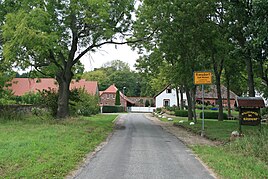
Eastern entrance from the L 55
|
|
Riesdorf is a district of Möckern in the Jerichower Land district in Saxony-Anhalt .
geography
The village is located two kilometers southwest of Lübars in the very wooded and 25,063 hectare protected landscape area Möckern-Magedeburgerforth . The district of the place belongs to the western Fläming plateau , a heather or grassy forest landscape of the north German lowlands. The terrain here reaches heights of around 80 meters.
The streams and ditches to the west and east of the village flow to the Ihle river on the northern edge of the village . This tributary of the Elbe rises only about three kilometers northeast of here.
history
The first documentary evidence of the place can be found 1368-1381 in the oldest loan books of the Magdeburg archbishops under villa Richerstorp . From the year 1375, then under the name Riecherstorp and 1450 as Wüstung Rigestorp and Riechersdorf there are further documents. Even if the village ceased to exist around 1450 and had to be described as a desert, the mill that was already in existence at that time continued to exist.
In 1568 Hanss v. Barbi fiefdomed the village with the old still existing mill. This fiefdom was renewed on December 1, 1646.
In 1781 the manor belonged to a certain Burchardt , who sold the Riesdorf mill, including the associated residential and farm buildings, as well as their fields and meadows, to the Ahlemann brothers from Loburg in the same year .
In 1782 a total of 65 lived in the small village, in 1818 only 44 and in 1842 again 68 exclusively Protestant residents. All goods by Klein Lübars the parish and started school , because here lacked the appropriate facilities. In 1842 , the manor that was eligible for the Landtag belonged to a Mr. Müller , who also had local jurisdiction.
At that time, the manor included a distillery, a water and oil mill, a jug and eight houses. The estate's own land comprised 540 acres of fields, 42 acres of meadows, 16 acres of gardens and 50 acres of woodland , i.e. forest areas.
The regular operation in the now very old mill was stopped in 1905 and the building was completely demolished in 1919 by the new owner.
The amalgamation of the village with the neighboring Klein Lübars to the north to form an independent municipality of Klein Lübars-Riesdorf came to an end on July 1, 1950 through the merger with Groß Lübars and Glienicke . Until the reclassification on July 1, 2002, the village was a district of the community Lübars, today also a district of the city of Möckern.
Sons and daughters of the place
- Otto Schumann (1903–1948), politician and member of the state parliament
Web links
- Riesdorf in the historical directory of the association for computer genealogy
Individual evidence
- ↑ City of Möckern - Main Office (ed.): Development of the inhabitants in the districts and localities of the city of Möckern - Basis: City residents' registration file - as of December 31, 2018 . January 25, 2019.
- ↑ Main statute of the city of Möckern in the version of September 25, 2014 - including 1st and 2nd amendment . June 1, 2018 ( full text [PDF; 115 kB ; accessed on December 28, 2018]).
- ↑ Map services of the Federal Agency for Nature Conservation ( information )
- ↑ Location of Riesdorf according to Geospatial services. Protected areas in Germany. Federal Agency for Nature Conservation, accessed on April 18, 2013 (excerpt).
- ^ Herbert Sange: Bishop Albrecht III. from Halberstadt . Halle 1932, p. 10 ff .; books.google.de
- ↑ Gustav Reischel: Desert science of the districts Jerichow I and Jerichow II . Historical Commission, 1930, p. 400; books.google.de
- ^ Historical sources of the Province of Saxony and the Free State of Anhalt . Landesgeschichtliche Forschungsstelle, Historical Commission, p. 14; books.google.de
- ↑ Historical Commission for the Province of Saxony and for Anhalt (ed.): Historical sources of the Province of Saxony and the Free State of Anhalt . Volumes 8–9. Self-published by the State Historical Research Center, Magdeburg, p. 193 ( Google Books [accessed January 24, 2014]).
- ↑ Eugen Huhn: Handbook from the administrative districts of Magdeburg . 1842, p. 155, Textarchiv - Internet Archive
- ^ Historical sources of the Province of Saxony and the Free State of Anhalt . Landesgeschichtliche Forschungsstelle, Historical Commission, p. 382; books.google.de

