
Loburg
|
Loburg
City of Möckern
|
|
|---|---|
 |
|
| Height : | 77 m above sea level NHN |
| Area : | 44.39 km² |
| Residents : | 2034 (Dec. 31, 2018) |
| Population density : | 46 inhabitants / km² |
| Incorporation : | January 1, 2009 |
| Postal code : | 39279 |
| Area code : | 039245 |
 |
|
As a district of Möckern, Loburg is a titular town in the district of Jerichower Land in Saxony-Anhalt .
geography
Loburg is located nine kilometers east-southeast of Möckern, 22 kilometers southeast of the district town of Burg and 30 kilometers east of the state capital Magdeburg . The place is on the upper reaches of the Elbe tributary Ehle in West Fleming and in the north and west the protected landscape area Loburger Vorflming extends to the outskirts.
The immediate area is dominated by agriculture, further north extends a larger forest area. The large Altengrabow military training area begins six kilometers to the east . There, located in the Loburg district, is the highest elevation in the Jerichower Land district, 127 m above sea level. NHN high Jerusalem . Loburg is a station on the Romanesque Road . The districts of Bomsdorf , Diesingshof , Padegrim , Rottenau and Wahl belonged to the former town .
history


In 965, Emperor Otto I assigned the "civitas Luborn" to the Magdeburg Mauritius Monastery , it is Loburg's first documented mention. In their place, however, there was a Slavic hill fort in the Gau Moresceni as early as the 8th century . It was converted into a border castle in the 10th century to secure the German settlement operated by Otto and became the center of a castle award. The castle dominated the important military and trade routes in the direction of Zerbst, which, coming from Burg and Brandenburg, met here. However, it was destroyed again during the Slav uprising of 983 . The villages Möckernitz and Ziemitz, which were built around the castle, suffered the same fate. While both places were rebuilt at the beginning of the 13th century, the Burgrave of Lubborch did not build a new castle until 1162 and 1200.
In 1207 the two villages merged and received city rights under the name Loburg. The fortification that was then built by a city wall with three gates did not include the former village of Ziemitz, so that it was repeatedly attacked by looters. It was then abandoned by its residents, who settled behind the protection of the city walls, and fell into disrepair, together with its three-aisled basilica from the 12th century.
In the course of the Middle Ages, Loburg was given as a fiefdom by the Moritz monastery to several changing noble families. In addition, the families targeted by Barby and from Wulffen manors and the von Randow had here possession. The von Wulffen in particular were very involved in the city. In 1581, Eustachius von Wulffen initiated the extensive renovation of the St. Lorenz town church. There were frequent disputes about the rights of the city between the citizens and the feudal families, which in 1598 and 1614 culminated in real uprisings. The elaborate construction of the town hall in 1609 testifies to the self-confidence of the citizens.
After the Thirty Years' War Loburg came under the rule of Brandenburg - Prussia . Since 1680 Loburg was directly subordinate to the Duchy of Magdeburg as a so-called Immediatstadt . There it was initially in the Genthiner district, which later became District I with the capital Burg . In 1716 a garrison was moved to the city, and towards the end of the 18th century Prussia set up a customs office here. After the reorganization of the Jerichow I district through the Prussian administrative reform of 1815, Loburg was the seat of the district administration from 1850 to 1877.
The Biederitz – Loburg railway connection opened on October 1, 1892, and the narrow-gauge railway of the small railways of the Jerichow I district to Lübars (and thus on to Burg , Ziesar , Gommern and Pretzien ), which was completed on April 20, 1903, had only minor effects on the economic development of the City. Even after the construction of the railway, agriculture continued to dominate at a stagnating level. The starch factory is worth mentioning as an industrial employer based on the supply of raw materials from the surrounding farms.
In 1885 Loburg had 2179 inhabitants. On September 30, 1928, the three manor districts Loburg I, Loburg II and Loburg III were combined with the town of Loburg, whereby the Wendgräben manor part of the Loburg III manor district was added to the rural community of Zeppernick.
After the end of the Second World War , the Soviet Army established a local command in the Loburg town hall until 1948. From July 25, 1952 to June 20, 1957, Loburg was once again the district town. The Loburg district was dissolved and Loburg was assigned to the Zerbst district . Agriculture also remained an important economic factor during the GDR era, and branches of the fittings and clothing industry were also established there. In 1980 the population was 3,150.
After German reunification, Loburg was incorporated into the newly created district of Anhalt-Zerbst . By designating two industrial areas, the city succeeded in relocating a number of new production companies. Until 2004 Loburg was the central location of an administrative community with seven affiliated locations. From January 1, 2005 to June 30, 2007, the city belonged to the Elbe-Ehle-Nuthe administrative community based in Zerbst. Since July 1, 2007, the city has belonged to the Möckern-Loburg-Fläming administrative community based in Möckern and to the Jerichower Land district .
On January 1, 2009 Loburg was incorporated into the town of Möckern .
politics
Local mayor is Gabriele Schmohl.
flag
The flag was approved by the county on December 23, 2008.
The flag is striped red and white (1: 1) (horizontal shape: stripes running horizontally, lengthways shape: stripes running vertically) and centered with the city coat of arms.
Town twinning
The sister city is the North Rhine-Westphalian municipality of Ostbevern . One reason for the partnership was the Loburg moated castle of the same name in Ostbevern.
Attractions
- The Protestant Church of St. Laurentius and the Loburg Town Hall are in the center of the village.
- The ruins of the Church of Our Lady are located in the eastern part of Loburg south of the B 246.
- At the western entrance to the village, on the northern edge of the road, stands the medieval keep as a remnant of the former Loburg .
- The station with its ensemble of water tower , water crane and engine shed, which has been preserved from the 19th century, as well as a historic train can be visited in Bahnhofstrasse.
- The Storchenhof can be found on Chausseestrasse, with guided tours providing an insight into the life of storks. In addition to storks, other birds taken for care are shown in several enclosures.
- The former Catholic Church of St. Mary is on the eastern edge of the village.
- Wendgräben Castle is about four kilometers north of the village. It was built in 1910 for the von Wulffen noble family from Loburg .
- the Barbysches Gutshaus , which is operated as a café and restaurant, and the Münchentorturm of the historic city fortifications

Church ruins Church of Our Dear Women
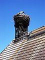
Storchenhof Loburg


Infrastructure
Loburg is on federal highway 246 . The Ziesar (eastward) and Burg-Ost (westward) junctions of federal motorway 2 are each about 20 kilometers away.
On the railway line Biederitz-Altengrabow Loburg by a railway station on the run no more passenger trains in December 2011th
The public transport system is, among other things by the PLUSBUS of the country's network of Saxony-Anhalt provided. The following connection leads from Loburg:
- Line 720: Loburg ↔ Möckern ↔ Königsborn ↔ Magdeburg
Bus traffic in the Jerichower Land district is operated by the Jerichower Land local transport company.
Personalities
- Andreas von Barby (1508–1559), Danish politician and Bishop of Lübeck
- Erduin Julius Koch (1764–1834), German literary historian and classical philologist
- Friedrich Koch (1769–1849), German teacher and school councilor
- Wilhelm von Barby (1795–1883), Prussian lieutenant general
- Friedrich von Barby (1801–1871), Prussian major general
Web links
- Loburg in the historical directory of the association for computer genealogy
- The Dampfzug-Betriebsgemeinschaft e. V. Loburg Working Group
- Place Loburg on the side of the city of Möckern
- Reconstruction drawing by Wolfgang Braun
Individual evidence
- ^ The localities of the city of Möckern. City of Möckern, accessed on January 17, 2019 .
- ↑ City Möckern - Office (ed.): Development of inhabitants in the districts and villages of the town Möckern - basis: resident registration file of the city - 31 status in December 2018 . January 25, 2019.
- ↑ Main statute of the city of Möckern in the version of September 25, 2014 - including 1st and 2nd amendment . June 1, 2018 ( full text [PDF; 115 kB ; accessed on December 28, 2018]).
- ↑ Map services of the Federal Agency for Nature Conservation ( information )
- ↑ Handbook of the German Railway Lines: Opening dates 1835-1935, Mainz 1985, ISBN 3-921426-29-4
- ↑ Administrative region of Magdeburg (Ed.): Official Gazette of the Government of Magdeburg . 1928, ZDB -ID 3766-7 , p. 202 .
- ↑ StBA: Area changes on 01/01/2009
- ↑ local mayor. City of Möckern, accessed on September 30, 2019 .
- ↑ Official Journal of the District No. 26/2008, page 750
Localities and districts: Bomsdorf | Brandenstein | Brietzke | Buden | Dalchau | Dörnitz | Drewitz | Friedensau | Glienicke | Goebel | Grabow | Grünthal | Hobeck | Hohenziatz | Isterbies | Kähnert | Kalitz | Fight | Klein Lübars | Klepps | Krüssau | Küsel | Country house | Loburg | Lübars | Luetnitz | Lüttgenziatz | Magdeburgerforth | Pabsdorf | Räckendorf | Reesdorf | Riesdorf | Rietzel | Rosian | Rottenau | Schweinitz | Stegelitz | Stresow | Tea | Tryppehna | Choice | Wallwitz | Wendgräben | Wörmlitz | Wüstenjerichow | Zeddenick | Zeppernick | Brick village | Ziepel
Settlements: Altengrabow | Diesingshof | Eckebusch | Lochow | Lühe | Padegrim | Schweinitzer Huts | Waldrogäsen - Desolations: Gloine | Heathen Blessing | Dump | Nyblitz | Portez | Thumbermark