Isterbies
|
Isterbies
City of Möckern
Coordinates: 52 ° 5 ′ 13 ″ N , 12 ° 7 ′ 36 ″ E
|
|
|---|---|
| Height : | 86 m above sea level NHN |
| Residents : | 119 (December 31, 2018) |
| Incorporation : | 1st January 1974 |
| Incorporated into: | Rosian |
| Postal code : | 39279 |
| Area code : | 039245 |
|
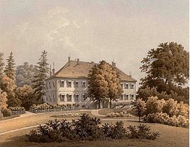
Isterbies manor around 1860 - Alexander Duncker collection
|
|
Isterbies is a district of Möckern in the Jerichower Land district in Saxony-Anhalt .
geography
The village is two kilometers southwest of Rosian . Less than two kilometers south of here, the district met with the county border, at the same northwestern border from the Fläming Nature Park and approximately 1.5 km to the north lies the 105 hectare large nature reserve Bürgerholz at Rosian . This is also an FFH area with the same name, to protect the floodplain forests to be found here with transitions to English oak and hornbeam forests in a complex with streams.
In terms of natural space , the place belongs to the Zerbster Land , an arable, open cultural landscape and 536 km² main unit of the superordinate main unit group of the Fläming in the north German lowlands . The Zerbster Land forms the southwestern roof of the Fläming to the Elbe and belongs to the catchment area of this river.
history
A first documentary evidence of the place can be found in 1370, however under the name Istewist . Later the village of Ystebis was sold to the parish of Ziesar . Archbishop Günther von Magdeburg approved this on September 16, 1427. In a document from 1562, the place name is then given as Ysterbiest .
A mill on the Ehle river in the Isterbies corridor is still mentioned in 1796, but it must have disappeared a short time later, because such a facility is no longer recorded in the maps from 1800 and later.
In 1848, according to a statistical representation of the administrative district of Magdeburg in the Prussian province of Saxony, there is a church village and manor suitable for the state assembly with 32 houses and 243 inhabitants. The estate also included a brick factory and the Kiepermühle wind and water mill , which, however, was not in the corridor.
On September 30, 1928, the manor district of Isterbies was united with the rural community of Isterbies. On July 25, 1952, the municipality of Isterbies was assigned to the Loburg district as part of an administrative reform . On June 20, 1957, the community was reclassified to the district of Zerbst . On January 1, 1974, it was incorporated into the community of Rosian. Since Rosian was incorporated into Möckern on January 1, 2007, Isterbies has been part of Möckern.
Personalities
- Gustav Rudolf von Bennigsen-Foerder (1770–1809), district administrator, inherited the local estate on April 14, 1795 and died here on May 22, 1809.
- Heiko Robert Garibian, a Berlin real estate agent, acquired the historic manor in 2000 in a desolate state. The mansion has since been thoroughly modernized and is now used as a private residence. Today's view reflects the original condition of the mansion from 1793, which was faithfully reproduced in Alexander Duncker's lithograph from 1881.
Web links
- Isterbies in the historical directory of the association for computer genealogy
- Material on Isterbies in the Duncker Collection
Individual evidence
- ↑ City of Möckern - Main Office (ed.): Development of the inhabitants in the districts and localities of the city of Möckern - Basis: City residents' registration file - as of December 31, 2018 . January 25, 2019.
- ↑ Main statute of the city of Möckern in the version of September 25, 2014 - including 1st and 2nd amendment . June 1, 2018 ( full text [PDF; 115 kB ; accessed on December 28, 2018]).
- ↑ Federal Agency for Nature Conservation: Location of Isterbies in accordance with Geospatial services. Protected areas in Germany. Retrieved April 17, 2013 (excerpt).
- ↑ Map services of the Federal Agency for Nature Conservation ( information )
- ^ Adolph Friedrich Riedel : Codex diplomaticus Brandenburgensis. Collection of documents (among others). 1869, p. 50 , accessed April 17, 2013 .
- ↑ Gustav Reischel: Wüstungskunde der Kreis Jerichow I and Jerichow II. Self-published by the Historical Commission, 1930, p. 398 , accessed on April 17, 2013 .
- ↑ Historical Commission: Historical Sources of the Province of Saxony and the Free State of Anhalt. Self-published by the State Historical Research Center, p. 381 , accessed on April 18, 2013 .
- ↑ Eugen Huhn: The Kingdom of Prussia represented geographically, statistically and topographically. 1848, p. 57 , accessed April 19, 2013 .
- ↑ Administrative region of Magdeburg (Ed.): Official Gazette of the Government of Magdeburg . 1928, ZDB -ID 3766-7 , p. 202 .
- ↑ Federal Statistical Office (Ed.): Municipalities 1994 and their changes since 01.01.1948 in the new federal states . Metzler-Poeschel, Stuttgart 1995, ISBN 3-8246-0321-7 , pp. 314-315 .
- ^ Rolf Straubel : Biographical manual of the Prussian administrative and judicial officials 1740–1806 / 15 . In: Historical Commission to Berlin (Ed.): Individual publications . 85. KG Saur Verlag, Munich 2009, ISBN 978-3-598-23229-9 , pp. 61 ( limited preview in Google Book search).
