Pabsdorf
|
Pabsdorf
City of Möckern
Coordinates: 52 ° 11 ′ 40 ″ N , 11 ° 58 ′ 28 ″ E
|
|
|---|---|
| Height : | 65 m above sea level NHN |
| Area : | 29 hectares |
| Residents : | 63 (December 31, 2018) |
| Population density : | 217 inhabitants / km² |
| Postal code : | 39291 |
| Area code : | 039221 |
|
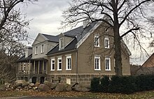
Möckeraner Strasse in Pabsdorf, view from the west
|
|
Pabsdorf is a district of Möckern in the Jerichower Land district in Saxony-Anhalt .
geography
The village is located six kilometers north of Möckern on the western edge of the very wooded landscape protection area (LSG) Möckern-Magdeburgerforth . This 25,063 hectare LSG is part of the Burg-Ziesarer Vorfläming natural area , which forms the western end of the Fläming . The local part of the Pabsdorf Forest , also called Pabsdorf Forest , reaches heights of 70 meters here.
Located on the southwestern edge of a large clearing, the place is otherwise surrounded by forest. To the south of the village there is a small depression through which the Bullengraben brook flows from east to west . The water flows into the Kammerforthgraben a good two kilometers west of here . Coming from Stegelitz in the west, it flows towards the Ihle . This small tributary of the Elbe is located just under two kilometers north of here and, as a still very natural flowing body of water in Vorfläming, belongs to the FFH area Ihle between Friedensau and Grabow .
history
In 1785 the place was designated and described as a Vorwerk in the First District of the Jerichowschen Kreis . A total of 53 residents are said to have lived here as early as 1782 and 13 births and 19 deaths were recorded in the previous ten years. In addition, a sheep farm, a forester's house from 1761, nine fireplaces, 1,800 acres of wood , 750 acres of fields, 120 acres of meadow and three acres of garden land are said to have belonged to it. Already at this time the Vorwerk was parish off to Möckern and belonged to the baron von Hagenschen Amte Möckern .
In 1847 Pabsdorf was listed in the "Topographical-Statistical Handbook of the Prussian State". As Vorwerk with forester and shepherd, 9 houses and 80 souls and belonging to Möckern.
Until 1965 Pabsdorf had its own train station and was accessible via a 750 mm narrow-gauge railway from Burg via Stegelitz – Pabsdorf – Lüttgenziatz to Lübars. The stop at kilometer 17.4 was the Pabsdorf train station.
After the end of the Second World War, the Counts of Hagen were expropriated by the land reform ordered by the Soviet occupying forces.
Attractions
About 2.5 km north of Pabsdorf is the Neolithic large stone grave Grabow .
Web links
- Pabsdorf in the historical directory of the association for computer genealogy
Individual evidence
- ↑ City of Möckern - Main Office (ed.): Development of the inhabitants in the districts and localities of the city of Möckern - Basis: City residents' registration file - as of December 31, 2018 . January 25, 2019.
- ↑ Main statute of the city of Möckern in the version of September 25, 2014 - including 1st and 2nd amendment . June 1, 2018 ( full text [PDF; 115 kB ; accessed on December 28, 2018]).
- ↑ Federal Agency for Nature Conservation: Location of Pabsdorf according to Geospatial services. Protected areas in Germany. Retrieved April 20, 2013 .
- ^ Johann Ludwig Heineccius: Detailed topographical description of the Duchy of Magdeburg . 1785, p. 239 ( digitized version in the Google book search).
- ^ Eduard Messow : Topographical-statistical manual of the Prussian state . Second volume: L – Z. Publishing house by Emil Baensch, Magdeburg 1847, p. 149 ( digitized in Google Book Search [accessed January 22, 2019]).

