
São Paulo (State)
| Estado de São Paulo | |||
|---|---|---|---|
  |
|||
| Symbols | |||
|
|||
| Basic data | |||
| Country | Brazil | ||
| Capital | São Paulo | ||
| surface | 248,222 km² | ||
| Residents | 45,919,049 (estimate as of July 1, 2019) | ||
| density | 185 inhabitants per km² | ||
| ISO 3166-2 | BR-SP | ||
| Website | www.saopaulo.sp.gov.br (Brazilian Portuguese) | ||
| politics | |||
| governor | João Doria Júnior (2019-2023) | ||
| Political party | PSDB | ||
| economy | |||
| GDP | 1.858 billion R $ 42,198 R $ per capita (2014) |
||


Coordinates: 22 ° S , 49 ° W
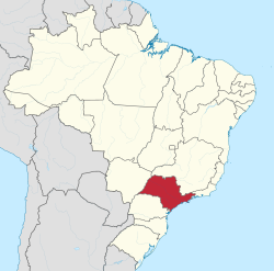
The state of São Paulo (officially Estado de São Paulo ; abbreviation SP ) is the most populous and economically most important of the 27 Brazilian states . It is located in the southeast of Brazil and borders in the north and northeast on Minas Gerais , in the east on the state of Rio de Janeiro and the South Atlantic , in the south on the state of Paraná and in the west on Mato Grosso do Sul . It is divided into a total of 645 communities . The capital of the state is called São Paulo Capital . The residents of the state are known as Paulistas , while the residents of the capital call themselves Paulistanos .
geography
Overall, the state is slightly larger than Great Britain and has 622 kilometers of coastline to the Atlantic Ocean . It comprises two different natural regions: the coastal region and the plateau. The coastal region is the less pronounced - narrow in the northern section and particularly wide towards the south, where it is taken up by the Baixada de Ribeira de Iguape. Within the coastal region there are beaches, mangrove forests , isolated massive terraces, resulting in rugged cliffs on the seashore with relatively flat beaches. The mountain silhouette of the Serra do Mar always appears in the background , which borders the planalto of the hinterland towards the sea. The area of the state of São Paulo in 2018 was 248,222 km², which is only about three percent of the area of Brazil.
From the sandy beaches of the Atlantic to the Pedra da Mina ( 2770 m ) in the Serra da Mantiqueira , São Paulo offers a diverse landscape. The main rivers are the Rio Tietê (1,130 km), Rio Paranapanema , Rio Grande , Rio Turvo , Rio de Peixe , Rio Paraíba do Sul and Rio Piracicaba .
Population development
The population was around 41 million people at the 2010 census ( population 41,262,199). That corresponds to about 22% of the total population of the country. The population density in 2010 was about 166 people per square kilometer. The population was estimated at 45,919,049 inhabitants as of July 1, 2019. According to a forecast by the Brazilian statistical office, the state will have reached a population of 47.2 million by July 2020. It will accommodate around eight percent of the entire population of Latin America .
Population development since 1960
| year | population |
|---|---|
| 1960 census | 12,974,699 |
| 1970 census | 17,958,693 |
| 1980 census | 25.375.199 |
| 1991 census | 31,588,925 |
| 2000 census | 37.032.403 |
| 2010 census | 41.262.199 |
| 2019 estimate | 45,919,049 |
Cities


The state of São Paulo is divided into 645 municípios as the next higher administrative units. The largest cities according to the IBGE's population estimates as of July 1, 2019 are:
- Sao Paulo - 12,252,023
- Guarulhos - 1,379,182
- Campinas - 1,204,073
- Sao Bernardo do Campo - 838.936
- São José dos Campos - 721,944
- Santo André - 718.773
- Ribeirão Preto - 703.293
- Osasco - 698,418
- Sorocaba - 679,378
In addition to these municipalities, the state was also divided into 15 statistical-geographical mesoregions and 63 microregions until 2017 .
coat of arms
The heraldic coat of arms of the region consists of a red Portuguese shield with an upright sword over two crossed branches, laurel on the right, oak on the left, with the blade separating the letters "SP", all in silver. There is a silver star above the shield. The shield is carried by two flowering branches of coffee in their colors, which are crossed at the base of the shield. The Latin motto of the state can be read on a red ribbon in silver letters: Pro Brasilia Fiant Eximia (“Let great things happen for Brazil”).
The coat of arms was designed by the painter Wasth Rodrigues and introduced by decree by Governor Pedro Manuel de Toledo during the constitutional revolution of 1932, of which the obelisk at Ibirapuera Park commemorates. After 1937 it was replaced by other symbols until it was finally laid down in the new constitution in 1946.
politics

Geraldo Alckmin ( PSDB ) was governor from January 1, 2011 to April 6, 2018. The last lieutenant governor was Márcio França . On April 6, 2018, Márcio Luiz França Gomes from the Partido Socialista Brasileiro (PSB) took over the post from Alckmin. This was a prerequisite for the latter to be able to run for the 2018 presidential election.
After the elections in Brazil in 2018 , João Doria Júnior ( PSDB ) has been the 37th governor of the state of São Paulo since January 1, 2019 . Its lieutenant governor is Rodrigo Garcia ( DEM ).

João Doria Júnior, 37th Governor

Rodrigo Garcia, 27th lieutenant governor
2.jpg)

The supreme legislative body, the Legislative Assembly of São Paulo ( Portuguese Assembleia Legislativa do Estado de São Paulo , ALESP for short), is composed of 94 elected representatives ( deputados estaduais ). At the federal level, the state is represented by three senators and 70 federal representatives ( deputados federais ).
Economy and Agriculture

35–40% of Brazil's industrial production comes from São Paulo. In addition to the automotive and mechanical engineering industries , you will find the textile industry , chemical industry , food industry , etc. The metropolis of São Paulo is the financial and commercial center of Brazil. The state consumes a third of the country's electrical energy. Santos is a major overseas port for imports and exports .
The only aircraft manufacturer in South America and manufacturer of regional jets Embraer is based in São José dos Campos.
São Paulo has extremely fertile soils with the so-called Terras Roxas . Fruits , sugar cane , grain and coffee are grown away from the large metropolitan areas on the coast .
traffic
Road network
The road network has a total length of 195,026 kilometers, of which 1,146 km are federal highways and 18,645 km are state highways . 25,306 kilometers are paved. Among the main road links are Via Anchieta and Via Imigrantes (since 1976), they both connect São Paulo with Santos, Via Annexuera, it connects the capital with Campinas, Rodovia Fernão Dias, connects the capital with Belo Horizonte, Via Presidente Dutra, connects the capital with Rio de Janeiro, the Rodovia Castelo Branco, connects the capital with the west of the state - the São Paulo - Brasília connection, the BR-101 connects Santos with Curitiba in the south and Rio de Janeiro in the north.
Rail network
The rail network covers around 7,200 km. It opens like a fan on the heights of the Planalto and strives towards São Paulo like a funnel. To the south, towards the coast, only two of these lines run.
port
At Santos is the largest and most important port facility in Brazil. The port of São Sebastião is particularly used by tankers from the Brazilian oil company Petrobras . The Presidente Epitácio and Panorama river ports are important for the shipping of agricultural products, ores and products from iron foundries.
Airports
The most important airports are the international airport São Paulo-Guarulhos , the airport Viracopos in Campinas with mainly freight and the city- airport São Paulo-Congonhas - in the city of São Paulo, for inner-Brazilian traffic like the airlift every 30 minutes to Rio de Janeiro-Santos Dumont Airport .
Web links
- Governo do Estado do São Paulo website (Portuguese)
- Informative page about the state
- Website Empresa Paulista de Planejamento Metropolitano SA Macrometrópole Paulista (Portuguese)
Individual evidence
- ↑ a b c d São Paulo - Panorama. In: cidades.ibge.gov.br. IBGE , accessed September 5, 2019 (Brazilian Portuguese).
- ↑ IBGE: Notícias: Contas Regionais 2014: cinco estados responderam por quase dois terços do PIB do país. Retrieved March 6, 2017 (Portuguese).
- ^ IBGE: Cidades @ São Paulo. Retrieved May 22, 2020 (Brazilian Portuguese).
- ↑ Dimitrius Dantas: Alckmin renuncia e transmite cargo de governador ao vice Márcio França. O Globo, April 6, 2018, accessed July 22, 2018 (Portuguese).
Acre | Alagoas | Amapá | Amazon | Bahia | Ceará | ( Distrito Federal do Brasil ) | Espírito Santo | Goiás | Maranhão | Mato Grosso | Mato Grosso do Sul | Minas Gerais | Pará | Paraíba | Paraná | Pernambuco | Piauí | Rio de Janeiro | Rio Grande do Norte | Rio Grande do Sul | Rondônia | Roraima | Santa Catarina | São Paulo | Sergipe | Tocantins