
Miter
|
Miter
City of Ilmenau
|
||
|---|---|---|
 |
||
| Height : | 475 m | |
| Area : | 43.79 km² | |
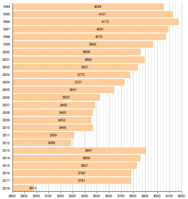
| Residents : | 2973 (Jan. 1, 2019) | |
| Population density : | 68 inhabitants / km² | |
| Incorporation : | 6th July 2018 | |
| Postal code : | 98694 | |
| Area code : | 036783 | |
Location of Gehren in Thuringia |
||


Gehren is a district of the city of Ilmenau in the Ilm district in Thuringia . It is located about eight kilometers east of Ilmenau in the valley of the Wohlrose between the Thuringian Forest in the south-west and the Long Mountain in the south-east, which introduces the Thuringian slate mountains . Today Gehren is the seat of the Thuringian Forest Workers School, where foresters are trained.
Gehren had been the official seat since the Middle Ages. From there, the southeastern part of today's Ilm district around the places Langewiesen , Gehren and Großbreitenbach , which once belonged to the Schwarzburg special houses suzerainty , was administered. The administrative seat was the office building, which was demolished in 1997. At the end of the 19th century industrialization began in Gehren and some larger factories, such as B. the sawmill at the train station came into being and the place developed into a city.
geography
Gehren is located on the northeastern edge of the Thuringian Forest about eight kilometers east of Ilmenau . The Thuringian Slate Mountains begin to the south-east of the city , while the hills of the Paulinzella red sandstone region extend to the north. Gehren is located at the confluence of the Schobse in the Wohlrose , a tributary of the Ilm . In addition, the Lohme runs as the western border to Langewiesen . To the north of Gehrens between the Ilm and the Wohlrose there is a flat heather area in which the Gehrener wetland , one of the largest natural wetlands in the Thuringian Forest, is located. Close to Gehren are the Heideteich and the Löschwasserteiche, a little further north the Water Lily Pond and northeast of the city the Zweizapfenteiche and the Sorger Ponds. The wetland is about 450 meters above sea level and is a nature reserve .
While there are hardly any elevations in the district to the north of Gehrens, the south of the area is characterized by low mountain ranges. To the west of Gehrens lies the Große Tragberg (588 m), south on the other side of the Lohme the Hexenstein (659 m), further south after the Schobse valley the Brandkopf (727 m) and further towards the Thuringian Forest the Steinberg (758 m) as the highest point of the city limits. After the valley of the Wohlrose, the Silberberg (771 m), which gives its name to the Silberberg tunnel, follows south of the village in the Möhrenbach district . From Gehren to the south a wide valley extends to Möhrenbach. Southeast of Gehrens lies the Langer Berg massif , which marks the transition to the Thuringian Slate Mountains and is 808 meters high. He is also the namesake of the Gehrener administrative association. To the east of Gehren there is an easy crossing to Königsee from the catchment area of the Ilm to the catchment area of the Saale , over which trade routes have run since early times. Today the federal highway 88 takes this route.
The north, south-west and south-east of the district are forested, in between there are wet meadows and pastures with an open landscape along the valleys.
Geologically, Gehren lies at the intersection of three regions and in a fault zone , so that a diverse geological profile results. To the southwest is the Thuringian Forest ( porphyry ), to the north is the Paulinzella red sandstone hill country and to the southeast is the Thuringian Slate Mountains ( slate ).
While the original town center was quite modest in size, from the 19th century on, Gehren expanded mainly to the north-east, as the railway line ran here and there was enough flat space for larger factories to settle there. Later on, residential quarters also emerged in the west and south-east. The city also expanded along the Schobse and Wohlrose valleys to the southwest and south.
history
The moated castle Gehren was mentioned as a stable defensive complex as early as 1118. In the 14th century it was owned by the Lords of Berlstedt and in 1464 passed to the Counts of Schwarzburg-Sondershausen.


The first documented mention of Gehrens comes from the year 1299. Various sources also speak of a first mention in 1105, on the basis of which the 850th anniversary celebration in 1955 was based. The name is derived from Gern for triangular parcel. This could mean the parcel enclosed by Schobse and Wohlrose . The place developed around the watch tower , which served to guard a trade route. The von Bernstedt family from Jesuborn was enfeoffed with securing this trade route . She was allowed to collect tribute and keep it. Lieutenants were the counts of equals . Later, through several intermediate steps, the guard tower became the Gehrener Castle , which burned down on September 11, 1933 and was not rebuilt. Its ruins can still be seen in the castle park today. These ruins still reveal the old buildings on the moated castle . 1399 received Count Günther XXVIII. von Schwarzburg took over the office of Gehren as a fiefdom from the German King Wenzel . Finally, the Schwarzburger bought the Gehren office in 1464 for 300 Rhenish guilders from the von Bernstedt family . Several sales by the city followed by 1599. Since then, however, it has always been in the possession of the Schwarzburger. In the 15th century, Gehren's first ironworks was built on the Günthersfeld, in which the iron ore extracted from nearby was processed. It was enlarged several times in the course of its existence and last served as a porcelain factory . There was an uprising by the farmers of Gehren on April 23, 1525 as part of the Peasants' War . They were u. a. also involved in the sacking of the Paulinzella monastery and the siege of Stadtilm . The Reformation was introduced in Schwarzburg and thus also in Gehren in 1533. In 1549 Gehren was referred to as a town for the first time .
In 1625 and 1635 the plague raged in Gehren and claimed a total of 318 deaths. Looting occurred during the Thirty Years' War in May 1640. 34 houses were burned down. The villagers fled and lived in the forest near the city for eight weeks. Looting - albeit to a lesser extent - also took place in 1756 during the Seven Years' War .
On September 7, 1749, 90 residential buildings were destroyed in a severe local fire. An epidemic epidemic in 1772 killed 113 citizens. The Gehrener Schloss burned down in 1796, but the damage remained within the repairable area. The classical church of Gehrens was inaugurated in 1834. Its construction costs amounted to 18,000 thalers , and its tower is 27 meters high. In the same year the first newspaper for the Gehren office was founded, the Gehrener Bezirksblatt .
In the early 19th century, Gehren experienced economic hardship, which led to over 130 people emigrating to the USA in 1852 alone . The place got the city charter in 1855. After the city received a rail connection to Ilmenau in 1881 , the industry rapidly grew rapidly. In 1883, Theodor Degenring from Eisenach bought the ironworks on Günthersfeld, which had become unprofitable, and converted it into a porcelain factory, which at times employed over 400 people. The sawmill was founded in 1885. The last major fire in the city's history in 1899 killed 22 houses. Gehren belonged to the sovereignty in the principality or Free State of Schwarzburg-Sondershausen until 1920 , in which it was the official seat. In addition to the city, the Gehren office also included the towns of Angstedt , Wümbach , Langewiesen , Oehrenstock , Jesuborn , Pennewitz , Willmersdorf , Gillersdorf , Großbreitenbach , Masserberg , Oelze , Altenfeld , Möhrenbach and the parts of Neustadt north of the Rennsteig . In 1922 the district of Arnstadt was founded, to which the entire administrative area with the exception of Katzhütte belonged.
During the Second World War , 200 women and men, mainly from the Soviet Union, had to do forced labor : in the Th. Kirsch & Söhne sawmill , in the Günthersfeld porcelain factory , in the Vorbrüggen & Co. company , in the Wiesel lacquer and paint factory and in the Wiegand & Schmidt glassworks .
In 1952, the district of Ilmenau was formed from the southern part of the Arnstadt district, to which Gehren then belonged . In 1953 Gehren was the first place in the Ilmenau district in which an LPG was founded. In 1994 the Ilmenau district became part of the Ilm district . In the same year the administrative community Langer Berg was founded, which had its seat in Gehren.
Since July 1, 1950, the village of Jesuborn, one kilometer to the east, belonged to the city of Gehren.
On December 31, 2013, the neighboring community Möhrenbach was incorporated and the rural community of Gehren was formed.
The state government first spoke out in favor of a merger with the Großbreitenbach administrative community, which the city council rejected. On July 6, 2018, the administrative association Langer Berg and the city of Gehren were dissolved and incorporated into the city of Ilmenau with other communities.
Population development
Values from 1994: data as of December 31 of the year; Source: TLS
|
|
|
|
|
politics
District Council
The district council for Gehren was elected for the first time in the local elections in Thuringia on May 26, 2019. Previously, the former members of the Gehren city council had served as local councilors since the incorporation into Ilmenau.
The district council has 10 members and the district mayor.
Mayor / district mayor
On May 26, 2019, during the local elections in Thuringia , a new honorary district mayor for Gehren was voted. This is no longer responsible for the districts of Jesuborn and Möhrenbach at the same time. Of the three applicants who stood, no candidate was able to collect more than half of the valid votes cast, so that there was a runoff election on June 11, 2019. Sabine Krannich (DIE LINKE) was elected for a five-year term of office. Prior to that, Hartmut Breternitz (CDU) was mayor of Gehren from 1994 to 2005, before Ronny Bössel (FBG Gehren) followed from 2005 to 2019, most recently as mayor of the district. Until 2011 the office of mayor was full-time, since then it has been carried out on a voluntary basis.
coat of arms
Blazon : "In gold on green ground, a wild man with a crown of leaves and a foliage apron, holding a rooted spruce in his left hand."
The wild man is likely to be a modification of what was originally a different coat of arms figure, because the first seal from the 16th century shows a man walking from right to left in a high hat and long coat, who holds a staff, probably the Schulzen staff, in his hand. The coat of arms was apparently changed to express gratitude to the Schwarzburg dynasty, which ran a wild man as a shield holder, for the granting of city rights in 1855. The spruce stands for the abundance of wood in the area and the once important Gehrens wood industry.
Town twinning
A town partnership has existed with Nidderau in Hesse since September 1, 1990.
Culture and sights
In the city center, the typical appearance of the Thuringian Forest has been preserved: to the right and left of narrow streets, slated houses stand close together.
church

The market square is in the center of the village. On its north side is the city church, which is dedicated to St. Michael . It is a large, classical gallery hall with flat ceilings in the formal language of Karl Friedrich Schinkel . The church was built between 1830 and 1834 instead of a previous building from 1521. The church's pulpit altar dates from 1895, as does the Sauer organ with 23 registers, which replaced an instrument from the Bach era. On the ground floor of the tower is the grave of the Jesuborn knight Volkmar von Bernstedt from 1597. The three bronze church bells (including one from 1476) were melted down in 1917 and replaced in 1918 by three cast-iron bells that are still there today. As Gehren grew in the 18th century, the previous church became too small and a new church was built in Oberen Marktstrasse west of the old one by 1729. This new church was destroyed in a fire in 1749, so that the old church on the market square was used again. However, this was still too small, so that the new building of today's church began in 1830. Finally, on November 4, 1834, the dedication service took place. The tower initially had a flat roof in Schinkel's style, which was replaced in 1868 by the current spire. The parish of Gehren has been Protestant since the introduction of the Reformation in the 16th century. In addition to the church, the parish also includes the village churches of Jesuborn and Möhrenbach .
lock

The first buildings (for example in the form of a waiting tower) were probably built here as early as the 12th century on a trade route from Erfurt to Nuremberg . In 1308 the Lords of Berlstedt erected a few more buildings here (north wing), which in 1464 passed into the possession of the Counts of Schwarzburg . During this time they built the south wing. From 1574 the castle was expanded in the Renaissance style and the north and south wings were combined into one structure. Sandstone blocks from the abandoned Paulinzella monastery were partly used for this purpose. The castle chapel was built in 1666. In the years that followed, the castle served as a hunting and summer residence for the counts and princes of Schwarzburg-Sondershausen ; Prince Günther I even used it as a residence between 1720 and 1740. In 1918 it became the property of the State of Thuringia and was mainly used as a residential building. The castle was destroyed in a fire on September 11, 1933 and most of it was torn down in the following years, leaving only the remains of some of the surrounding walls. Between 1997 and 2001 the ruins were secured, partially restored and made accessible. It is surrounded by the extensive castle park in the style of an English garden.
Other structures
The town hall, a simple baroque building that was extensively renovated in 2008, is located on the south side of the market square.
There is a mourning hall in the cemetery in the south of the city. It was built between 1897 and 1900 in neo-Gothic style by the Gehrener master builder Domhardt. It is an impressive testimony to historicism, with the interior painting dating from 1921/22. The lead glass windows were destroyed by US artillery fire in 1945, with one exception. In 2003 the mourning hall was restored.
Economy and Transport

Gehren was once an important industrial center. The industrial area is located in the north of Mitten. There used to be a glass , porcelain and wood industry in Gehren . The Gehrener sawmill was the largest in the GDR . However, it was founded around the turn of the century, then under the name Kirsch with over 800 employees at times. Today there are various medium-sized companies in Gehren that have settled in the industrial park in the north of the city.
Gehren became famous for the manufacture of soft toys . The plush toy factory still produces today. In contrast to many other companies, it has been able to assert itself on the free market since 1990. However, the long-standing sales point was closed at the end of 2011 and orders are currently only possible via the Internet.
The largest company in Gehren today is SZW Prophet GmbH, an automotive supplier with 100 employees.
traffic

Gehren is on the B 88 Ilmenau - Rudolstadt , for which a bypass is planned in the Federal Transport Infrastructure Plan 2030 if required. In Gehren it is crossed by the state road 1047 Gräfinau-Angstedt - Großbreitenbach . The city is heavily burdened by through traffic from the A 71 (junction Ilmenau-Ost) into the slate mountains, the through traffic is characterized by narrow streets and intersections. From 1881 to 1997 Gehren had a railway connection over the Ilmenau – Großbreitenbach line . The Gehren (Thür) Stadt stop was in the west and the Gehren (Thür) train station in the east.
Public facilities
Gehren is the location of the Thuringian Forest Workers School, where all foresters in the country are trained.
Personalities
- Johann Michael Bach (1648–1694), composer; was town clerk in Gehren
- Maria Barbara Bach (1684–1720), daughter of Johann Michael Bach and first wife of Johann Sebastian Bach
- Udo Kier (* 1944), actor; bought the school in Gehren in 2008
- Heinrich Balthasar Roth (1639–1689), legal scholar
literature
- Heinrich Pausch: City of Gehren - 850 years old town . Gehren City Council, Gehren 1955.
- City of Gehren, Festival Committee for Festschrift and Public Relations [Hrsg.]: Gehren and its history: 150 years of city law; 1855-2005 . RhinoVerlag, Ilmenau and Weimar, 2005. ISBN 3-86636-901-8
- Olaf Batke: The Gehrener Castle . City administration of Gehren, Gehren, 1993.
Web links
Individual evidence
- ↑ a b Official Gazette of the City of Ilmenau 02/2019. In: Official Gazette of the City of Ilmenau. City of Ilmenau, March 8, 2019, p. 10 , accessed April 23, 2019 .
- ^ Lexicon of cities and coats of arms of the GDR , VEB Bibliographisches Institut, Leipzig 1984
- ↑ From Gehren's chronicle at www.th.schule.de ( Memento from February 11, 2008 in the Internet Archive )
- ↑ Thomas Bienert: Medieval castles in Thuringia. Wartberg Verlag, 2000, ISBN 3-86134-631-1 , p. 125.
- ↑ Thuringian Association of the Persecuted of the Nazi Regime - Association of Antifascists and Study Group of German Resistance 1933–1945 (ed.): Heimatgeschichtlicher Wegweiser to places of resistance and persecution 1933–1945, series: Heimatgeschichtliche Wegweiser Volume 8 Thüringen, Erfurt 2003, p. 141 , ISBN 3-88864-343-0
- ↑ StBA: Area changes from January 1st to December 31st, 2013
- ↑ Government follows call from Gehren
- ↑ Thuringian Law and Ordinance Gazette No. 7 2018 of July 5, 2018 , accessed on July 6, 2018
- ↑ Population of the communities, fulfilling communities and administrative communities by gender in Thuringia . (html), accessed on August 11, 2019.
- ^ Thuringian State Office for Statistics (TLS): Area changes: Community 70018 Gehren, city . (html), accessed on August 12, 2019.
- ^ Thuringian State Office for Statistics (TLS): Area changes: Community 70029 Ilmenau, city . (html), accessed on August 12, 2019.
- ↑ a b City Administration Ilmenau: Official Gazette of the City of Ilmenau - Sonderamtsblatt 8/2019: Results of the runoff election of the district mayors of the districts of Gehren, Pennewitz and Wümbach on June 9, 2019 . June 21, 2019.
- ^ Thuringian State Office for Statistics: Elections in Thuringia, mayoral elections in Gehren. Retrieved May 1, 2020 .
- ^ New Thuringian Wappenbuch Volume 2, page 11; Publisher: Arbeitsgemeinschaft Thüringen eV 1998 ISBN 3-9804487-2-X

Districts:
Bücheloh |
Frauenwald with Allzunah |
Miter |
Gräfinau-Angstedt with Lehmannsbrück |
Heyda |
Ilmenau |
Jesus Christ |
Langewiesen |
Manebach |
Möhrenbach |
Oehrenstock |
Oberpörlitz |
Pennewitz with concern |
Roda |
Stützerbach |
Unterpörlitz |
Wümbach
Other districts:
Campus |
Eichicht |
Gabelbach |
Grenzhammer |
Spa district |
Neuhaus |
Pörlitzer Höhe |
stollen