
Verneuil (Nièvre)
| Verneuil | ||
|---|---|---|
|
||
| region | Bourgogne-Franche-Comté | |
| Department | Nièvre | |
| Arrondissement | Nevers | |
| Canton | Decize | |
| Community association | Sud Nivernais | |
| Coordinates | 46 ° 52 ' N , 3 ° 34' E | |
| height | 191-266 m | |
| surface | 26.86 km 2 | |
| Residents | 296 (January 1, 2017) | |
| Population density | 11 inhabitants / km 2 | |
| Post Code | 58300 | |
| INSEE code | 58306 | |
| Website | http://www.verneuil-nievre.com/ | |

Verneuil is a French municipality with 296 inhabitants (as of January 1 2017) in the department of Nièvre in the region of Bourgogne Franche-Comté . It belongs to the Arrondissement of Nevers and the Canton of Decize .
geography
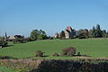
Verneuil is located about 37 kilometers southeast of Nevers on the Canal du Nivernais and the Aron . Verneuil is surrounded by the neighboring communities Diennes-Aubigny in the north, Cercy-la-Tour in the east, Charrin in the south and Champvert in the west.
Population development
| year | 1962 | 1968 | 1975 | 1982 | 1990 | 1999 | 2006 | 2013 |
| Residents | 501 | 486 | 408 | 381 | 397 | 329 | 332 | 323 |
| Source: Cassini and INSEE | ||||||||
Attractions
- Saint-Laurent church from the 12th century, monument historique since 1895
- Verneuil Castle from the 13th century, monument historique since 1991
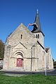
Saint Laurent Church
Verneuil Castle


literature
- Le Patrimoine des Communes de la Nièvre. Volume 1, Flohic Editions, Charenton-le-Pont 1999, ISBN 2-84234-054-X , pp. 378-381.
Web links
Commons : Verneuil - collection of images, videos and audio files