
Toury-Lurcy
| Toury-Lurcy | ||
|---|---|---|
|
||
| region | Bourgogne-Franche-Comté | |
| Department | Nièvre | |
| Arrondissement | Nevers | |
| Canton | Saint-Pierre-le-Moûtier | |
| Community association | Sud Nivernais | |
| Coordinates | 46 ° 44 ' N , 3 ° 26' E | |
| height | 197-252 m | |
| surface | 25.54 km 2 | |
| Residents | 430 (January 1, 2017) | |
| Population density | 17 inhabitants / km 2 | |
| Post Code | 58300 | |
| INSEE code | 58293 | |

Toury-Lurcy is a French municipality with 430 inhabitants (at January 1, 2017) in the department of Nièvre in the region of Bourgogne Franche-Comté (before 2016 Bourgogne ). It belongs to the Arrondissement of Nevers and the canton of Saint-Pierre-le-Moûtier (until 2015 Dornes ). The inhabitants are called Touryçois .
geography
Toury-Lurcy is about forty kilometers southeast of Nevers am Abron . Toury-Lurcy is surrounded by the neighboring communities of Saint-Germain-Chassenay in the north, Cossaye in the east and northeast, Lucenay-lès-Aix in the southeast, Saint-Ennemond in the south, Dornes in the west and southwest and Saint-Parize-en-Viry in the West.
Population development
| year | 1962 | 1968 | 1975 | 1982 | 1990 | 1999 | 2006 | 2013 |
| Residents | 480 | 451 | 406 | 389 | 442 | 427 | 410 | 422 |
| Source: Cassini and INSEE | ||||||||
Attractions
- Saint Martin Church
- Toury-Lurcy Castle

Saint Martin Church
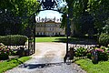
lock


literature
- Le Patrimoine des Communes de la Nièvre. Volume 1, Flohic Editions, Charenton-le-Pont 1999, ISBN 2-84234-054-X , pp. 425-426.
Web links
Commons : Toury-Lurcy - collection of images, videos and audio files