Saint-Saulge
| Saint-Saulge | ||
|---|---|---|
|
|
||
| region | Bourgogne-Franche-Comté | |
| Department | Nièvre | |
| Arrondissement | Nevers | |
| Canton | Guérigny | |
| Community association | Amognes Cœur du Nivernais | |
| Coordinates | 47 ° 6 ' N , 3 ° 31' E | |
| height | 245-403 m | |
| surface | 25.77 km 2 | |
| Residents | 738 (January 1, 2017) | |
| Population density | 29 inhabitants / km 2 | |
| Post Code | 58330 | |
| INSEE code | 58267 | |
| Website | www.saint-saulge.fr | |
 Town hall (Mairie) of Saint-Saulge |
||
Saint-Saulge is a French city with a population of 738 (as at 1st January 2017) in the department of Nièvre in the region of Bourgogne Franche-Comté . The municipality belongs to the Arrondissement of Nevers and the Canton of Guérigny (until 2015: Canton Saint-Saulge ).
geography
Saint-Saulge is about 60 kilometers south of Auxerre and about 25 kilometers east-northeast of Nevers . Saint-Saulge is surrounded by the neighboring communities of Crux-la-Ville in the north, Saint-Maurice in the east and northeast, Montapas in the east and southeast, Rouy in the south, Saxi-Bourdon in the southwest, Jailly in the west and southwest, Sainte-Marie in the West and north-west and Saint-Franchy in the north-west.
Population development
| 1962 | 1968 | 1975 | 1982 | 1990 | 1999 | 2006 | 2013 |
|---|---|---|---|---|---|---|---|
| 1,176 | 1,157 | 985 | 919 | 849 | 865 | 874 | 781 |
| Source: Cassini and INSEE | |||||||
Attractions
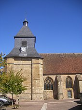
- Saint-Saulge church, old priory chapel from the 12th century, alterations from the 16th century, monument historique
Personalities
- Johannes Ravisius (1480–1524), humanist
literature
- Le Patrimoine des Communes de la Nièvre. Volume 2, Flohic Editions, Charenton-le-Pont 1999, ISBN 2-84234-054-X , pp. 976-979.
Web links
Commons : Saint-Saulge - Collection of images, videos and audio files

