
Luthenay-Uxeloup
| Luthenay-Uxeloup | ||
|---|---|---|
|
||
| region | Bourgogne-Franche-Comté | |
| Department | Nièvre | |
| Arrondissement | Nevers | |
| Canton | Saint-Pierre-le-Moûtier | |
| Community association | Nivernais Bourbonnais | |
| Coordinates | 46 ° 51 ′ N , 3 ° 16 ′ E | |
| height | 177-247 m | |
| surface | 37.69 km 2 | |
| Residents | 625 (January 1, 2017) | |
| Population density | 17 inhabitants / km 2 | |
| Post Code | 58240 | |
| INSEE code | 58148 | |
| Website | http://www.saint-parize-le-chatel.fr/ | |

Luthenay-Uxeloup is a French municipality with 625 inhabitants (as of January 1 2017) in the department of Nièvre in the region of Bourgogne Franche-Comté . It belongs to the arrondissement of Nevers and the canton of Saint-Pierre-le-Moûtier .
geography
Luthenay-Uxeloup is located about 13 kilometers south-southeast of Nevers on the Loire , which forms the northeastern municipal boundary. Luthenay-Uxeloup is surrounded by the neighboring communities of Chevenon and Imphy in the north, Saint-Ouen-sur-Loire in the north-east, Béard in the east and north-east, Fleury-sur-Loire in the east, Neuville-lès-Decize in the south-east, Azy-le- Vif in the south and southwest and Saint-Parize-le-Châtel in the west.
Population development
| year | 1962 | 1968 | 1975 | 1982 | 1990 | 1999 | 2006 | 2017 |
| Residents | 672 | 667 | 586 | 565 | 524 | 568 | 588 | 625 |
Source: INSEE
Attractions
- Saint-Aignan church, built in the early 12th century, monument historique
- Rosemont castle ruins, Monument historique
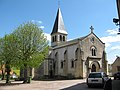
Saint-Aignan church

Rosemont castle ruins


literature
- Le Patrimoine des Communes de la Nièvre. Volume 2, Flohic Editions, Charenton-le-Pont 1999, ISBN 2-84234-054-X , pp. 940-942.