
Lossburg
| coat of arms | Germany map | |
|---|---|---|

|
Coordinates: 48 ° 25 ' N , 8 ° 27' E |
|
| Basic data | ||
| State : | Baden-Württemberg | |
| Administrative region : | Karlsruhe | |
| County : | Freudenstadt | |
| Height : | 666 m above sea level NHN | |
| Area : | 79.26 km 2 | |
| Residents: | 7442 (Dec. 31, 2018) | |
| Population density : | 94 inhabitants per km 2 | |
| Postal code : | 72290 | |
| Primaries : | 07446, 07455, 07444 | |
| License plate : | FDS, HCH , HOR, WOL | |
| Community key : | 08 2 37 045 | |
| Community structure: | 8 districts | |
| Address of the municipal administration: |
Hauptstrasse 50 72290 Loßburg |
|
| Website : | ||
| Mayor : | Christoph Enderle | |
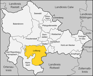
| Location of the municipality of Loßburg in the Freudenstadt district | ||
  |
||

Loßburg is a climatic health resort and a municipality in the Freudenstadt district in Baden-Württemberg . It belongs to the Northern Black Forest region .
geography
Tiny
The Kinzig rises in the district of Loßburg and flows into the Rhine after 93 km at Kehl .
Community structure
The entire municipality of Loßburg consists of the eight districts Loßburg, Betzweiler , Lombach , Schömberg , Sterneck , 24-Höfe , Wilder and Wittendorf with a total of 64 villages, hamlets, Zinken, farms and houses.
The official naming of the districts with the exception of the district of Loßburg takes the form "Loßburg- ...". In the districts with the exception of the district of Loßburg, six localities within the meaning of the Baden-Württemberg municipal code, each with their own local council and mayor as its chairman, are set up, with the districts of Betzweiler and Waeler being combined into one locality. In some localities, the false suburbs are used accordingly, that is, the electoral area for the election of the local council is divided into several residential districts.
The Stehelinshof zu Vischach desert lies in the Lombach district .
history
The Lossburg area was originally obviously under the control of the Counts of Sulz . With the marriage of a daughter of Count Berthold von Sulz to Walther von Tiersberg († 1235, line Tiersberg / Geroldseck), the property must have passed to the Geroldsecker . The son Walther (2), now called von Geroldseck, married Heilika von Finstingen in 1252. Around this time the Geroldseckers, the later Hohengeroldseckers with their castle between Schuttertal and Kinzigtal, built the "Loseburch" with the place planned as a town. A city charter has not been granted. According to a dendrochronological examination of an oak beam from Loßburg Castle, the construction period was between 1252 and 1273.
From the Kinzigursprung the Geroldsecker drew a moat (ahd. Losi) to their new castle and expanded the hilltop castle into a moated castle according to their ancestral castle Lahr. Adolf Bach derives place names with Loose or Losen from "losi" (= drainage ditch). Dr. Schöck, head of the regional office for folklore in Stuttgart, sees such a derivation also applicable to Lossburg. The place was first mentioned in 1282 as "Loseburch" and in 1301 received market rights.
Water supply
The moat derived from the Kinzig, now called Mühlbach, once provided only a small amount of water for the place. Therefore, strict regulations for the water consumption of the Kinzig were enacted in the proclamations of Lossburg from 1539. The regulations go back to orders of the Geroldsecker from the 15th century. A special water-scooping point was created to keep everyone the same, i.e. H. treat fairly. A Teuchelleitung did not exist back then. The water should go to the mill by Saturday noon and should not be taken by any “poor man” to irrigate the meadows. The rulers had the privilege for four weeks. The moat should be kept half a shoe deep. No diapers may be washed in the ditch on site. Wash water should be scooped into a bucket. After that, the remaining water should not be poured away, but instead fed into the side stream. The language houses (wards, toilets) and the pigsties can then be cleaned of this.
Official affiliation
The Geroldsecker pledged their rule in 1468 to the House of Württemberg , which thus became sovereign. From 1501 the property was owned by Alpirsbach Abbey . In the peasant wars , the Loßburg peasant leader Thomas Maier played a major role, he was beheaded after the battle of Böblingen in 1525.
The Reformation carried out in Württemberg led to the secularization of the Alpirsbach monastery. Lossburg came to the newly created monastery office in Alpirsbach. In the course of the administrative reorganization of the Kingdom of Württemberg , the place came to the Oberamt Freudenstadt at the beginning of the 19th century . During the district reform in Württemberg during the Nazi era , Lossburg became part of the Freudenstadt district in 1938 . After the Second World War, the municipality fell into the French zone of occupation and thus came to the newly founded state of Württemberg-Hohenzollern , which in 1952 became the administrative district of Südwürttemberg-Hohenzollern in the state of Baden-Württemberg. Since the district reform in Baden-Württemberg in 1973, Loßburg has been in the Karlsruhe district .
Religions
Lossburg has been evangelical since the Reformation , but Lossburg also has a Roman Catholic church , named after St. Martin. In addition to the communities, there is also a local branch of the Liebenzeller community . There is also a New Apostolic church.
Incorporations
- 1938: incorporation of Rodt
- January 1, 1971: Betzweiler and Waeler merge to form the new municipality of Betzweiler-Wilder
- September 1, 1971: incorporation of Sterneck
- July 1, 1974: Incorporation of Lombach, Schömberg, Zwanzig-Vierundzwanzig Höfe and Wittendorf
- October 1, 1976: Umgemeinde from Hardthöfle (previously Alpirsbach ) to Loßburg
- January 1, 2007: Incorporation of Betzweiler-Wilder
In a referendum on March 26, 2006, the majority of the citizens of the community of Betzweiler-Waele, which emerged on January 1, 1971 from the places Betzweiler and Waele, decided in favor of incorporation into Lossburg. Betzweiler-Wäldes was incorporated on January 1, 2007.
politics
Municipal council
The municipal council consists of the elected voluntary councilors and the mayor as chairman. The mayor is entitled to vote in the municipal council.
The municipal council election on May 26, 2019 led to the following result:
| Party / list | Share of votes | Seats | 2014 | |
| Free voters | 66.2% | 12 | 63.1%, 12 seats | |
| CDU | 14.6% | 3 | 18.7%, 3 seats | |
| Green list | 14.3% | 2 | - - | |
| SPD | 4.9% | 1 | 18.2%, 3 seats | |
| voter turnout | 65.6% | 49.2% | ||
mayor

Christoph Enderle was elected to succeed Thilo Schreiber in the first ballot in January 2013.
coat of arms
Blazon : In blue on a green hill a silver tower, above the white / silver letter 'L'. The green base of the shield is to be seen as a heraldic emblem.
Partnerships
Loßburg maintains partnerships with Anse (France), Harta (Hungary) and Hammerbrücke (Saxony).
Economy and Infrastructure
Among other things, tourism is of economic importance. Loßburg, Rodt and Ödenwald are recognized as climatic health resorts.
traffic
Loßburg is on the federal road 294 ( Bretten - Freiburg ) and on the Kinzig valley railway ( Freudenstadt - Hausach ). There are direct connections to Freudenstadt and Offenburg . The district town of Freudenstadt is seven kilometers away.
education
In the education center Loßburg there is a secondary school with a Werkrealschule and a community school with a primary school. There is also a joint primary school for the districts of Wittendorf and Lombach.
Established businesses
Arburg is a manufacturer of machines for plastics processing with branches at 33 locations in 25 countries. Production takes place in the main factory in Lossburg. Of the total of around 3,000 employees, around 2,500 are employed in Germany.
Culture and sights

Lossburg is located on the Jakobusweg in the Kinzig Valley, which leads past many sights from Rottenburg am Neckar via Schutterwald to Strasbourg. Special attractions for tourists in Lossburg are:
- The Sterneck castle ruins
- The "historic Heimbachmühle", a mill from the 13th century (today a hotel inn) in Betzweiler
- The "Old Church" (today a café and inn) in Unterbrändi (Sterneck)
- The "Vogteiturm", a 35 m high observation tower not far northwest of the village
Museums
Loßburg has a Black Forest and local history museum.
Personalities
sons and daughters of the town
- 1901, April 3, Rudi Paret (in the Wittendorf district), † January 31, 1983 in Tübingen, Islamic scholar and Koran translator
- 1902, January 18, Ernst Huber (in the Sterneck district), † after 1944, politician (NSDAP), member of the state and Reichstag
- 1903, November 20, Hugo Barth (in the Rodt district), † May 5, 1976 in Nürtingen, decathlete and hurdler
- 1990, January 22nd, Benedikt Karus , athlete, German champion in obstacle and cross-country running.
Other personalities associated with the community
- The lute player, musician and composer Ben Salfield lived in Lossburg as a child.
Leisure and Tourism
Motorcycle service
Every July there is a service for motorcyclists at the EC-Lebenshof in Sterneck with an estimated 200 visitors.
Heimbachaue nature reserve
The Heimbachaue nature reserve is located between the districts of Betzweiler and Wilder . Numerous plants and animals threatened with extinction have found protection and habitat here.
Web links
Individual evidence
- ↑ State Statistical Office Baden-Württemberg - Population by nationality and gender on December 31, 2018 (CSV file) ( help on this ).
-
↑ Sources for the section on community structure:
Das Land Baden-Württemberg. Official description by district and municipality. Volume V: Karlsruhe District Kohlhammer, Stuttgart 1976, ISBN 3-17-002542-2 . P. 647–652
Main statutes of the municipality of Loßburg from January 9, 2007 (PDF; accessed on August 21, 2008) - ↑ See Bühler, Christoph, Die Herrschaft Geroldseck , Stuttgart 1981, pp. 140–142 and pp. 168f
- ↑ See Hofmann, Jutta, report "Jahrringlabor Hofmann, Nürtingen, order number 190391 and 190392, in: Gemeindearchiv Loßburg, and Saile, Hans, Geschichtlicher Abriss von Loßburg and its sub-locations , Freudenstadt 1999, p. 18
- ↑ See Bach, Adolf , Deutsche Namenkunde, Vol. II / 1, § 299, Heidelberg 1981.
- ↑ References: Main State Archives Stuttgart: A 470, Bü 73, fol. 1-7; H 102/2, vol. 10, fol. 18-19
- ↑ a b Federal Statistical Office (ed.): Historical municipality register for the Federal Republic of Germany. Name, border and key number changes in municipalities, counties and administrative districts from May 27, 1970 to December 31, 1982 . W. Kohlhammer, Stuttgart / Mainz 1983, ISBN 3-17-003263-1 , p. 528 .
- ^ Federal Statistical Office (ed.): Historical municipality directory for the Federal Republic of Germany. Name, border and key number changes in municipalities, counties and administrative districts from May 27, 1970 to December 31, 1982 . W. Kohlhammer, Stuttgart / Mainz 1983, ISBN 3-17-003263-1 , p. 492 .
- ^ Federal Statistical Office (ed.): Historical municipality directory for the Federal Republic of Germany. Name, border and key number changes in municipalities, counties and administrative districts from May 27, 1970 to December 31, 1982 . W. Kohlhammer, Stuttgart / Mainz 1983, ISBN 3-17-003263-1 , p. 493 .
- ^ StBA: Changes in the municipalities in Germany, see 2007
- ↑ Baden-Württemberg State Statistical Office, result of the 2019 municipal council elections - Loßburg , accessed on April 30, 2020
- ↑ http://www.lossburg.de/de/rathaus/mitarbeiter/enderle-christoph-id_65/?amt=55
- ↑ Bailiwick tower Rodt at Lossburg on badische-seiten.de
