
Waldenburg (Württemberg)
| coat of arms | Germany map | |
|---|---|---|

|
Coordinates: 49 ° 11 ' N , 9 ° 39' E |
|
| Basic data | ||
| State : | Baden-Württemberg | |
| Administrative region : | Stuttgart | |
| County : | Hohenlohe district | |
| Local government association: | "Hohenlohe Plain" | |
| Height : | 500 m above sea level NHN | |
| Area : | 31.55 km 2 | |
| Residents: | 3094 (December 31, 2018) | |
| Population density : | 98 inhabitants per km 2 | |
| Postcodes : | 74638, 74545 | |
| Primaries : | 07942, 07949 | |
| License plate : | KÜN, EAR | |
| Community key : | 08 1 26 085 | |
| City structure: | 3 districts | |
City administration address : |
Hauptstrasse 13 74638 Waldenburg |
|
| Website : | ||
| Mayor : | Markus Knobel | |
| Location of the city of Waldenburg in the Hohenlohe district | ||
  |
||


Waldenburg is a small town and a climatic health resort in the Hohenlohe district in the Franconian north-east of Baden-Württemberg, north of the eponymous district town of Schwäbisch Hall in the neighboring district. It belongs to the Heilbronn-Franconia region (until May 20, 2003 Franconia region ).
geography

Waldenburg has a share in the natural areas of the Swabian-Franconian Forest Mountains and Hohenloher - Haller Ebene .
City structure
Waldenburg consists of Waldenburg itself and the districts of Obersteinbach (173 inhabitants as of March 31, 2006) and Sailach (222 inhabitants).
The village of Obersteinbach, the hamlet of Sailach and the residential area Hinterziegelhalden belong to Obersteinbach . To Waldenburg the town of Waldenburg, the hamlets Goldbach, Großlindig, Hohenau, Kleinlindig, Obermühle, Tommelhardt, Untermühle and Ziegelhütte, the ducal domain Hohebuch, the farms Laurach and Rebbigshof (partly, also to Neuenstein) and the residential areas at the train station Waldenburg, Buchhaus, Fischhaus , Kelterrain, Neumühle and Streithof. The Fasanenmühle residential area has gone.
Division of space

According to data from the State Statistical Office , as of 2014.
history
From the 13th to the 20th century
Waldenburg was first mentioned in a document in 1253 and designated as a city in 1330. With the division of Hohenlohe in 1553, Waldenburg became the residence of the counts and later princes of Hohenlohe-Waldenburg . The plague and the chaos of war significantly decimated the population in the Thirty Years' War . The city was part of Hohenlohe in the Franconian Empire . As a result of the Rhine Confederation Act , the city fell to the Kingdom of Württemberg in 1806 . Initially assigned to the Oberamt Neuenstein, from 1809 Waldenburg was part of the administrative unit now known as the Oberamt Öhringen . On August 4, 1862, with the opening of the line from Heilbronn to Hall , Waldenburg was connected to the rail network of the Württemberg Railway . In 1938 Waldenburg came to the district of Öhringen and with this in 1945 it became part of the state of Württemberg-Baden .
In the last days of the war in April 1945, Waldenburg, which was originally not supposed to be defended, was declared a "fortress" by an advancing German unit and as a result almost completely destroyed by American artillery units. Waldenburg was then rebuilt in a historical guise, taking modern aspects into account.
Waldenburg has been part of the state of Baden-Württemberg since 1952 . In 1957 the first Albert Schweitzer Children's Village in Waldenburg was founded by Margarethe Gutöhrlein.
On January 1, 1971 Obersteinbach was incorporated.
Religions
Evangelical, Catholic and New Apostolic church congregations exist in Waldenburg.
The Catholic parish “Immaculate Conception” forms together with the parishes “St. Petrus and Paulus ”by Pfedelbach and“ St. Stephan “ Bretzfeld started a pastoral care unit.
Population development
- 1648: 640 inhabitants
- 1961: 1823 inhabitants, 334 of them in Obersteinbach
- 1970: 2204 inhabitants, 351 of them in Obersteinbach
- 1991: 2977 inhabitants
- 1995: 3062 inhabitants
- 2000: 3079 inhabitants
- 2005: 3083 inhabitants
- 2010: 3008 inhabitants
- 2015: 3046 inhabitants
politics
Municipal council
The 15 members of the municipal council belong to two electoral associations; After the local elections on May 26, 2019 , the Waldenburg Citizens' Association will provide nine and the Free Voting Community Waldenburg five local councils.
Since 1992 there has also been a youth council in the city. He is the mouthpiece and advocacy of young people. All 13 to 19 year olds who live in Waldenburg are entitled to vote. The last election took place on July 6, 2012.
mayor
- Friedrich Ebel (June – November 1945)
- Franz Gehweiler (November 1945 – March 1978)
- Gerhard Lauth (March 1978 – August 1990)
- Roland Weinschenk (December 1990 – April 2004)
- Markus Knobel (since July 26, 2004)
badges and flags

The blazon of the Waldenburg coat of arms reads: In a divided shield above in gold on green ground, three green fir trees, below in silver a striding, red armored, looking black lion (leopard) with a folded tail. The city's flag is red and white.
The coat of arms, which can be proven in the seals of Waldenburg since the 16th century, takes up the city name in the upper half and shows the Hohenlohe heraldic animal with the leopard in the lower half . The city colors are the Hohenlohe house colors.
Partnerships
Waldenburg has had a partnership with Sierck-les-Bains in Lorraine , France , since 1970 . There are also friendly relationships with the communities of the same name, Waldenburg in Saxony and Waldenburg in Switzerland.
Economy and Infrastructure
traffic
Waldenburg is on the federal highway 6 and the federal highway 19 .
The Waldenburg (Württ) train station is in the HNV area and is on the Heilbronn – Crailsheim railway line . A regional express from Heilbronn – Crailsheim runs every two hours, and in the hours in between, the Öhringen – Schwäbisch Hall – Hessental regional train runs.
Established businesses
The Hohenlohe business park is a special purpose association of the municipalities of Waldenburg, Kupferzell and Künzelsau and has an area of 230 ha, of which 135 ha are developed. It is located at the foot of the Waldenburg Mountains in the immediate vicinity of the Waldenburg train station, federal motorway 6 and federal highway 19.
The following companies, among others, have their headquarters or production facilities in the industrial park:
- R. Stahl
- Ziehl-Abegg
- SWG (Gaisbach Screw Factory) of the Würth Group
- Lidl
- Wolff & Müller
- Würth Elektronik eiSos, part of the Würth Elektronik group of companies
- GEMÜ
Social facilities
- Albert Schweitzer Children's Village Waldenburg
Culture and sights

town hall
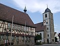
church

Laughter storm

panorama

Entrance


Museums
- Since 1971 the castle has housed a museum with collections of seals since the early Middle Ages.
- A 1978 on the occasion of dinosaur finds in the construction of the A 6 at City Hall decorated Urweltmuseum is closed as of 2016 and is scheduled to open again in another form.
Buildings
- Waldenburg Castle
- church
- Lachnersturm (33 m high keep), which serves as a lookout tower with its tower room .
- Remains of the Goldbach monastery on the Goldbach settlement
- To the east of Waldenburg, Südwestrundfunk has operated the 150 m high broadcast tower Waldenburg-Friedrichsberg, a basic network transmitter for radio and television, since 2008. The Waldenburg television tower was in operation in the village until 2009, and was dismantled into a water tower after it was decommissioned .
nature

- The nature reserves Rößlesmahdsee with Pfaffenklinge and Eastern Goldbachsee are close to the Goldbach settlement .
- Between Obersteinbach and the hamlet of Tommelhardt are the nature reserves Obere Weide and Entlesboden , which show the natural vegetation of old hat forests.
leisure
- Exercise garden of the Albert Schweitzer Children's Village.
Personalities
- Rosinus Lentilius (1657–1733), born in Waldenburg, personal physician to Duke Eberhard Ludwig in Stuttgart and member of the " Leopoldina " academy of scholars
- Karl von Raiffeisen (1820–1888), born in Waldenburg, Protestant theologian, general superintendent of Heilbronn
- Hans Hege (1885–1983), tenant of the Hohebuch domain, plant breeder and member of the Baden-Württemberg state parliament
- Hans-Ulrich Hege (* 1928), graduate farmer, plant breeder, mechanical engineer and tenant in Hohebuch
literature
- Karlheinz Englert: Waldenburg. Image of a town in Hohenlohe . Geiger, Horb am Neckar 2003, ISBN 3-89570-862-3 .
Web links
- LEO-BW, discover regional studies online , Waldenburg
Individual evidence
- ↑ State Statistical Office Baden-Württemberg - Population by nationality and gender on December 31, 2018 (CSV file) ( help on this ).
- ↑ Natural areas of Baden-Württemberg . State Institute for the Environment, Measurements and Nature Conservation Baden-Württemberg, Stuttgart 2009.
-
↑
Source for the urban structure section:
Das Land Baden-Württemberg. Official description by district and municipality. Volume IV: Stuttgart district, Franconian and East Württemberg regional associations. Kohlhammer, Stuttgart 1980, ISBN 3-17-005708-1 . P. 217–220
Additional sources on places to live in Neuenstein and Waldenburg:
Website of the city of Neuenstein zu Kesselfeld ( memento of the original from October 10, 2010 in the Internet Archive ) Info: The archive link was automatically inserted and not yet checked. Please check the original and archive link according to the instructions and then remove this notice. (accessed on June 12, 2011) The Hohenlohekreis . Edited by the Baden-Württemberg State Archive in conjunction with the Hohenlohe district. Thorbecke, Ostfildern 2006, ISBN 3-7995-1367-1 , Volume 2, pp. 345 and 426 ( Baden-Württemberg - The country in its circles ) Karlheinz Englert: Waldenburg. Image of a town in Hohenlohe . Geiger, Horb am Neckar 2003, ISBN 3-89570-862-3 , pp. 82–83, 99, 109.
- ↑ State Statistical Office, area since 1988 according to actual use for Waldenburg.
- ↑ http://www.waldenburg-hohenlohe.de/fileadmin/Dateien/Dateien/HistorischeWegeWaldenburg_300.pdf waldenburg-hohenlohe.de
- ^ History on the website of the city of Waldenburg
- ^ Federal Statistical Office (ed.): Historical municipality directory for the Federal Republic of Germany. Name, border and key number changes in municipalities, counties and administrative districts from May 27, 1970 to December 31, 1982 . W. Kohlhammer, Stuttgart / Mainz 1983, ISBN 3-17-003263-1 , p. 467 .
- ^ Local councils on the website of the city of Waldenburg
- ↑ Youth council on the website of the city of Waldenburg
- ↑ Heinz Bardua: The district and community coats of arms in the Stuttgart administrative region . Theiss, Stuttgart 1987, ISBN 3-8062-0801-8 (district and municipality coat of arms in Baden-Württemberg, 1), p. 136.
- ↑ seal museum on the site of the city Waldenburg
- ↑ Juliane Renk: Urweltmuseum closes - new concept sought . In: Hohenloher Zeitung , November 16, 2015
- ↑ Lachnersturm on burgenstrasse.de
- ↑ a b See Geoportal Baden-Württemberg ( information ), maps of the State Institute for the Environment, Measurements, Nature Conservation ( LUBW ).
Bank of the clergy princes: Bamberg Monastery | Würzburg Monastery | Hochstift Eichstätt | Ballei Franken of the Teutonic Order . Bank of the secular princes: Margraviate Brandenburg-Ansbach | Markgraftum Brandenburg-Kulmbach (or after 1604 Brandenburg-Bayreuth) | Princely County of Henneberg | until 1792: Duchy of Saxony-Meiningen | Fürstete Grafschaft Löwenstein-Wertheim | Fürstete Grafschaft Hohenlohe - Waldenburg . Bank of the Counts and Lords: Grafschaft Castell | County of Erbach | County of Hohenlohe | Lordship of Limpurg | Reign of Reichelsberg | County of Rieneck | Lordship of Schwarzenberg | County of Wertheim | until 1792: Herrschaft Hausen | Reign of Seinsheim | Reign of Welzheim | Rule Wiesentheid . Bank of the Cities: Nuremberg | Rothenburg | Schweinfurt | Weißenburg | Windsheim

Bretzfeld | Dörzbach | Forchtenberg | Ingelfingen | Krautheim | Künzelsau | Copper cell | Mulfingen | Neuenstein | Niedernhall | Öhringen | Pfedelbach | Schöntal | Waldenburg | Weissbach | Doubts